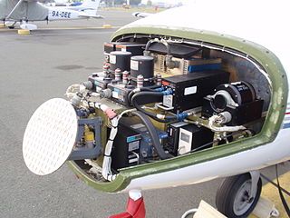
Avionics are the electronic systems used on aircraft. Avionic systems include communications, navigation, the display and management of multiple systems, and the hundreds of systems that are fitted to aircraft to perform individual functions. These can be as simple as a searchlight for a police helicopter or as complicated as the tactical system for an airborne early warning platform.
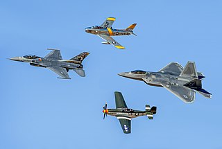
Fighter aircraft are fixed-wing military aircraft designed primarily for air-to-air combat. In military conflict, the role of fighter aircraft is to establish air superiority of the battlespace. Domination of the airspace above a battlefield permits bombers and attack aircraft to engage in tactical and strategic bombing of enemy targets.

An altimeter or an altitude meter is an instrument used to measure the altitude of an object above a fixed level. The measurement of altitude is called altimetry, which is related to the term bathymetry, the measurement of depth under water. The most common unit for altimeter calibration worldwide is hectopascals (hPa), except for North America and Japan where inches of mercury (inHg) are used. To obtain an accurate altitude reading in either feet or meters, the local barometric pressure must be calibrated correctly using the barometric formula.
A military aircraft is any fixed-wing or rotary-wing aircraft that is operated by a legal or insurrectionary military of any type. Military aircraft can be either combat or non-combat:

An interceptor aircraft, or simply interceptor, is a type of fighter aircraft designed specifically for the defensive interception role against an attacking enemy aircraft, particularly bombers and reconnaissance aircraft. Aircraft that are capable of being or are employed as both ‘standard’ air superiority fighters and as interceptors are sometimes known as fighter-interceptors. There are two general classes of interceptor: light fighters, designed for high performance over short range; and heavy fighters, which are intended to operate over longer ranges, in contested airspace and adverse meteorological conditions. While the second type was exemplified historically by specialized night fighter and all-weather interceptor designs, the integration of mid-air refueling, satellite navigation, on-board radar and beyond visual range (BVR) missile systems since the 1960s has allowed most frontline fighter designs to fill the roles once reserved for specialised night/all-weather fighters.

The fourth-generation fighter is a class of jet fighters in service from around 1980 to the present, and represents design concepts of the 1970s. Fourth-generation designs are heavily influenced by lessons learned from the previous generation of combat aircraft. Third-generation fighters were often designed primarily as interceptors, being built around speed and air-to-air missiles. While exceptionally fast in a straight line, many third-generation fighters severely lacked in manoeuvrability, as doctrine held that traditional dogfighting would be impossible at supersonic speeds. In practice, air-to-air missiles of the time, despite being responsible for the vast majority of air-to-air victories, were relatively unreliable, and combat would quickly become subsonic and close-range. This would leave third-generation fighters vulnerable and ill-equipped, renewing an interest in manoeuvrability for the fourth generation of fighters. Meanwhile, the growing costs of military aircraft in general and the demonstrated success of aircraft such as the McDonnell Douglas F-4 Phantom II gave rise to the popularity of multirole combat aircraft in parallel with the advances marking the so-called fourth generation.

In aviation and aviation meteorology, a flight level (FL) is an aircraft's altitude at standard air pressure, expressed in hundreds of feet. The air pressure is computed assuming an International Standard Atmosphere pressure of 1013.25 hPa (29.92 inHg) at sea level, and therefore is not necessarily the same as the aircraft's actual altitude, either above sea level or above ground level.
Aviation is the design, development, production, operation, and use of aircraft, especially heavier-than-air aircraft. Articles related to aviation include:

Stealth aircraft are designed to avoid detection using a variety of technologies that reduce reflection/emission of radar, infrared, visible light, radio frequency (RF) spectrum, and audio, collectively known as stealth technology. The F-117 Nighthawk was the first operational aircraft specifically designed around stealth technology. Other examples of stealth aircraft include the B-2 Spirit, the B-21 Raider, the F-22 Raptor, the F-35 Lightning II, the Chengdu J-20, and the Sukhoi Su-57.
A ground proximity warning system (GPWS) is a system designed to alert pilots if their aircraft is in immediate danger of flying into the ground or an obstacle. The United States Federal Aviation Administration (FAA) defines GPWS as a type of terrain awareness warning system (TAWS). More advanced systems, introduced in 1996, are known as enhanced ground proximity warning systems (EGPWS), a modern type of TAWS.

LANTIRN (Low Altitude Navigation and Targeting Infrared for Night) is a combined navigation and targeting pod system for use on the United States Air Force fighter aircraft—the F-15E Strike Eagle and F-16 Fighting Falcon (Block 40/42 C & D models) manufactured by Martin Marietta (now Lockheed Martin). LANTIRN significantly increases the combat effectiveness of these aircraft, allowing them to fly at low altitudes, at night and under-the-weather to attack ground targets with a variety of precision-guided weapons.

Military aviation comprises military aircraft and other flying machines for the purposes of conducting or enabling aerial warfare, including national airlift capacity to provide logistical supply to forces stationed in a war theater or along a front. Airpower includes the national means of conducting such warfare, including the intersection of transport and warcraft. Military aircraft include bombers, fighters, transports, trainer aircraft, and reconnaissance aircraft.

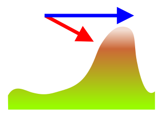
Terrain-following radar (TFR) is a military aerospace technology that allows a very-low-flying aircraft to automatically maintain a relatively constant altitude above ground level and therefore make detection by enemy radar more difficult. It is sometimes referred to as ground hugging or terrain hugging flight. The term nap-of-the-earth flight may also apply but is more commonly used in relation to low-flying military helicopters, which typically do not use terrain-following radar.

The Lockheed DC-130 is a variant of the C-130 Hercules designed for drone control. It can carry four Ryan Firebee drones underneath its wings.

The ADM-141A/B TALD was an American decoy missile originally built by Brunswick Corporation for the United States Air Force and the Israeli Air Force. Later it transitioned to joint US/Israeli manufacture with Israeli Military Industries Advanced Systems Division (IMI-ASD).

A radar altimeter (RA), also called a radio altimeter (RALT), electronic altimeter, reflection altimeter, or low-range radio altimeter (LRRA), measures altitude above the terrain presently beneath an aircraft or spacecraft by timing how long it takes a beam of radio waves to travel to ground, reflect, and return to the craft. This type of altimeter provides the distance between the antenna and the ground directly below it, in contrast to a barometric altimeter which provides the distance above a defined vertical datum, usually mean sea level.
Terrain contour matching, or TERCOM, is a navigation system used primarily by cruise missiles. It uses a contour map of the terrain that is compared with measurements made during flight by an on-board radar altimeter. A TERCOM system considerably increases the accuracy of a missile compared with inertial navigation systems (INS). The increased accuracy allows a TERCOM-equipped missile to fly closer to obstacles and at generally lower altitudes, making it harder to detect by ground radar.

American Airlines Flight 1572 was a flight from Chicago O'Hare International Airport to Bradley International Airport on November 12, 1995. The McDonnell Douglas MD-83 struck trees and an instrument landing system (ILS) antenna during landing, causing $9 million in damage to the aircraft.

Low flying military training involves military aircraft flying at low altitude to prepare their aircrew, and other military personnel, for nap-of-the-earth flying in wartime. The aircraft types can include advanced trainers, ground-attack aircraft, transports and helicopters.
Blue Joker was an experimental moored balloon-mounted, airborne early-warning radar project developed by the Royal Radar Establishment (RRE) starting in 1953. The idea was to position the radar high in the air in order to extend its radar horizon and allow it to see low-flying aircraft. Ground reflections were filtered out using a moving target indicator (MTI) system. Two examples were built and tested in the late 1950s, but the project was cancelled in 1960 as part of the Linesman/Mediator efforts.


