
The Pulwama district is located to the south of Srinagar in Indian-administered Kashmir. Its district headquarters are situated in the city of Pulwama. It is located in the central part of the Kashmir Valley.
Pulwama is a City and notified area council in the Pulwama district of the Indian-administered territory of Jammu and Kashmir. It is located approximately 25 kilometres (16 mi) south of the summer capital of Srinagar.
Handwara is a sub-district and a town in Kupwara district of Kashmir. It was known as Uttar Machipora until the division of Baramulla district in the 1980s resulting in the formation of two new districts: Kupwara and Bandipora. It is located on Baramulla-Handwara National Highway NH-701 and is governed by a municipal committee.
Magam is a tehsil in central Kashmir's Beerwah sub-district. It is also a town, notified area committee, and a block in Budgam district in the Indian administered union territory of Jammu and Kashmir. It is 11 km (6.8 mi) away from sub-district headquarter Beerwah and 20 km (12 mi) away from Srinagar, the summer capital of Jammu and Kashmir. Magam is top business hub in this locality, which comes before on the way to gulmarg. Magam comes both in baramulla district and budgam which makes this famous across these districts for business.

Kupwara district is one of the 10 districts located in the Kashmir Valley Division of Indian administered Kashmir. The talri river( originating in lolab valley and flowing from east to west) and Mawar river are two main rivers in the district. Both of them meet Jhelum river in Baramulla district.

Budgam district is a district in the Indian-administered union territory of Jammu and Kashmir. Created in 1979 with its headquarters at Budgam, it is the district with the largest population of Shias in the Kashmir valley.

Bandipore district is one of the 20 districts in the Indian union territory of Jammu and Kashmir. Bandipore town is the administrative headquarters of the district. Bandipore, a township with peculiar scenic beauty is located in the foothills of the snow-clad peaks of Harmukh overlooking the shores of Wular Lake and has produced hundreds of scholars and intellectuals. The district is famous for its tourist places such as Wular Vintage Park, Athwatoo and Gurez valley. Before 1947, this town was a big trade and literary centre of Kashmir. This district was carved out from the erstwhile Baramulla district in 2007. The district is bounded by Kupwara district from the north, Baramulla district from west and Kargil district in Ladakh and Ganderbal district from the east. This district occupies an area of 398 km2. The district has a population of 392,232 as per 2011 census.

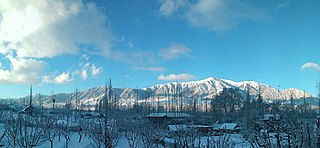
Rathsun or Rathsoon is a village and block located in the Jammu and Kashmir's Budgam district. It is situated at the base of the Pir Panjal Range of the Himalayas. It falls under the administrative division of tehsil Beerwah one of the nine tehsils of district Budgam. It is about 23.7 km via Beerwah-Budgam Road from district headquarters Budgam, 7 km (4.3 mi) from sub-district headquarters Beerwah, known as the Gateway of Doodhpathri and Gateway of Tosamaidan, and 29 km away from Srinagar, the summer capital of Jammu and Kashmir. Magam, known as the Business Hub of Budgam district and the Gateway of Gulmarg, is nearest town to Rathsun which is approximately 4 kilometres (2.5 mi) away.
Nussu is a village in the district Budgam, tehsil Beerwah in the Indian administered union territory of Jammu and Kashmir. It is located about 29 km (18 mi) west of the district headquarters, Budgam, and about 34 km (21 mi) west of union territory capital Srinagar.

Pethmakhama is a village in Budgam district, in the Indian administrative union territory of Jammu and Kashmir. It falls under the administrative division of tehsil Magam. It is famous for the shrine of Mir Sayyid Ali Hamadani who stayed at various places in and around Kashmir and one example is Pethmakhama where he prayed for around two months. The stone on which he prayed there, has the marks of praying on it miraculously and is preserved at Aasar-i-Shareef Pethmakhama. The shrine also hosts beard hair as one of the holy Relics of Muhammad which is displayed to the devotees every year on the auspicious occasion of Mehraj ul Alam and other festivals. Pethmakhama is irrigated throughout the year by River Sukhnag which is a tributary of Jhelum River and various springs in the village.
Aripanthan is a village and panchayat halqa in Beerwah tehsil of Budgam district in the Indian union territory of Jammu and Kashmir. It is situated at the centre of tehsil Beerwah and tehsil Magam. It is located about 27 km (17 mi) west from summer capital of Jammu and Kashmir, Srinagar and about 28 km (17 mi) north from district headquarters in Budgam.

Akingam is a village in South Kashmir in the Anantnag district, in the Indian union territory of Jammu and Kashmir. It is at a distance of approximately 14.2 kilometres (8.8 mi) from the Lal Chowk along a route passing through the tourist resorts of Achabal and Kokernag. In revenue records, the village of Akingam is still called Maqan Shiva Bhagwati. The adjacent villages are Mohripura, Hiller, Badasgam, Hardpora and Badoora.
Badran is a village located in district Budgam in the Indian administered union territory of Jammu and Kashmir.
Kondur or Kandoora is the largest village in the Sukhnag River valley, located on the eastern banks of the Sukhnag River. It lies on the Beerwah-to-Doodhpathri road and is 26 kilometres (16 mi) from Srinagar, the largest city and summer capital of the union territory of Jammu and Kashmir, which is the southern portion of the wider Indian-administered Kashmir region.

Chewdara or Chivdora, is a village in the Rathsun block of the Beerwah tehsil in Budgam district of Jammu and Kashmir, India. It is located 21 km (13 mi) towards west of the Budgam district headquarters, 3 km (1.9 mi) from Beerwah and 23 km (14 mi) from the winter capital Srinagar. Chewdara has two panchayats, Chewdara-A and Chewdara-B.
Sonapah is a village in tehsil Beerwah, district Budgam of the Jammu and Kashmir (India).
Ohangam is a village in tehsil Beerwah of district Budgam of the Jammu and Kashmir. its population is about 3500. The famous Kashmiri poet and the author of Kashmiri folktale Heemal Nagrai, Waliullah Mattu is from the same village. The shrine of famous sufi saint Baba Hanief Ud Din Reshi is lacated in the North East of Ohangam.
Sechin Banet is a village in tehsil Beerwah of district Budgam of the Jammu and Kashmir.
Otligam is a village in tehsil Beerwah of district Budgam of the Jammu and Kashmir.. Village plays an important role with respect to education, banking facilities as well as the road connectivity of adjoining villages. Besides this the village has a Primary Health Centre set by Ministry of Ayush.
Gondipora is a village in tehsil Beerwah of district Budgam of the Jammu and Kashmir.

