This article needs additional citations for verification .(June 2019) |
Narnoor is a mandal in the Adilabad district of the Indian state of Telangana. [1]
This article needs additional citations for verification .(June 2019) |
Narnoor is a mandal in the Adilabad district of the Indian state of Telangana. [1]
Narnoor Mandal consists of 24 Gramapanchayat. The village is in the agency area, which is headed under the Integrated Tribal Development Agency Utnoor. The mandal is divided into two more mandals, the second one being Gandiguda.
Telugu is the Local Language here. Total population of Narnoor is 3636 .Males are 1937 and Females are 1,699 living in 599 Houses. Total area of Narnoor is 750 hectares. Narnoor Local Language is Telugu. Narnoor town Total population is 5035 and number of houses are 889. Female Population is 45.4%. town literacy rate is 70.0% and the Female Literacy rate is 28.2%. Ninety percent of Narnoor Mandal residents are members of scheduled tribes, notably the Gonds, Kolams, Mahar, Buddhist and Lamabadie.
TDP , TRS , CPI , INC are the major political parties in this area.
1)Narlapur 2)Narnoor 3)Narnoor 4)Bendara 5)Manik Guda H/o. Jhandaguda
By Road : Adilabad is the Nearest Town to Narnoor. Adilabad is 66 km from Narnoor. Road connectivity is there from Adilabad to Narnoor. By Rail : There is no railway station within 10 km of Narnoor. However there are railway stations from nearby the town Adilabad. Adilabad Rail Way Station , Umram Rail Way Station are the railway stations near to Adilabad. You can reach from Adilabad to Narnoor by road after .
1) Primary Health Centre, Narnoor , , , Near Police Station 2) SubCentre, Narnoor , , , Near Ayurvedi Hospita 3) SubCentre, Tadihatnoor , 14-Feb , , Main Road, Anganiwadi Center (SC Wada)
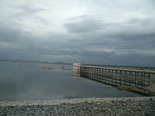
The mandal is located in forest area. A notable natural feature near the village is Kundai Waterfall.
The temple Sri Venkateswara Swamy Temple, also known as Mini Thirupathi, is located in Narnoor Mandal.

Puttaparthi is a municipality and district headquarters of Sri Sathya Sai district of the Indian state of Andhra Pradesh. It is located in Puttaparthi mandal of Puttaparthi revenue division. The original name of Puttaparthi was Gollapalli. The town is located on the banks of Chitravathi River which is a tributary of Penna River, and is surrounded by undulating hills. It is widely known for the birthplace and deathplace of the Indian spiritual leader and guru Sathya Sai Baba and his ashram, Prasanthi Nilayam.

Nizamabad or Induru is a city in the Indian state of Telangana. It is governed by municipal corporation and is the headquarters of the Nizamabad district. Although previously part of Hyderabad State and then Andhra Pradesh state, Nizamabad became a part of the newly formed state of Telangana by the Andhra Pradesh Reorganisation Act, 2014. It is located about 186 kilometres (116 mi) north of the state capital, Hyderabad.

Kovvur is a town in the East Godavari district of the Indian state of Andhra Pradesh. It is a municipality and the mandal headquarters of Kovvur mandal in Kovvur revenue division.

Nizamabad district is a district located in the north-western region of the Indian state of Telangana. The city of Nizamabad is the district headquarters. The district share boundaries with Jagtial, Sircilla, Nirmal, Kamareddy districts and with Nanded district of the state boundary of Maharashtra.

Hindupuram is a city in Sri Sathya Sai district of the Indian state of Andhra Pradesh. It is located to the edge of the Andhra–Karnataka border and is the headquarters of Hindupuram mandalam. Hindupuram is the Parliamentary Constituency in the newly formed District Sri Sathya Sai. It is located about 67 km from district headquarters Puttaparthi, 100 km from Bengaluru the capital of Karnataka, 95 km From Kadiri.
Sirpur-Kaghaznagar is a town and a municipality in Komaram Bheem Asifabad district in the state of Telangana in India. It is located about 297 kilometres from the state capital, Hyderabad, 140 kilometres from Karimnagar, 90 kms from Chandrapur and 250 kilometres from Nagpur.
Kandukur or Kandukuru is a town in SPSR Nellore district of the Indian state of Andhra Pradesh. It is a municipality and the headquarters of Kandukur mandal as well as Kandukur revenue division. Kandukur Mandal is located at the south-east side of the Prakasam District having geographical area around 225 km2.There is only 1 city in the Kandukur Mandal, which is Kandukur Municipality having an area of 37.63 km2.
Mancherial is a city and headquarters of the Mancherial district of the Indian state of Telangana. It is both the district and administrative headquarters of Mancherial mandal in the Mancherial revenue division. It is located on the north banks of the Godavari River. It is located about 244 kilometres (152 mi) from the state capital, Hyderabad, 84 kilometres (52 mi) from Karimnagar, 138 kilometres (86 mi) from Nirmal and 155 kilometres (96 mi) from Adilabad.
Punganur is a Municipality city in Chittoor district of the Indian state of Andhra Pradesh. It is the headquarters of Punganur Mandel of Palamaner Revenue Division.
Rayachoti is a Municipality and District headquarters of Annamayya district which is formed after Rajampet of the Indian state of Andhra Pradesh. Also It is the headquarters of Rayachoti revenue division. It is one of the oldest towns in Andhra Pradesh.

Wani is a 3rd largest city in Yavatmal district in the Indian state of Maharashtra.

Pakala is a town in Tirupati district of the Indian state of Andhra Pradesh. It is the mandal headquarters of Pakala mandal. It comes under Tirupati revenue division.

Bazarhathnoor is a village in Adilabad district of the Indian state of Telangana. It is located in Bazarhathnoor mandal of Adilabad revenue division. Bazarhathnoor is a mandal headquarter, 36 km (22 mi) south of its district headquarter Adilabad. Its local language is Telugu and Urdu. Bazarhathnoor total population is 4569 and number of houses are 1044. Female population is 50.2% of its total population. Baazarhathnoor's literacy rate is 55.0% and the female literacy rate is 22.5%.(2011 census). It is 299 meters above sea level. It has assembly and lok sabha constituency.
Dilawarpur is a village and mandal headquarters in Nirmal district of the India.state of Telangana.It is located about 232 kilometres north of the state capital Hyderabad, 90 kilometres from Nizamabad and 15 kilometres from the district headquarters Nirmal.[1]
Palukuru is a village in the Kandukur mandal of the Prakasam district, from the state of Andhra Pradesh, India, located 33 kilometers south of district headquarters Ongole.
Buthpur or Bhoothpur is a large area in Mahbubnagar district, Telangana.

Adilabad district is a district located in the northern region of Telangana, India. It is known as the gateway district to South and Central India. The town of Adilabad is its headquarters. The district shares boundaries with Asifabad, Nirmal districts and with the state boundary of Maharashtra.

Asifabad is a census town and the district headquarters of Kumuram Bheem district in the Indian state of Telangana. It is located in Asifabad mandal of Asifabad revenue division. It is situated on the banks of Peddavagu river. It is about 309 kilometres (192 mi) north of the state capital Hyderabad,86 kilometres (53 mi) from Ramagundam, 118 kilometres (73 mi) from Adilabad and 148 kilometres (92 mi) from Karimnagar.
Mancherial district is a district located in the northern region of the Indian state of Telangana. The district comprises 18 mandals and two revenue divisions – Mancherial and Bellampalli. The district headquarters is located at Mancherial town. It is surrounded by Komaram Bheem, Nirmal, Jagtial, Peddapalli and Bhupalpally districts of Telangana and with Maharashtra state.