
Lake Alexandrina is a freshwater lake located in the Fleurieu and Kangaroo Island and Murray Mallee regions of South Australia, adjacent to the coast of the Southern Ocean, about 100 kilometres (62 mi) south-east of Adelaide. The lake adjoins the smaller Lake Albert; together they are known as the Lower Lakes.

Lake Albert, also known by its Ngarrindjeri name, Yarli, is a notionally fresh water lake near the mouth of the Murray River in South Australia. It is filled by water flowing in from the larger Lake Alexandrina at its mouth near Narrung. It is separated on the south by the Narrung Peninsula from the salt-water Coorong. The only major town on the lake is Meningie. Lakes Alexandrina and Albert are together known as the Lower Lakes.

Murray Mouth is the point at which the River Murray meets the Southern Ocean. The Murray Mouth's location is changeable. Historical records show that the channel out to sea moves along the sand dunes over time. At times of greater river flow and rough seas, the two bodies of water would erode the sand dunes to create a new channel leaving the old one to silt and disappear.

Meningie is a town on the south-east side of Lake Albert in South Australia. It is on the Princes Highway near The Coorong and was surveyed in 1866. At the 2016 census, the locality of Meningie had a population of 1118 with a median age of 51 while its town centre had a population of 852.

Coorong is a locality in the Australian state of South Australia which is associated with the lagoon known as the Coorong in the south-east of the state and which overlooks the continental coastline from the mouth of the Murray River about 80 kilometres south-east of the state capital of Adelaide to the immediate north of the town of Kingston SE extending for a distance of at least 140 kilometres (87 mi).
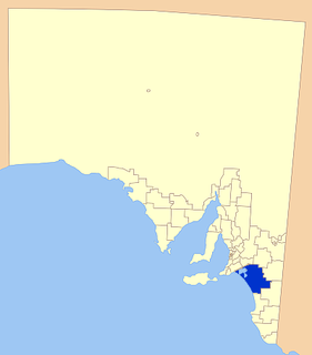
Coorong District Council is a local government area in South Australia located between the River Murray and the Limestone Coast region. The district cover mostly rural areas with small townships, as well as part of the Coorong National Park.

Clayton Bay is a town and locality in the Australian state of South Australia located on the River Murray opposite the north-east tip of Hindmarsh Island about 87 kilometres (54 mi) by road from the state capital of Adelaide and 12 kilometres (7 mi) upriver from the municipal seat of Goolwa.
Narrung is a town and locality in the Australian state of South Australia. It is situated at the northern extent of the Narrung Peninsula, which separates The Coorong from Lake Albert adjacent to The Narrows which separates Lake Albert from the larger Lake Alexandrina.

The County of Flinders is one of the 49 cadastral counties of South Australia. The county covers the southern part of the Eyre Peninsula “bounded on the north by a line connecting Point Drummond with Cape Burr, and on all other sides by the seacoast, including all islands adjacent to the main land.”

Point Sturt is a locality in the Australian state of South Australia located on the Sturt Peninsula on the west side of Lake Alexandrina about 71 kilometres (44 mi) south-east of the state capital of Adelaide and about 17 kilometres (11 mi) east of the municipal seat of Goolwa.

Goolwa South is a locality in the Australian state of South Australia located about 67 kilometres south of the state capital of Adelaide on both on the southern continental coastline and the south-western coast of Lake Alexandrina. It occupies the full extent of the Sir Richard Peninsula, land to the immediate west and part of the Goolwa Channel in the lake system to its north.
Poltalloch is a locality in the Australian state of South Australia located on land between the water bodies of Lake Alexandrina and Lake Albert about 87 kilometres south-east of the state capital of Adelaide.

The County of Russell is one of the 49 cadastral counties of South Australia. It was proclaimed in 1842 by Governor George Grey and named for Lord John Russell, who was involved with the early development of the (British) South Australian colony when he was Secretary of State for War and the Colonies. It covers a portion of the state bounded to the west by the eastern half of Lake Alexandrina and the section of the Murray River extending to Bowhill in the north and bounded to the south by the coastline adjoining the Coorong coastal lagoon and fully surrounds Lake Albert which is excluded from its extent. This includes the north western quarter of the contemporary local government area of Coorong District Council.

Loveday Bay is an inlet in the Australian state of South Australia located at the south-eastern end of Lake Alexandrina on the west coast of the Narrung Peninsula.
Lawari Conservation Park is a protected area in the Australian state of South Australia in the gazetted locality of Hindmarsh Island located at the eastern end of the island of the same name.
Meningie West is a locality in the Australian state of South Australia located in the state’s south-east about 99 kilometres (62 mi) south-east of the state capital of Adelaide and about 50 kilometres (31 mi) south-west of the municipal seat in Tailem Bend.
Mundoo Island is a locality in the Australian state of South Australia located on Mundoo Island and some adjoining water at the southern end of Lake Alexandrina about 87 kilometres (54 mi) south-east of the state capital of Adelaide.
Kyeema is a locality in the Australian state of South Australia located about 39 kilometres (24 mi) south of the state capital of Adelaide and about and 27 kilometres (17 mi) north-west of the municipal seat of Goolwa.
Carcuma is a locality in the Australian state of South Australia located about 150 kilometres (93 mi) south-east of the state capital of Adelaide and about 67 kilometres (42 mi) south-east of the municipal seat in Tailem Bend.
Coombe is a locality in the Australian state of South Australia located about 186 kilometres (116 mi) south-east of the state capital of Adelaide and about 105 kilometres (65 mi) south-east of the municipal seat in Tailem Bend.

