
East Godavari is a district in the Coastal Andhra region of Andhra Pradesh, India. Its district headquarters is at Rajamahendravaram.

Medak is a town in Medak district of the Indian state of Telangana. It is a municipality and the headquarters of Medak mandal in Medak revenue division. And There is a river named srujan which is big in length.
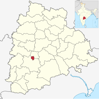
Medak district is in the Indian state of Telangana. Medak is the district headquarters. The district shares boundaries with Sangareddy, Kamareddy, Siddipet and Medchal districts.

Nizamabad district is a district located in the north-western region of the Indian state of Telangana. The city of Nizamabad is the district headquarters. The district share boundaries with Jagtial, Sircilla, Nirmal, Kamareddy districts and with Nanded district of the state boundary of Maharashtra.
Hyderabad district is a most populous district in the state of Telangana in India that contains a part of the metropolitan area of Hyderabad. It is headed by a district collector who is drawn from the IAS cadre and is appointed by the state government. It is the smallest of all the districts in the state, but has the highest human density. Old MCH area, which is central region of Hyderabad city comes under this district.The district share boundaries with Rangareddy and Medhchal districts.

Palwancha is a town in Bhadradri district of the Indian state of Telangana. It is located in Palwancha mandal of Kothagudem revenue division.
Narasapuram, or Narsapur, is a town in West Godavari district of the Indian state of Andhra Pradesh. It is a municipality and mandal headquarters of Narasapuram mandal in Narasapuram revenue division. The city is situated on the banks of the Vasista Godavari River. The lace industry is prevalent in the city and its surroundings.
Chegunta is a census town in Medak district of Telangana, has population of 10,747 of which 5,872 are males while 4,875 are females as per report released by Census India 2011. Population of Children with age of 0-6 is 655 which is 11.40% of total population of Chegunta (CT). In Chegunta Census Town, Female Sex Ratio is of 1001 against state average of 993. Moreover, Child Sex Ratio in Chegunta is around 882 compared to Andhra Pradesh state average of 939. Literacy rate of Chegunta city is 75.00% higher than state average of 67.02%. In Chegunta, Male literacy is around 86.13% while female literacy rate is 64.06%. Chegunta Census Town has total administration over 1,244 houses to which it supplies basic amenities like water and sewerage. It is also authorized to build roads within Census Town limits and impose taxes on properties coming under its jurisdiction.
Kohir Deccan is a town and Mandal headquarters in the Sangareddy district of Telangana, India. Kohir is on the Deccan Plateau in Telangana, neighbouring Karnatake state (Bidar). Kohir, Zaheerabad, Bidar, and neighbouring places brings to mind the Red Planet, and the land is usually red roads, red stones on streets with red houses made of red soil and black soil in agriculture land. Kohir was named after the distinctive red soil of the region. Kohir in local slang means "red diamond". The "Pati Matti" once mixed with water turns into very strong material fit for construction of multistoried buildings. These mud houses are unbreakable and can withstand even the harsh climate of this region. Kohir is bounded by Zahirabad, Jharasangam and Munpalle mandals of Sangareddy district and Rangareddy district.
Regode is a village and Mandal in Medak district of Telangana, India.
Nyalkal is a village in Medak district of Telangana, India.
Nagapuram is a village in Medak district of the Indian state of Telangana. It is located in Medak mandal of Medak revenue division.
Narsapur Assembly constituency is a constituency of Telangana Legislative Assembly, India. It is one of 10 constituencies in Medak district. It is part of Medak Lok Sabha constituency.
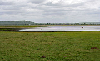
Medak mandal is one of the 46 mandals in Medak district of the Indian state of Telangana. It is under the administration of Medak revenue division and the headquarters are located at Medak. The mandal is bounded by Ramayampet, Shankarapet (R), Kulcharam, Papannapet mandals and a portion of it also borders Nizamabad district.

Kamareddy district is a district located in the northern region of the Indian state of Telangana. The district shares boundaries with Medak, Nizamabad, Sangareddy, Siddipet and Rajanna Sircilla districts and with the state boundary of Maharashtra and Karnataka.

Siddipet district is a district located in the northern region of the Indian state of Telangana. Its headquarters is Siddipet. This district contains a part of the Hyderabad Metropolitan Region(Markook Mulugu Wargal) The district shares boundaries with Jangaon, Sircilla, Karimnagar, Kamareddy, Hanamkonda, Yadadri, Medhchal and Medak districts.

Kowdipally is a small town Mandal in the Medak district of the Indian state of Telangana. It is represents the headquarters of the Kowdipally Mandal.

Konaseema district is one of the 26 districts in the Indian state of Andhra Pradesh. It is situated between the tributaries of the Godavari river in the Konaseema region of Coastal Andhra. It was carved out of East Godavari district on 4 April 2022 by the Government of Andhra Pradesh. Amalapuram is the district headquarters and the largest city in this district. Other significant towns in the district are Mandapeta, Ramachandrapuram, and Mummidivaram.
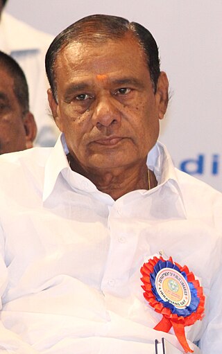
Chilumula Madan Reddy is a politician from the Indian state of Telangana. He is currently representing the Bharat Rashtra Samithi as an MLA from Narsapur Assembly constituency.

Chilipched is a village in Chilipched Mandal, Medak District, Telangana, India.


