Between 57.3 and 59.5 latitude and 21.5 and 28.1 longitude, Estonia lies on the eastern shores of the Baltic Sea on the level northwestern part of the rising East European Platform. It borders the Gulf of Finland, between Latvia and Russia. Average elevation reaches 50 m (164 ft).

The Gulf of Finland is the easternmost arm of the Baltic Sea. It extends between Finland to the north and Estonia to the south, to Saint Petersburg in Russia to the east, where the river Neva drains into it. Other major cities around the gulf include Helsinki and Tallinn. The eastern parts of the Gulf of Finland belong to Russia, and some of Russia's most important oil harbors are located farthest in, near Saint Petersburg. As the seaway to Saint Petersburg, the Gulf of Finland has been and continues to be of considerable strategic importance to Russia. Some of the environmental problems affecting the Baltic Sea are at their most pronounced in the shallow gulf.

Iguazú Falls or Iguaçu Falls are waterfalls of the Iguazu River on the border of the Argentine province of Misiones and the Brazilian state of Paraná. Together, they make up the largest waterfall in the world. The falls divide the river into the upper and lower Iguazu. The Iguazu River rises near the heart of the city of Curitiba. For most of its course, the river flows through Brazil; however, most of the falls are on the Argentine side. Below its confluence with the San Antonio River, the Iguazu River forms the border between Argentina and Brazil.
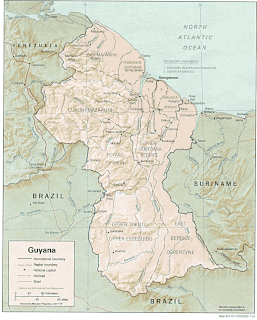
The Geography of Guyana comprises the physical characteristics of the country in Northern South America and part of Caribbean South America, bordering the North Atlantic Ocean, between Suriname and Venezuela, with a land area of approximately 214,969 square km. The country is situated between 1 and 9 north latitude and between 56 and 62 west longitude. With a 459 km (285 mi)-long Atlantic coastline on the northeast, Guyana is bounded by Venezuela on the west, Brazil on the west and south, and Suriname on the east.

Narva is a municipality and city in Estonia. It is located in Ida-Viru County, at the eastern extreme point of Estonia, at the Russian border, on the Narva River which drains Lake Peipus. The city of Narva is the country's third largest after Tallinn and Tartu.

Lake Peipus (Estonian: Peipsi-Pihkva järv; Russian: Псковско-Чудское озеро, romanized: Pskovsko-Chudskoye ozero; is the largest trans-boundary lake in Europe, lying on the border between Estonia and Russia.

Harju County, is one of the fifteen counties of Estonia. It is situated in Northern Estonia, on the southern coast of the Gulf of Finland, and borders Lääne-Viru County to the east, Järva County to the southeast, Rapla County to the south, and Lääne County to the southwest. The capital and largest city of Estonia, Tallinn, is situated in Harju County. Harju County is the largest county in Estonia in terms of population, as almost half (45%) of the Estonia's population lives in Harju County.

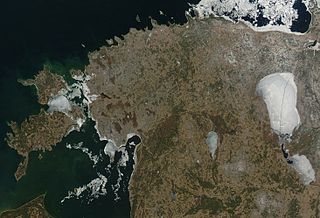
The river Narva, formerly also Narova flows 77 kilometres (48 mi) north into the Baltic Sea and is the largest Estonian river by discharge. A similar length of land far to the south, together with it and a much longer intermediate lake, altogether forms the Estonia-Russia border.

The Battle of Narva was a military campaign between the German Army Detachment "Narwa" and the Soviet Leningrad Front fought for possession of the strategically important Narva Isthmus on 2 February – 10 August 1944 during World War II.
The Sinimäed Hills are three linked hills in northeastern Estonia. The heights which are aligned west-east, consist of Tornimägi, Põrguaugu mägi and Pargimägi. They lie in Narva-Jõesuu municipality near the coastal town of Sillamäe in Ida-Viru County.

The Narva Power Plants are a power generation complex in and near Narva in Estonia, near the border with Leningrad Oblast, Russia. The complex consists of the world's two largest oil shale-fired thermal power plants, Eesti Power Plant and Balti Power Plant. In 2007, Narva Power Plants generated about 95% of total power production in Estonia. The complex is owned and operated by AS Narva Elektrijaamad, a subsidiary of Eesti Energia.

Lasnamäe is the most populous administrative district of Tallinn, the capital of Estonia. The district's population is about 119,000, the majority of which is Russian-speaking. Local housing is mostly represented by 5–16 stories high panel blocks of flats, built in the 1970–1990s.
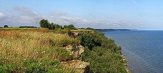
The Baltic Klint is an erosional limestone escarpment and cuesta on several islands of the Baltic Sea, in Estonia, in Leningrad Oblast of Russia and in the islands of Gotland and Öland of Sweden. It was featured on the reverse of the 50 krooni note of 1928 and on the 100 krooni note of 1992.

Pakri Islands are two Estonian islands in the Finnish Gulf: Suur-Pakri and Väike-Pakri. Administratively they belong to the town of Paldiski. For centuries the islands had been inhabited by Estonian Swedes, until during the Second World War the entire population was forced to leave.

This is a sub-article to Battle of Narva (1944).
The Narva offensive was an operation conducted by the Soviet Leningrad Front. It was aimed at the conquest of the Narva Isthmus from the German army detachment "Narwa". At the time of the operation, Joseph Stalin, the supreme commander of the Soviet Armed Forces, was personally interested in taking Estonia, viewing it as a precondition to forcing Finland out of the war.
This is a sub-article to Battle of Narva.

Kreenholm is a river island in Estonia, located in the Narva River, within the city limits of Narva.
The Kreenholm Manufacturing Company was a textile manufacturing company located on the island of Kreenholm in Narva, Estonia, on the border with Russia. It is situated along the banks of the Narva River, by the Narva Falls; the Baltic Sea is approximately 10 miles (16 km) away, and there is a distance of 75 miles (121 km) to Saint Petersburg. It was founded by Ludwig Knoop, a cotton merchant from Bremen. At one point, the company's cotton spinning and manufacturing mills were the largest in the world; and Kreenholm was considered in its time to be the most important mill in Russia, owning 32,000 acres of land and employing 12,000 people. Throughout its history, the company faced different obstacles such as the possibility of closure after World War I. In 1994, it was privatized after Estonia regained independence. The company went bankrupt in 2010, but continued limited operations after purchase by a new owner.

