In aviation, visual flight rules (VFR) are a set of regulations under which a pilot operates an aircraft in weather conditions generally clear enough to allow the pilot to see where the aircraft is going. Specifically, the weather must be better than basic VFR weather minima, i.e., in visual meteorological conditions (VMC), as specified in the rules of the relevant aviation authority. The pilot must be able to operate the aircraft with visual reference to the ground, and by visually avoiding obstructions and other aircraft.

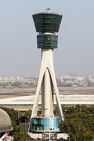
Air traffic control (ATC) is a service provided by ground-based air traffic controllers who direct aircraft on the ground and through a given section of controlled airspace, and can provide advisory services to aircraft in non-controlled airspace. The primary purpose of ATC is to prevent collisions, organize and expedite the flow of traffic in the air, and provide information and other support for pilots.

Air traffic control specialists, abbreviated ATCs, are personnel responsible for the safe, orderly, and expeditious flow of air traffic in the global air traffic control system. Usually stationed in air traffic control centers and control towers on the ground, they monitor the position, speed, and altitude of aircraft in their assigned airspace visually and by radar, and give directions to the pilots by radio. Controllers apply separation rules to keep aircraft at a safe distance from each other and within proper airspace in their area of responsibility and move all aircraft safely and efficiently through their assigned sector of airspace, as well as on the ground. Because controllers have an incredibly large responsibility while on duty and make countless real-time decisions on a daily basis, the ATC profession is consistently regarded around the world as one of the most mentally challenging careers, and can be notoriously stressful depending on many variables. Many controllers, however, cite high salaries, and a large, unique, and privileged degree of autonomy as major advantages of their jobs.
Aviation is the design, development, production, operation, and use of aircraft, especially heavier-than-air aircraft. Articles related to aviation include:
Airspace is the portion of the atmosphere controlled by a country above its territory, including its territorial waters or, more generally, any specific three-dimensional portion of the atmosphere. It is not the same as outer space which is the expanse or space outside the Earth and aerospace which is the general term for Earth's atmosphere and the outer space within the planet's vicinity.
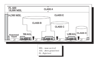
The world's navigable airspace is divided into three-dimensional segments, each of which is assigned to a specific class. Most nations adhere to the classification specified by the International Civil Aviation Organization (ICAO) and described below, though they might use only some of the classes defined below, and significantly alter the exact rules and requirements. Similarly, individual nations may also designate special use airspace (SUA) with further rules for reasons of national security or safety.

Canadian airspace is the region of airspace above the surface of the Earth within which Canada has jurisdiction. It falls within a region roughly defined as either the Canadian land mass, the Canadian Arctic or the Canadian archipelago, and areas of the high seas. Airspace is managed by Nav Canada and detailed information regarding exact dimensions and classification is available in the Designated Airspace Handbook which is published every fifty-six days by Nav Canada.

In air traffic control, an area control center (ACC), also known as a center or en-route center, is a facility responsible for controlling aircraft flying in the airspace of a given flight information region (FIR) at high altitudes between airport approaches and departures. In the US, such a center is referred to as an air route traffic control center (ARTCC).

An airport surveillance radar (ASR) is a radar system used at airports to detect and display the presence and position of aircraft in the terminal area, the airspace around airports. It is the main air traffic control system for the airspace around airports. At large airports it typically controls traffic within a radius of 60 miles (96 km) of the airport below an elevation of 25,000 feet. The sophisticated systems at large airports consist of two different radar systems, the primary and secondary surveillance radar. The primary radar typically consists of a large rotating parabolic antenna dish that sweeps a vertical fan-shaped beam of microwaves around the airspace surrounding the airport. It detects the position and range of aircraft by microwaves reflected back to the antenna from the aircraft's surface. The secondary surveillance radar consists of a second rotating antenna, often mounted on the primary antenna, which interrogates the transponders of aircraft, which transmits a radio signal back containing the aircraft's identification, barometric altitude, and an emergency status code, which is displayed on the radar screen next to the return from the primary radar.

In aviation, a non-towered airport is an airport without a control tower, or air traffic control (ATC) unit. In the United States, there are close to 20,000 non-towered airports compared to approximately 500 airports with control towers. Airports with a control tower without 24/7 ATC service follow non-towered airport procedures when the tower is closed but the airport remains open, for example at night.

Special use airspace (SUA) is a type of special airspaces in the United States designated for operations of a nature such that limitations may be imposed on aircraft not participating in those operations. Often these operations are of a military nature. The designation of SUAs identifies for other users the areas where such activity occurs, provides for segregation of that activity from other users, and allows charting to keep airspace users informed of potential hazards.

The United States airspace system's classification scheme is intended to maximize pilot flexibility within acceptable levels of risk appropriate to the type of operation and traffic density within that class of airspace – in particular to provide separation and active control in areas of dense or high-speed flight operations.
The Philadelphia TRACON/ATCT is located at the Philadelphia International Airport and is a TRACON with Up-and-Down capabilities which means it includes both a TRACON and ATCT in the same facility. The facility is "sectorized" into two sectors for the controllers. "A-side" controllers, work the tower, and half the radar room. "B-side" controllers work the entire radar room (POM).

The Boston Consolidated TRACON (A90) is located in Merrimack, New Hampshire. A90 opened in 2004 after 8 years of development. The A90 function transferred to the new Boston Consolidated TRACON on February 22, 2004. The MHT function transferred over on March 7, 2004. Manchester TRACON used to be located at Manchester Airport below the old ATCT. Boston TRACON used to be located at the Logan International Airport Control Tower before being consolidated. The new facility is 63,000 square feet (5,900 m2). A Terminal Radar Approach Control, or TRACON, is responsible for descending airplanes from the ARTCC and lining them up for landing at their destination airport, as well as climbing departures before handing off to the ARTCC.
ATC Zero is an official term used by the U.S. Federal Aviation Administration (FAA) that means the FAA is unable to safely provide the published ATC services within the airspace managed by a specific facility. The term is always used in conjunction with a facility reference. FAA ATC facilities include Air Route Traffic Control Centers (ARTCC); Terminal Radar Control facility (TRACON), Air Traffic Control Tower (ATCT), Flight Service Stations (FSS), or the Air Traffic Control System Command Center (ATCSCC). The term is defined in FAA Order JO 1900.47, Air Traffic Control Operational Contingency Plans. It is one of three designations used by the FAA to describe degraded operations and invoke operational contingency plans.

The Los Angeles Air Route Traffic Control Center is an air traffic control center located in Palmdale, California, United States. Located adjacent to United States Air Force Plant 42 and the Palmdale Regional Airport, it is one of 22 Air Route Traffic Control Centers (ARTCC) operated by the United States Federal Aviation Administration (FAA).

The Air Traffic Organization (ATO) is an air navigation service provider in the United States of America. The ATO is the operational division of the Federal Aviation Administration (FAA).

On August 8, 2009, at 11:53 a.m. (15:53 UTC), nine people died when a tour helicopter and a small private airplane collided over the Hudson River near Frank Sinatra Park in Hoboken, New Jersey, United States. The aircraft were in an area known as the "Hudson River VFR Corridor", which extends from the surface of the river to altitudes of 800 to 1,500 ft at various locations along the Hudson River in the immediate area of New York City. Within this corridor, aircraft operate under visual flight rules (VFR), under which the responsibility to see and avoid other air traffic rests with the individual pilots rather than with the air traffic controller (ATC).

Anchorage Air Route Traffic Control Center (PAZA/ZAN) is an Area Control Center operated by the Federal Aviation Administration just outside the main gate of Joint Base Elmendorf-Richardson at 700 North Boniface Parkway in Anchorage, Alaska, United States. The Anchorage ARTCC is one of 22 Air Route Traffic Control Centers in the United States.
The Cape TRACON (K90) is a radar approach facility located at Joint Base Cape Cod, Massachusetts next to the airfield for Coast Guard Air Station Cape Cod. It is operated by the Federal Aviation Administration (FAA).


