Related Research Articles

Ground transport in the Democratic Republic of the Congo (DRC) has always been difficult. The terrain and climate of the Congo Basin present serious barriers to road and rail construction, and the distances are enormous across this vast country. Furthermore, chronic economic mismanagement and internal conflict has led to serious under-investment over many years.

The Pool Malebo, formerly Stanley Pool, also known as Mpumbu, Lake Nkunda or Lake Nkuna by local indigenous people in pre-colonial times, is a lake-like widening in the lower reaches of the Congo River. The river serves as the border between the Republic of the Congo to the north and the Democratic Republic of the Congo to the south.

North Kivu is a province bordering Lake Kivu in the eastern Democratic Republic of the Congo. Its capital is Goma.

South Kivu is one of 26 provinces of the Democratic Republic of the Congo (DRC). Its capital is Bukavu.

Bukavu is a city in eastern Democratic Republic of the Congo (DRC), lying at the extreme south-western edge of Lake Kivu, west of Cyangugu in Rwanda, and separated from it by the outlet of the Ruzizi River. It is the capital of the South Kivu Province and as of 2012 it had an estimated population of 806,940.

Kisangani is the capital of Tshopo province in the Democratic Republic of the Congo. It is the fifth most populous urban area in the country, with an estimated population of 1,312,000 in 2021, and the largest of the cities that lie in the tropical woodlands of the Congo.
The Kinshasa Highway is an informal name for a route across the Democratic Republic of the Congo into Uganda and beyond, consisting of paved highways in some places and seasonally impassable tracks in others. The name has gained currency for the role which long-distance truck drivers played in the early spread of AIDS in the 1980s. Although there is a paved road from Kinshasa to Kikwit and a little beyond, and there are paved roads between Kisangani, Bukavu, Kampala and Nairobi, there has never been a paved highway across the centre of the Congo joining Kinshasa and Kikwit to Bukavu. Neither is there any coordinating authority for a 'Kinshasa Highway' or 'Autoroute de Kinshasa'.

The term Mai-Mai or Mayi-Mayi refers to any kind of community-based militia group active in the Democratic Republic of the Congo (DRC) that is formed to defend local communities and territory against other armed groups. Most were formed to resist the invasion of Rwandan forces and Rwanda-affiliated Congolese rebel groups, but some may have formed to exploit the war to their own advantage by looting, cattle rustling or banditry.

Goma is the capital of North Kivu province in the eastern Democratic Republic of the Congo. It is located on the northern shore of Lake Kivu, next to the Rwandan city of Gisenyi. The lake and the two cities are in the Albertine Rift, the western branch of the East African Rift system. Goma lies only 13–18 km (8.1–11.2 mi) south of the active Nyiragongo Volcano. The recent history of Goma has been dominated by the volcano and the Rwandan genocide of 1994, which in turn fueled the First and Second Congo Wars. The aftermath of these events was still having effects on the city and its surroundings in 2010. The city was captured by rebels of the March 23 Movement during the M23 rebellion in late 2012, but it has since been retaken by government forces.

The Alliance of Democratic Forces for the Liberation of Congo-Zaire was a coalition of Rwandan, Ugandan, Burundian, and Congolese dissidents, disgruntled minority groups, and nations that toppled Mobutu Sese Seko and brought Laurent-Désiré Kabila to power in the First Congo War. Although the group was successful in overthrowing Mobutu, the alliance fell apart after Kabila did not agree to be dictated by his foreign backers, Rwanda and Uganda, which marked the beginning of the Second Congo War in 1998.
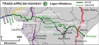
The Lagos–Mombasa Highway or TAH 8 is Trans-African Highway 8 and is the principal road route between West and East Africa. It has a length of 6,259 km (3,889 mi) and is contiguous with the Dakar-Lagos Highway with which it will form the longest east-west crossing of the continent for a total distance of 10,269 km (6,381 mi). Its main importance at the moment is connecting West Africa with Southern Africa via Yaoundé and Gabon because the section through the Democratic Republic of the Congo is unpaved and difficult.

Masisi Territory is a territory which is located within the North Kivu Province of the Democratic Republic of the Congo. Its political headquarters are located in the town of Masisi.
Walikale Territory is a territory located within the Congolese province of North Kivu, in the eastern regions of the Democratic Republic of the Congo. The headquarters are in the town of Walikale. The locality is situated between Bukavu and Lubutu on DR Congo National Road No. 3 in the valley of the river Lowa, 135 km to the west of Goma.
The Congolese Rally for Democracy, also known as the Rally for Congolese Democracy, is a political party and a former rebel group that operated in the eastern region of the Democratic Republic of the Congo (DRC). It was supported by the government of Rwanda, and was a major armed faction in the Second Congo War (1998-2003). It became a social liberal political party in 2003.
The Land Forces, also called the Congolese Army, are the land warfare component and the largest branch of the Armed Forces of the Democratic Republic of the Congo (FARDC).

On 30 June or 2 July 2014, the Armed Forces of the Democratic Republic of the Congo and United Nations forces launched an offensive against rebel groups in the Masisi and Walikale territories, part of the North Kivu province, in the eastern Democratic Republic of the Congo (DRC).
The following is a timeline of the history of the city of Bukavu, Democratic Republic of the Congo.
The Mbarara–Kisangani Road is a road in Uganda and the Democratic Republic of the Congo, connecting the cities of Mbarara and Mpondwe in Uganda to Kasindi, Beni, Komanda and Kisangani in the Democratic Republic of the Congo.
Busengo is a settlement in the North Kivu Province of the Democratic Republic of the Congo. The town sits across the international border from Busengo, Uganda.
The Bwito Chiefdom is a traditional administrative unit located in the Rutshuru Territory of North Kivu Province in the Democratic Republic of the Congo (DRC). It is one of the chiefdoms within Rutshuru Territory, bordered to the north by Batangi Chiefdom in Lubero Territory, Bwisha Chiefdom in the east, and to the north-east by Lake Edward and the Republic of Uganda. To the west, it is bordered by Bashali-Mokoto Chiefdom in Masisi Territory, and to the northwest by Wanyanga Chiefdom in Walikale Territory. To the south, it is bordered by Nyiragongo Territory.
References
- 1 2 République démocratique du Congo, Ministère des Infrastructures, Travaux publics et Reconstruction, Cellule Infrastructures (2016). Sectionnement de la Route Nationale 3 (PDF).
- ↑ "Kisangani - Democratic Republic of the Congo". Encyclopedia Britannica. 20 July 1998. Retrieved 21 March 2023.
- ↑ Vogt, Silvia (9 July 2006). "Congo's Roads Paved With Hope: Repaired Route Helps Country Rebuild After Years of War, Political Turmoil". The Washington Post . Archived from the original on 27 August 2017. Retrieved 5 March 2023.
- ↑ "Kongo: Straßenbau schafft Einkommen" [Congo: Road construction generates income] (in German). Deutsche Welthungerhilfe e.V. Archived from the original on 31 July 2010. Retrieved 5 March 2023.
- ↑ Centre, UNESCO World Heritage (9 July 2011). "World Heritage in the Congo Basin". UNESCO World Heritage Centre. Retrieved 21 March 2023.
| | This Democratic Republic of the Congo location article is a stub. You can help Wikipedia by expanding it. |