
Ground transport in the Democratic Republic of the Congo (DRC) has always been difficult. The terrain and climate of the Congo Basin present serious barriers to road and rail construction, and the distances are enormous across this vast country. Furthermore, chronic economic mismanagement and internal conflict has led to serious under-investment over many years.

North Kivu is a province bordering Lake Kivu in the eastern Democratic Republic of the Congo. Its capital is Goma.

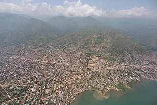
Bukavu is a city in eastern Democratic Republic of the Congo (DRC), lying at the extreme south-western edge of Lake Kivu, west of Cyangugu in Rwanda, and separated from it by the outlet of the Ruzizi River. It is the capital of the South Kivu Province and as of 2012 it had an estimated population of 806,940.

Goma is the capital of North Kivu province in the eastern Democratic Republic of the Congo. It is located on the northern shore of Lake Kivu, next to the Rwandan city of Gisenyi. The lake and the two cities are in the Albertine Rift, the western branch of the East African Rift system. Goma lies only 13–18 km (8.1–11.2 mi) south of the active Nyiragongo Volcano. The recent history of Goma has been dominated by the volcano and the Rwandan genocide of 1994, which in turn fueled the First and Second Congo Wars. The aftermath of these events was still having effects on the city and its surroundings in 2010. The city was captured by rebels of the March 23 Movement during the M23 rebellion in late 2012, but it has since been retaken by government forces.
Uvira is the capital city of the Uvira Territory in the South Kivu Province of the Democratic Republic of the Congo (DRC). It is situated between Lake Tanganyika and the Mitumba Mountains and covers an area of approximately 16km.
The Vodacom Ligue 1 is the top division of the Congolese Association Football Federation, the governing body of football in the Democratic Republic of the Congo. It was created in 1958. In 2013, the highest attendance was set in the match DC Motema Pembe - AS Vita Club, which saw an attendance of 80,000 football fans at Stade des Martyrs. TP Mazembe is the most successful club with 19 titles.
Articles related to the Democratic Republic of the Congo include:

The National Assembly is the lower house and main legislative political body of the Parliament of the Democratic Republic of the Congo. It is one of the two legislative bodies along with the Senate. The National Assembly is composed of deputies who are elected by the citizens of the DRC. The deputies serve as the voice of the people and are responsible for enacting legislation, representing their constituents' interests, and overseeing the executive branch of government. The National Assembly is responsible for deliberating and passing laws that impact the nation and its citizens. It was established by the 2006 constitution, which provided for a bicameral parliament consisting of the National Assembly and the Senate. It is located at the People's Palace in Kinshasa.

Walikale Territory is a territory located within the Congolese province of North Kivu, in the eastern regions of the Democratic Republic of the Congo. The headquarters are in the town of Walikale. The locality is situated between Bukavu and Lubutu on DR Congo National Road No. 3 in the valley of the river Lowa, 135 km to the west of Goma.
Army General Gabriel Amisi Kumba was Chief of Staff of the Forces Terrestres, the army of the Democratic Republic of the Congo. Amisi was a former Forces armees Zairoises (FAZ) officer who was recruited into the Alliance of Democratic Forces for the Liberation of Congo (AFDL) in 1996. During the Second Congo War, Amisi was assistant chief of staff for logistics of the Rally for Congolese Democracy (RCD-G). This position was the origin of his nickname, as T-4 was the abbreviation for his position. He was implicated by Human Rights Watch in the execution of soldier Joe Lona Bifuko and in the torture of prisoners in the ANC military intelligence detention centre in Goma in 2001.
Kanyabayonga is one of the groupements (groupings) within the Bwito Chiefdom in the Rutshuru Territory of North Kivu Province in the eastern Democratic Republic of the Congo (DRC). The region has suffered from continued violence between the army and rival militias since 1993.

Uvira Territory is a territory in South Kivu, Democratic Republic of the Congo. It is bordered by Walungu Territory to the north, Mwenga Territory to the west, Fizi Territory to the south, and Burundi and Lake Tanganyika to the east. Its capital is Uvira.
The following is a timeline of the history of the city of Bukavu, Democratic Republic of the Congo.
The following is a timeline of the history of the city of Goma, Democratic Republic of the Congo.

Mamadou Mustafa Ndala was a colonel in the Armed Forces of the Democratic Republic of the Congo.
Juwe Kazimbe Joyeux, better known as Joyeux Bin Kabodjo, is a Congolese humorist, comedian, storyteller, poet and jurist.

National Road No. 1 is a major highway in the Democratic Republic of the Congo. It runs from the western port of Banana though the cities of Kinshasa, Kananga, Mbuji-Mayi, Lubumbashi, and ends at Kasumbalesa in the southeast of the country where it connects with the T3 road in Zambia. The road contains the Matadi Bridge, the largest bridge in the country, which spans the Congo River.
The Bwito Chiefdom is a traditional administrative unit located in the Rutshuru Territory of North Kivu Province in the Democratic Republic of the Congo (DRC). It is one of the chiefdoms within Rutshuru Territory, bordered to the north by Batangi Chiefdom in Lubero Territory, Bwisha Chiefdom in the east, and to the north-east by Lake Edward and the Republic of Uganda. To the west, it is bordered by Bashali-Mokoto Chiefdom in Masisi Territory, and to the northwest by Wanyanga Chiefdom in Walikale Territory. To the south, it is bordered by Nyiragongo Territory.

