Notes
This article includes a list of references, related reading, or external links, but its sources remain unclear because it lacks inline citations .(May 2015) |
The Natural Area Reserves System (NARS) of Hawaii is a statewide attempt to preserve in perpetuity specific land and water areas which support communities, as relatively unmodified as possible, of the natural flora and fauna, as well as geological sites, of Hawaii.
Established in 1970 by Hawaii Revised Statutes Chapter 195, the system presently consists of 19 reserves on five islands, encompassing more than 109,000 acres (440 km2) of the State's ecosystems. The diverse areas found in the NARS range from marine and coastal environments to lava flows, tropical rainforests, and even an alpine desert. Within these areas one can find rare endemic plants and animals, many of which are on the edge of extinction.
The Natural Area Reserves System is administered by the Department of Land and Natural Resources, Division of Forestry and Wildlife. Currently, management teams are working to control the encroachment of non-native plants and animals which threaten the existence of the natural biota on the reserves.
The reserves include:
This article includes a list of references, related reading, or external links, but its sources remain unclear because it lacks inline citations .(May 2015) |

Hawaii is the largest island in the United States, located in the eponymous state of Hawaii. It is the southeasternmost of the Hawaiian Islands, a chain of volcanic islands in the North Pacific Ocean. With an area of 4,028 square miles (10,430 km2), it has 63% of the Hawaiian archipelago's combined landmass. However, it has only 13% of the archipelago's population. The island of Hawaiʻi is the third largest island in Polynesia, behind the north and south islands of New Zealand.

Mauna Loa is one of five volcanoes that form the Island of Hawaii in the U.S. state of Hawaii in the Pacific Ocean. Mauna Loa is Earth's largest active volcano by both mass and volume. It was historically considered to be the largest volcano on Earth until Tamu Massif was discovered to be larger. Mauna Loa is a shield volcano with relatively gentle slopes, and a volume estimated at 18,000 cubic miles (75,000 km3), although its peak is about 125 feet (38 m) lower than that of its neighbor, Mauna Kea. Lava eruptions from Mauna Loa are silica-poor and very fluid, and tend to be non-explosive.

Mauna Kea is an inactive shield volcano on the island of Hawaiʻi. Its peak is 4,207.3 m (13,803 ft) above sea level, making it the highest point in Hawaii and second-highest peak of an island on Earth. The peak is about 38 m (125 ft) higher than Mauna Loa, its more massive neighbor. Mauna Kea is unusually topographically prominent for its height: its wet prominence is fifteenth in the world among mountains, at 4,205 m (13,796 ft); its dry prominence is 9,330 m (30,610 ft). This dry prominence is greater than Mount Everest's height above sea level of 8,848.86 m (29,032 ft), and some authorities have labeled Mauna Kea the tallest mountain in the world, from its underwater base. Mauna Kea is ranked 8th by topographic isolation.

The Mauna Kea Observatories (MKO) are a group of independent astronomical research facilities and large telescope observatories that are located at the summit of Mauna Kea on the Big Island of Hawaiʻi, United States. The facilities are located in a 525-acre (212 ha) special land use zone known as the "Astronomy Precinct", which is located within the 11,228-acre (4,544 ha) Mauna Kea Science Reserve. The Astronomy Precinct was established in 1967 and is located on land protected by the Historical Preservation Act for its significance to Hawaiian culture. The presence and continued construction of telescopes is highly controversial due to Mauna Kea's centrality in native Hawaiian religion and culture, as well as for a variety of environmental reasons.

Kīlauea is an active shield volcano in the Hawaiian Islands. It is located along the southeastern shore of Hawaii Island. The volcano is between 210,000 and 280,000 years old and grew above sea level about 100,000 years ago. Since the islands were settled it has been the most active of the five volcanoes that together form the island.

Hualālai is an active volcano on the island of Hawaiʻi in the Hawaiian Islands. It is the westernmost, third-youngest and the third-most active of the five volcanoes that form the island of Hawaiʻi, following Kīlauea and the much larger Mauna Loa. Its peak stands 8,271 feet (2,521 m) above sea level. Hualālai is estimated to have risen above sea level about 300,000 years ago. Despite maintaining a very low level of activity since its last eruption in 1801, and being unusually inactive for the last 2,000 years, Hualālai is still considered active, and is expected to erupt again sometime in the next 100 years. The relative unpreparedness of the residents in the area caused by the lull in activity would worsen an eruption's consequences.

Kohala is the oldest of five volcanoes that make up the island of Hawaii. Kohala is an estimated one million years old—so old that it experienced, and recorded, the reversal of Earth's magnetic field 780,000 years ago. It is believed to have breached sea level more than 500,000 years ago and to have last erupted 120,000 years ago. Kohala is 606 km2 (234 sq mi) in area and 14,000 km3 (3,400 cu mi) in volume, and thus constitutes just under 6% of the island of Hawaii.

Route 200, known locally as Saddle Road, traverses the width of the Island of Hawaiʻi, from downtown Hilo to its junction with Hawaii Route 190 near Waimea. The road was once considered one of the most dangerous paved roads in the state, with many one-lane bridges and areas of marginally maintained pavement. Most of the road has now been repaved, and major parts have new re-alignments to modern standards. The highway is mostly one-lane in each direction, but there are two lanes on the uphill portions. The highway reaches a maximum elevation of 6,632 feet (2,021 m) and is subject to fog and low visibility. Many rental car companies used to prohibit use of their cars on Saddle Road, but now allow use of the road. The highway experiences heavy use as it provides the shortest driving route from Hilo to Kailua-Kona and access to the slopes of Mauna Loa and the Mauna Kea Observatories.
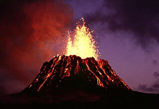
Puʻu ʻŌʻō is a volcanic cone on the eastern rift zone of Kīlauea volcano in the Hawaiian Islands. The eruption that created Puʻu ʻŌʻō began on January 3, 1983, and continued nearly continuously until April 30, 2018, making it the longest-lived rift-zone eruption of the last two centuries.

Puna is one of the 9 districts of Hawaii County on the Island of Hawaiʻi. It is located on the windward side of the island and shares borders with South Hilo district in the north and Kaʻū district in the west. With a size of just under 320,000 acres (1,300 km2) or 500 sq. miles, Puna is slightly smaller than the island of Kauaʻi.

A heiau is a Hawaiian temple. Made in different architectural styles depending upon their purpose and location, they range from simple earth terraces, to elaborately constructed stonen platforms. There are heiau to treat the sick, offer first fruits, offer first catch, start rain, stop rain, increase the population, ensure the health of the nation, achieve success in distant voyaging, reach peace, and achieve success in war (luakini).

Hāmākua is a district on the northeast coast of Hawaiʻi's Big Island, administered by the County of Hawaiʻi in the state of Hawaiʻi. It is also the name given for the coastline in the region, the "Hāmākua Coast".

Lake Waiau is a high-elevation lake located at 3,970 m (13,020 ft) above sea level on Mauna Kea, on the island of Hawaiʻi. It is arguably one of the highest lakes in the United States. After the evaporation of Ka Wai o Pele in 2018 and the short-lived lake in Halema'uma'u crater in 2020, Lake Waiau is the only lake on Hawaiʻi Island and one of very few lakes at all in the state of Hawaiʻi. It is relatively small, only about 100 m across, and varies in size as the water level rises and falls. At high water levels a small outlet stream appears at the northwest end, but it is absorbed into the ground after a short distance. The name means "swirling water" in Hawaiian, though it is usually rather placid. It usually freezes in winter, but aquatic insects such as midges and beetles can be found breeding in the water.

Pōhakuloa Training Area (PTA) is a US military training base located on the high plateau between Mauna Loa, Mauna Kea and the Hualālai volcanic mountains of the island of Hawaiʻi. It includes a small military airstrip known as Bradshaw Army Airfield.
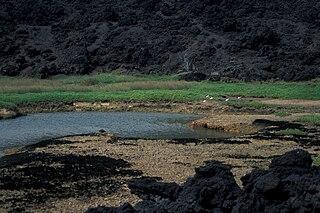
Established in 1973, ʻĀhihi-Kīnaʻu Natural Area Reserve includes a coastal lava field and surrounding waters on the southwest coast of the island of Maui, Hawaii. It consists of 1,238 acres (501 ha) on land and 807 acres (327 ha) of ocean along 3 miles (4.8 km) of Maui's southwestern coastline. The reserve includes several popular snorkeling/diving sites and many cultural and geologic sites as well as habitat for numerous rare and endangered species. The purpose and intent of the Reserve is to preserve and protect three unique components: the geologic setting of the most recent lava flow on Maui; unique assemblages of nearshore coral reef ecosystems; and the anchialine ponds found there.

The Mauna Kea Trail, also known as the Humuʻula Trail, is a hiking route leading from the Onizuka Center for International Astronomy to the summit of Mauna Kea, the highest volcano on the island of Hawaiʻi.

The Mauna Kea Ice Age Natural Area Reserve is a Hawaii state natural reserve that includes the Mauna Kea Adz Quarry, on the southern slope of Mauna Kea on the island of the Hawaiʻi.

Puʻu Huluhulu is a volcanic cone located near the center of the Island of Hawaii in the State of Hawaii. It is located on the southern side of Hawaii Route 200, directly across from the highway's intersection with the Mauna Kea Access Road. Puʻu Huluhulu is Hawaiian for hairy hill.
The Hawaiian wild cattle are a feral breed of domestic cattle introduced at the end of 18th century. Thousands of them are still freely roaming forested areas on the Island of Hawaiʻi. It was listed as "extinct" in The State of the World's Animal Genetic Resources for Food and Agriculture, published by the FAO in 2007; it is not among the cattle breeds reported to DAD-IS by the National Animal Germplasm Program of the USDA Agricultural Research Service.