Related Research Articles

Navigation is a field of study that focuses on the process of monitoring and controlling the movement of a craft or vehicle from one place to another. The field of navigation includes four general categories: land navigation, marine navigation, aeronautic navigation, and space navigation.

A sextant is a doubly reflecting navigation instrument that measures the angular distance between two visible objects. The primary use of a sextant is to measure the angle between an astronomical object and the horizon for the purposes of celestial navigation.

A compass is a device that shows the cardinal directions used for navigation and geographic orientation. It commonly consists of a magnetized needle or other element, such as a compass card or compass rose, which can pivot to align itself with magnetic north. Other methods may be used, including gyroscopes, magnetometers, and GPS receivers.

Celestial navigation, also known as astronavigation, is the practice of position fixing using stars and other celestial bodies that enables a navigator to accurately determine their actual current physical position in space or on the surface of the Earth without relying solely on estimated positional calculations, commonly known as dead reckoning. Celestial navigation is performed without using satellite navigation or other similar modern electronic or digital positioning means.

In navigation, bearing or azimuth is the horizontal angle between the direction of an object and north or another object. The angle value can be specified in various angular units, such as degrees, mils, or grad. More specifically:
The basic principles of air navigation are identical to general navigation, which includes the process of planning, recording, and controlling the movement of a craft from one place to another.
Piloting or pilotage is the process of navigating on water or in the air using fixed points of reference on the sea or on land, usually with reference to a nautical chart or aeronautical chart to obtain a fix of the position of the vessel or aircraft with respect to a desired course or location. Horizontal fixes of position from known reference points may be obtained by sight or by radar. Vertical position may be obtained by depth sounder to determine depth of the water body below a vessel or by altimeter to determine an aircraft's altitude, from which its distance above the ground can be deduced. Piloting a vessel is usually practiced close to shore or on inland waterways. Pilotage of an aircraft is practiced under visual meteorological conditions for flight.
The backstaff is a navigational instrument that was used to measure the altitude of a celestial body, in particular the Sun or Moon. When observing the Sun, users kept the Sun to their back and observed the shadow cast by the upper vane on a horizon vane. It was invented by the English navigator John Davis, who described it in his book Seaman's Secrets in 1594.

The octant, also called a reflecting quadrant, is a reflecting instrument used in navigation.

The history of navigation, or the history of seafaring, is the art of directing vessels upon the open sea through the establishment of its position and course by means of traditional practice, geometry, astronomy, or special instruments. Many peoples have excelled as seafarers, prominent among them the Austronesians, the Harappans, the Phoenicians, the Iranians, the ancient Greeks, the Romans, the Arabs, the ancient Indians, the Norse, the Chinese, the Venetians, the Genoese, the Hanseatic Germans, the Portuguese, the Spanish, the English, the French, the Dutch, and the Danes.
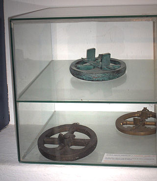
The mariner's astrolabe, also called sea astrolabe, was an inclinometer used to determine the latitude of a ship at sea by measuring the sun's noon altitude (declination) or the meridian altitude of a star of known declination. Not an astrolabe proper, the mariner's astrolabe was rather a graduated circle with an alidade used to measure vertical angles. They were designed to allow for their use on boats in rough water and/or in heavy winds, which astrolabes are ill-equipped to handle. It was invented by the Portuguese people, a nation known for its maritime prowess that dominated the sea for multiple centuries. In the sixteenth century, the instrument was also called a ring.

A quadrant is an instrument used to measure angles up to 90°. Different versions of this instrument could be used to calculate various readings, such as longitude, latitude, and time of day. Its earliest recorded usage was in ancient India in Rigvedic times by Rishi Atri to observe a solar eclipse. It was then proposed by Ptolemy as a better kind of astrolabe. Several different variations of the instrument were later produced by medieval Muslim astronomers. Mural quadrants were important astronomical instruments in 18th-century European observatories, establishing a use for positional astronomy.
Reflecting instruments are those that use mirrors to enhance their ability to make measurements. In particular, the use of mirrors permits one to observe two objects simultaneously while measuring the angular distance between the objects. While reflecting instruments are used in many professions, they are primarily associated with celestial navigation as the need to solve navigation problems, in particular the problem of the longitude, was the primary motivation in their development.

An Elton's quadrant is a derivative of the Davis quadrant. It adds an index arm and artificial horizon to the instrument, and was invented by English sea captain John Elton, who patented his design in 1728 and published details of the instrument in the Philosophical Transactions of the Royal Society in 1732.

A mathematical instrument is a tool or device used in the study or practice of mathematics. In geometry, construction of various proofs was done using only a compass and straightedge; arguments in these proofs relied only on idealized properties of these instruments and literal construction was regarded as only an approximation. In applied mathematics, mathematical instruments were used for measuring angles and distances, in astronomy, navigation, surveying and in the measurement of time.

Throughout the early Age of Exploration, it became increasingly clear that the residents of the Iberian Peninsula were experts at navigation, sailing, and expansion. From Henry the Navigator's first adventures down the African coast to Columbus's fabled expedition resulting in the discovery of the new world, the figures that catalyzed the European appetite for expansion and imperialism heralded from either Portugal or Spain. However, merely a century earlier, nautical travel for most peoples was resigned to keeping within sight of a coastline and very rarely did ships venture out into deeper waters. The period's ships were not able to handle the forces of open ocean travel and the crewmen had neither the ability nor the necessary materials to keep themselves from getting lost. A sailor's ability to travel was dictated by the technology available, and it was not until the late 15th century that the development of the nautical sciences on the Iberian Peninsula allowed for the genesis of long-distance shipping by directly effecting, and leading to the creation of, new tools and techniques relative to navigation. Christopher Columbus’s famous expedition, which crossed the ocean in 1492, was arguably the first contact the civilized world had with the newly discovered continent. Financed and sponsored by Queen Isabella of Spain, his journey would open the door to new trading lanes, imperialist appetites, and the meeting of cultures. Portugal and Spain became the world's foremost leaders in deep water navigation and discovery because of their sailing expertise and the advancement of nautical sciences benefiting their ability to sail further, faster, more accurately, and safer than other states. Vast amounts of precious minerals and lucrative slaves were poured into Iberian treasuries between the late 15th and mid to late 17th centuries because of Spanish and Portuguese domination of Atlantic trade routes. The golden age of Portugal and Spain was a direct result of the advancements made in navigation technology and the sciences which allowed for deep water sailing.
Spencer, Browning & Rust was a London firm that manufactured instruments for navigational use during the 18th and 19th centuries. The predecessor company of Spencer and Browning was established by William Spencer and Samuel Browning in 1778, before they entered into partnership with Ebenezer Rust in 1784. After the death of Ebenezer Rust's son, the successor business was known as Spencer, Browning & Co. The firm of Spencer, Browning & Rust made a variety of navigational instruments, including octants and sextants.
Jonathan Sisson was an English instrument maker, the inventor of the modern theodolite with a sighting telescope for surveying, and a leading maker of astronomical instruments.
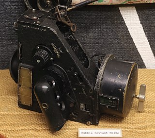
The bubble octant and bubble sextant are air navigation instruments. Although an instrument may be called a "bubble sextant", it may actually be a bubble octant.
References
- ↑ Li, Kun(LElectronic Travel Aids for Blind Guidanceinda). Sutardja Center for Entrepreneurship & Technology, Berkeley, California, 2015, pp. 1–10, Electronic Travel Aids for Blind Guidance.
- ↑ Patra, Rusha, et al. “(PDF) an Electronic Travel Aid for Navigation of Visually Impaired Persons.” ResearchGate, Feb. 2011, https://www.researchgate.net/publication/224219996_An_electronic_travel_aid_for_navigation_of_visually_impaired_persons.