
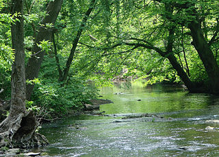
Naylors Run is a 4.6-mile-long (7.4 km) [1] tributary of Cobbs Creek in Haverford and Upper Darby Township, Pennsylvania, United States. [2]
Naylors Run is a 4.6-mile-long (7.4 km) [1] tributary of Cobbs Creek in Haverford and Upper Darby Township, Pennsylvania, United States. [2]
In 1975, a small dam was built near Naylors Run Park to help control flooding. [3]
Naylors Run flows underground in Upper Darby from Sherbrook Boulevard to Walnut Park Drive, where it joins Cobbs Creek. Thousands of feet of Naylors Run were channeled into underground culverts to facilitate commercial and residential development in the filled land above the pipes. [4] Naylors Run joins Cobbs Creek near 63rd st and Cedar Lane.
Naylors Run would normally be an intermittent stream, but it has become a perennially flowing stream because of the treated water discharged from the Havertown PCP Superfund water treatment facility. [5]
The Havertown PCP Superfund site severely polluted Naylors Run. National Wood Preservers (NWP) operated a wood preservation treatment plant at the intersection of Eagle Road and West Hillcrest Avenue in Havertown from 1947 to 1991. [6] During its operations, chemicals used to treat wood and waste products were dumped into a well on the property. [7] These chemicals fed directly into Naylors Run. [8]
In 1962, the Pennsylvania Department of Health discovered pollution leaking into Naylors Run and attributed it to NWP's waste disposal practices after receiving complaints from local residents about an oily substance being discharged from a sewer pipe. [6] Analysis of water samples from Naylors Creek measured pentachlorophenol (PCP) concentrations of 0.5 parts per million (ppm). Concentrations of PCP at 0.2 ppm are lethal to fish. [9] The Environmental Protection Agency (EPA) ranked the Havertown PCP Superfund site the eighth worst cleanup project in the United States. [10]
In 1976, the Environmental Protection Agency (EPA) initiated clean-up action under section 311 of the Clean Water Act. They installed filter fences to remove PCP contaminated oil from the surface water of Naylors Run. They sealed a sanitary sewer pipe and attempted to seal a storm sewer drain but contaminants continued to drain directly into Naylors Run. [11]
From 1981 to 1983, the EPA conducted an investigation to determine the level of contamination of Naylors Run. It was believed that 90% of the PCP released into the stream had been absorbed into the sediment and could potentially act as a secondary source of contamination. At the EPA's recommendation, NWP posted signs along Naylors Run to warn about the health risks. [5]
In 1987, the EPA tested samples from nine locations in Naylors Run and detected contaminants such as arsenic, benzo(a)anthracene, benzo(a)pyrene, dioxin and PCP. [11]
In 1989, the EPA installed a catch-basin and oil/water separator for the storm drain effluent into Naylors Run. The oil/water separator was removed after installation of recovery wells and a water treatment facility at the main contamination site in 2001. [5]
In 2008, the EPA determined that sediment and surface water in Naylors Run did not contain contaminants from the Havertown PCP Superfund site in excess of EPA risk levels. They did however determine that the stream contained other chemicals in excess of EPA risk levels from sources other than the Superfund site. [5]
Remediation and monitoring efforts are ongoing and the EPA transferred control of the superfund site to the Pennsylvania Department of Environmental Protection in 2013. [7] The site was deemed to be "short-term protective of human health and the environment" in the sixth five-year report conducted by the EPA in 2020. [6]

The Duwamish River is the name of the lower 12 miles (19 km) of Washington state's Green River. Its industrialized estuary is known as the Duwamish Waterway. Although heavily polluted, it is an important habitat for the wildlife. Important to the Duwamish people, the Duwamish Longhouse and Cultural Center is on the west bank of the river and several parks have indigenous Lushootseed names.

Superfund is a United States federal environmental remediation program established by the Comprehensive Environmental Response, Compensation, and Liability Act of 1980 (CERCLA). The program is administered by the Environmental Protection Agency (EPA) and is designed to pay for investigating and cleaning up sites contaminated with hazardous substances. Sites managed under this program are referred to as Superfund sites. Of the tens of thousands of sites selected for possible action under the Superfund program, 1178 remain on the National Priorities List (NPL) that makes them eligible for cleanup under the Superfund program. Sites on the NPL are considered the most highly contaminated and undergo longer-term remedial investigation and remedial action (cleanups). The state of New Jersey, the fifth smallest state in the U.S., is the location of about ten percent of the priority Superfund sites, a disproportionate amount.
Darby Creek is a tributary of the Delaware River in Chester, Delaware and Philadelphia counties, in the U.S. Commonwealth of Pennsylvania. It is approximately 26 miles (42 km) long. The watershed of the creek has an area of 77.2 square miles (200 km2). It has twelve named direct tributaries, including Cobbs Creek, Little Darby Creek, Ithan Creek, and Muckinipattis Creek. The creek has a low level of water quality for most of its length. The lower Darby Creek area was deemed a Superfund site by the U.S. Environmental Protection Agency (EPA) due to contamination with dangerous chemicals from two landfills.
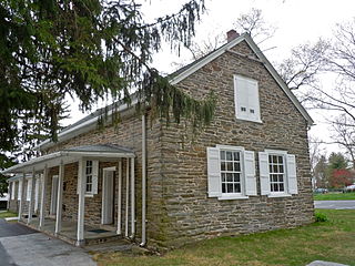
Havertown is a residential suburban unincorporated community in Haverford Township, Pennsylvania, United States. It is located approximately 9 miles west of the center of Philadelphia. Havertown's ZIP Code is 19083 and "Havertown" is a postal address. The name "Havertown" was coined by the U.S. Post Office and came into use on January 1, 1946. Before then, each constituent community was known by its local name: Bon Air, Brookline, Penfield, Beechwood, Llanerch, Manoa, Oakmont, Coopertown, and Ardmore. Under William Penn's land divisions these communities were part of the Welsh Tract.
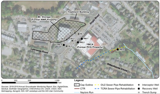
Havertown Superfund is a 13-acre polluted groundwater site in Havertown, Pennsylvania contaminated by the dumping of industrial waste by National Wood Preservers from 1947 to 1991. The state first became aware of the pollution in 1962 and initiated legal action against the owners in 1973 to force them to cleanup the site. The Environmental Protection Agency (EPA) ranked the site the eighth worst cleanup project in the United States. The site was added to the National Priorities List in 1983 and designated as a Superfund cleanup site in the early 1990s. Remediation and monitoring efforts are ongoing and the EPA transferred control of the site to the Pennsylvania Department of Environmental Protection in 2013.
The American Creosote Works Superfund site is an inactive wood-treating facility in Pensacola, Florida. The 18-acre site is located about 600 yards north of the confluence of Bayou Chico and Pensacola Bay at 701 S "J" Street. The Superfund program of the United States Environmental Protection Agency (EPA) is responsible for cleaning up the nation's most contaminated land and responding to environmental emergencies, oil spills, and natural disasters.
Wade Dump was a rubber recycling facility and illegal industrial waste storage and disposal facility in Chester, Pennsylvania. It was located at 1 Flower Street on the western bank of the Delaware River just north of the Commodore Barry Bridge.
The Escambia Wood Treating Company (ETC) site is located at 3910 Palafox Highway, northeast of the intersection of Fairfield Drive in Pensacola, Florida, and is in a mixed industrial, commercial, and residential area. The site includes the 26-acre property of the former wood preserving facility and over 60 acres of nearby neighborhoods. The facility was in operation from 1942 until 1982, then abandoned by the owner in 1991. During its operation, ETC treated utility poles, foundation pilings, and lumber with creosote and pentachlorophenol. Production byproducts were dumped into on-site, unlined containment pits where they seeped into the surrounding soil and groundwater.

The BoRit Asbestos Superfund site is a 32-acre (13 ha) waste dump and reservoir in Ambler, Upper Dublin Township and Whitpain Township, Pennsylvania that was contaminated with 1.5 million cubic yards of asbestos containing material due to the waste disposal practices of the Keasbey and Mattison (K&M) Company and Turner and Newall from 1897 to 1962. The site is named BoRit after Bob Rittenhouse, one of the recent owners of the site.
The Capitol City Plume, which also is referred to as the Capital City Plume, is an area of contaminated groundwater located beneath the western downtown area of Montgomery, Alabama. The contamination was discovered in 1993 by the Alabama Department of Environmental Management (ADEM) which was investigating soil contamination at the Retirement Systems of Alabama Energy Plant in the city. After assessment by the United States Environmental Protection Agency (EPA) it was proposed for inclusion in the National Priorities List (NPL) in May 2000.
The Atlas Asbestos Mine Superfund Site is located within the Clear Creek Management Area near Fresno County, eighteen miles northwest of Coalinga, California. The mine started operating in 1963, covering 435 acres of a large naturally occurring asbestos deposit. The mine closed in 1979 and was placed in the EPA's National Priorities List (NPL) in 1983 due to the pollution of asbestos in the surrounding soil, air and water creating potential health hazards for local populations and environment.

The Koppers Co., Inc. (KCI) Superfund Site is one of three Superfund sites in Oroville, California, along with Louisiana Pacific Sawmill and Western Pacific Railyard. The KCI Superfund Site is a 200-acre site which served as a wood treatment plant for 50 years. Wood was treated with many chemicals to prevent wood deterioration. The accumulation of these chemicals from spills, fires, and uses has caused this site to be contaminated with the hazardous waste material. Due to soil and groundwater contamination, the site was placed on the National Priorities List in 1984 for remedial action plans to clean up the site to protect surrounding residential areas concerning environmental and human health risks.

Silver Bow Creek is a 26-mile-long (42 km) headwater stream of the Clark Fork (river) originating within the city limits of Butte, Montana, from the confluence of Little Basin and Blacktail Creeks. A former northern tributary, Yankee Doodle Creek, no longer flows directly into Silver Bow Creek as it is now captured by the Berkeley Pit. Silver Bow Creek flows northwest and north through a high mountain valley, passing east of Anaconda, Montana, where it becomes the Clark Fork at the confluence with Warm Springs Creek.

The California Gulch site consists of approximately 18 square miles in Lake County, Colorado. The area includes the city of Leadville, parts of the Leadville Historic Mining District and a section of the Arkansas River from the confluence of California Gulch downstream to the confluence of Two-Bit Gulch. The site was listed as a Superfund site in 1983.

Moyer's Landfill was a privately owned landfill in Collegeville, Pennsylvania, United States. It was originally farmland outside the town. In the 1940s, the owner started accepting trash and municipal waste as a way to make additional money. The original landfill was 39 acres and did not have a liner to protect the land from contaminate. A liner was added to a new section in the late 1970s. Over time, the landfill accepted sewage, and industrial wastes which contained hazardous substances in addition to municipal waste. The site was closed by the EPA in 1981, and was one of the first "Superfund" sites added to the National Priorities List.
The Dewey Loeffel Landfill is an EPA superfund site located in Rensselaer County, New York. In the 1950s and 1960s, several companies including General Electric, Bendix Corporation and Schenectady Chemicals used the site as a disposal facility for more than 46,000 tons of industrial hazardous wastes, including solvents, waste oils, polychlorinated biphenyls (PCBs), scrap materials, sludges and solids. Some hazardous substances, including volatile organic compounds (VOCs) and PCBs, have migrated from the facility to underlying aquifers and downstream surface water bodies, resulting in contamination of groundwater, surface water, sediments and several species of fish. There is currently a ban on fish consumption in Nassau Lake and the impacted tributaries. Following prior assessments and attempts at mitigating drainage from the site, the Environmental Protection Agency (EPA) has placed the site on its National Priority List. As of 2024, the EPA reports ongoing site investigations.
Bog Creek Farm, located in Howell Township, New Jersey, is a designated Environmental Protection Agency (EPA) Superfund site. Lying on 12 acres of land, Bog Creek Farm is home to several hazardous and life-threatening contamination beginning in 1973 and continuing for a year. Over a decade later, actions began to take place to clean and restore the contaminated soil and water. Bog Creek Farm is situated near several other farms that house horses, growing crops and flowers, and livestock. Less than a mile down the road lies Allaire State Park, a park used by golfers, hunters, and fisherman.
The CPS Madison Industries Superfund Site is located in Old Bridge, New Jersey. Since 1967, site operators had improperly handed high-risk substances by expelling them into public sewer systems throughout the township. Established in 1962, CPS Madison Industries, located in Middlesex County, New Jersey, has remained a large competitor in the copper and zinc industry producing compounds primarily for food additives, fertilizers, and pharmaceuticals. CPS Madison Industries was declared to be a superfund site as of September 8, 1983, due to its improper handlings of Volatile Organic Compounds, and has since been undergoing groundwater pump and treatment systems since 1991.

Ohio River Park is a Superfund Site located in Neville Island, Pennsylvania. Between the 1920s-1970s, the Site was used for municipal waste, pesticide manufacturing, coke sludge disposal, cement manufacturing disposal, and pesticide waste. In 1977, Neville Land Company donated the Site to Allegheny County who started developing the Site as a community park. In 1979, Allegheny County found various hazardous contaminants on the Site. On August 30, 1990, the Site was determined to be a Superfund Site due to VOCs, SVOCs, inorganics, and pesticides being present in the surface soil, subsurface soil, surface water, river sediment, and groundwater. Soil remediation began in February 1998 and ended in September 1999. Today, Ohio River Park has the Robert Morris University Island Sports Center and Coraopolis Bridge on top of it. Additionally, benzene continues to be monitored because it is still present in the Site's groundwater.

The Dubose Oil Products Company was located near Highway C97 in the Cantonment, Florida area.