Related Research Articles

A cave or cavern is a natural void under the Earth's surface. Caves often form by the weathering of rock and often extend deep underground. Exogene caves are smaller openings that extend a relatively short distance underground. Caves which extend further underground than the opening is wide are called endogene caves.
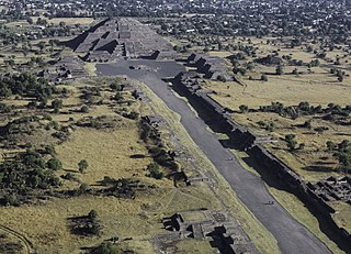
Teotihuacan is an ancient Mesoamerican city located in a sub-valley of the Valley of Mexico, which is located in the State of Mexico, 40 kilometers (25 mi) northeast of modern-day Mexico City.

Mesoamerican chronology divides the history of prehispanic Mesoamerica into several periods: the Paleo-Indian ; the Archaic, the Preclassic or Formative (2500 BCE – 250 CE), the Classic (250–900 CE), and the Postclassic (900–1521 CE); as well as the post European contact Colonial Period (1521–1821), and Postcolonial, or the period after independence from Spain (1821–present).

Tehuacán is the second largest city in the Mexican state of Puebla, nestled in the southeast of the valley of Tehuacán, bordering the states of Oaxaca and Veracruz. The 2010 census reported a population of 248,716 in the city and 274,906 in the surrounding Tehuacán municipality, of which it serves as municipal seat. The municipality has an area of 390.36 km2 (150.72 sq mi).
Joljaʼ is an archaeological site of the pre-Columbian Mayan civilization, located in the Chiapas highlands of central southern Mexico. Also known as Cueva de Jolja' in Spanish, the site is a cave which contains a painted mural and a number of inscriptions in the Mayan script which date back to the Early Classic period.

Chalcatzingo is a Mesoamerican archaeological site in the Valley of Morelos dating from the Formative Period of Mesoamerican chronology. The site is well known for its extensive array of Olmec-style monumental art and iconography. Located in the southern portion of the Central Highlands of Mexico, Chalcatzingo is estimated to have been settled as early as 1500 BCE. The inhabitants began to produce and display Olmec-style art and architecture around 900 BCE. At its height between 700 BCE and 500 BCE, Chalcatzingo's population is estimated at between five hundred and a thousand people. By 500 BCE it had gone into decline. The climate in Morelos is generally warmer and more humid than the rest of the Highlands. The Chalcatzingo center covers roughly 100 acres (0.40 km2). Evidence indicates that this was a site of ritual significance.
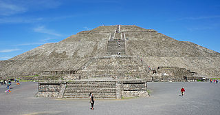
The Pyramid of the Sun is the largest building in Teotihuacan, and one of the largest in Mesoamerica. It is believed to have been constructed about 200 CE. Found along the Avenue of the Dead, in between the Pyramid of the Moon and the Ciudadela, and in the shadow of the mountain Cerro Gordo, the pyramid is part of a large complex in the heart of the city.

Dos Ojos is part of a flooded cave system located north of Tulum, on the Caribbean coast of the Yucatán Peninsula, in the state of Quintana Roo, Mexico. The exploration of Dos Ojos began in 1987 and still continues. The surveyed extent of the cave system is 82 kilometers (51 mi) and there are 28 known sinkhole entrances, which are locally called cenotes. In January 2018, a connection was found between Sistema Dos Ojos and Sistema Sac Actun. The smaller Dos Ojos became a part of Sac Actun, making the Sistema Sac Actun the longest known underwater cave system in the world.
The Mayan architecture of the Maya civilization spans across several thousands of years, several eras of political change, and architectural innovation before the Spanish colonization of the Americas. Often, the buildings most dramatic and easily recognizable as creations of the Maya peoples are the step pyramids of the Terminal Preclassic Maya period and beyond. Based in general Mesoamerican architectural traditions, the Maya utilized geometric proportions and intricate carving to build everything from simple houses to ornate temples. This article focuses on the more well-known pre-classic and classic examples of Maya architecture. The temples like the ones at Palenque, Tikal, and Uxmal represent a zenith of Maya art and architecture. Through the observation of numerous elements and stylistic distinctions, remnants of Maya architecture have become an important key to understanding their religious beliefs and culture as a whole.

The Oparara Basin Arches are a number of natural limestone tunnels formed by the Oparara River, in the Oparara Basin, New Zealand. The two most famous ones are the 'Oparara Arch', large enough for a multi-storey house, and the 'Moria Gate Arch', which is smaller in height.
JuxtlahuacaSpanish pronunciation:[xuʃtɬaˈwaka] is a cave and archaeological site in the Mexican state of Guerrero containing murals linked to the Olmec motifs and iconography. Along with the nearby Oxtotitlán cave, Juxtlahuaca walls contain the earliest sophisticated painted art known in Mesoamerica, and only known example of non-Maya deep cave art in Mesoamerica.

Oxtotitlán is a natural rock shelter and archaeological site in Chilapa de Álvarez, Mexican state of Guerrero that contains murals linked to the Olmec motifs and iconography. Along with the nearby Juxtlahuaca cave, the Oxtotitlán rock paintings represent the "earliest sophisticated painted art known in Mesoamerica", thus far. Unlike Juxtlahuaca, however, the Oxtotitlán paintings are not deep in a cave system but rather occupy two shallow grottos on a cliff face.
Mayan cave sites are associated with the Mayan civilization of pre-Columbian Mesoamerica. Beliefs and observances connected with these cave sites persist among some contemporary Mayan communities. Many of the Mayan caves served religious purposes. For this reason, the artifacts found there, alongside the epigraphic, iconographic, and ethnographic studies, help build the modern-day understanding of the Mayan religion and society.

The Castellana Caves are a karst cave system located in the municipality of Castellana Grotte, in the Metropolitan City of Bari, Apulia, southern Italy.

The Balsas River is a major river of south-central Mexico.
Coxcatlan Cave is a Mesoamerican archaeological site in the Tehuacán Valley, State of Puebla, Mexico. It was discovered by Richard MacNeish in the 1960s during a survey of the Tehuacán Valley. It was the initial appearance of three domesticated plants in the Tehuacan Valley that allowed an evaluation to be done again of the overall temporal context of the plant domestication in Mexico. In addition to plants, Coxcatlan Cave also provided nearly 75 percent of the classified stone tools from excavation.

Coliboaia Cave is located in Apuseni Natural Park, Câmpani, Bihor County, Romania. It may contain the oldest known cave paintings of Central Europe, radiocarbon dated to 32,000 and 35,000 years BP, corresponding to the Aurignacian and Gravettian cultures of the Paleolithic period.

Sistema Huautla is a cave system in the Sierra Mazateca mountains of the southern Mexican state of Oaxaca. As of April 2021 it is the deepest cave system in the Western Hemisphere, 1,560 metres (5,120 ft) from top to bottom, with over 55 miles of mapped passageways. It is the tenth deepest cave in the world. It is also the 26th longest cave system with over 100 km length.
The Archaic period, also known as the preceramic period, is a period in Mesoamerican chronology that begins around 8000 BCE and ends around 2000 BCE and is generally divided into Early, Middle, and Late Archaic periods. The period is preceded by the Paleoindian period and followed by the Preclassic period. Scholars have found it difficult to determine exactly when the Paleoindian period ends and the Archaic begins, but it is generally linked with changing climate associated with the transition from the Pleistocene to the Holocene epochs, and absence of extinct Pleistocene animals. It is also generally unclear when the Archaic period ends and the Preclassic period begins, though the appearance of pottery, large-scale agriculture, and villages signal the transition.
The Archaic period is traditionally viewed as a long, transitional interval between the hunter-gatherers of the Paleoindian period and the proliferation of agricultural villages in the Preclassic. This period is known for the domestication of major Mesoamerican crops, the development of agriculture, and the beginning of sedentism. The major developments in agriculture and sedentism during this time allowed for the rise of complex societies in the region. These developments were not uniform throughout Mesoamerica and often differed regionally.
References
- Brady, James E.; Keith M. Prufer, eds. (2005). In the Maw of the Earth Monster:Studies of Mesoamerican Ritual Cave Use. Austin: University of Texas Press. ISBN 0-292-70586-7.