

This is a list of caves in Mexico (not just archaeological):
This is a list of caves in Mexico (not just archaeological):

Quintana Roo, officially the Free and Sovereign State of Quintana Roo, is one of the 31 states which, with Mexico City, constitute the 32 federal entities of Mexico. It is divided into 11 municipalities, and its capital city is Chetumal.

The Riviera Maya is a tourism and resort district south of Cancun, Mexico. It straddles the coastal Federal Highway 307, along the Caribbean coastline of the state of Quintana Roo, located in the eastern portion of the Yucatán Peninsula. Originally the name applied narrowly, focusing on the area of coastline between the city of Playa del Carmen and Tulum. The designation has since expanded up and down the coast, now including the towns of Puerto Morelos, situated to the north of Playa del Carmen, as well as the town of Felipe Carrillo Puerto, situated 40 km (25 mi) to the south of Tulum. This larger region is what is currently being promoted as part of the Riviera Maya tourist corridor.

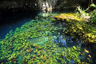
A cenote is a natural pit, or sinkhole, resulting from the collapse of limestone bedrock that exposes groundwater. The term originated on the Yucatán Peninsula of Mexico, where cenotes were commonly used for water supplies by the ancient Maya, and occasionally for sacrificial offerings. The term derives from a word used by the lowland Yucatec Maya—tsʼonoʼot—to refer to any location with accessible groundwater.

Dos Ojos is part of a flooded cave system located north of Tulum, on the Caribbean coast of the Yucatán Peninsula, in the state of Quintana Roo, Mexico. The exploration of Dos Ojos began in 1987 and still continues. The surveyed extent of the cave system is 82 kilometers (51 mi) and there are 28 known sinkhole entrances, which are locally called cenotes. In January 2018, a connection was found between Sistema Dos Ojos and Sistema Sac Actun. The smaller Dos Ojos became a part of Sac Actun, making the Sistema Sac Actun the longest known underwater cave system in the world.
Sistema Nohoch Nah Chich, is located 16.5 kilometers (10.3 mi) south of Akumal in Tulum Municipality of Quintana Roo state, southeastern Mexico. It is part of the Sistema Sac Actun underwater cave systems.
Sistema Ox Bel Ha is a cave system in Quintana Roo, Mexico. It is the longest explored underwater cave in the world and ranks second including dry caves. As of January 2023 the surveyed length is 435.8 kilometers (270.8 mi) of underwater passages. There are more than 150 cenotes in the system.
Sistema Sac Actun is an underwater cave system situated along the Caribbean coast of the Yucatán Peninsula with passages to the north and west of the city of Tulum. Discovery of a connection to Sistema Dos Ojos in 2018 made it the longest known underwater cave system. As of January 2023, it is the second longest underwater cave system in the world, only surpassed by Sistema Ox Bel Ha.
The Quintana Roo Speleological Survey (QRSS) was established in 1990 for the safe exploration, survey and cartography of the underwater and dry caves and cenotes of Quintana Roo, Mexico, supported by the National Speleological Society.

The following outline is provided as an overview of and topical guide to Mexico:
Most Mexican states do not have an official flag. For these states, a de facto flag is used for civil and state purposes. State flags of Mexico have a 4:7 ratio and typically consist of a white background charged with the state's coat of arms.
Televisa Regional is a unit of Grupo Televisa which owns and operates television stations across Mexico. The stations rebroadcast programming from its subsidiary TelevisaUnivision's other networks, and they engage in the local production of newscasts and other programs. Televisa Regional stations all have their own distinct branding, except for those that are Nu9ve affiliates and brand as "Nu9ve <city/state name>".
Cacahuaziziqui is a pre-Columbian cave site containing Olmec paintings. It is located in the Mexican state of Guerrero on the southern coast of the country. The site is located 30 miles west of Oxtotitlan and Juxtlahuaca and southeast of Tlapa, a mountainous area in Guerrero. The Guerrero caves are often located in remote canyons.

Charles William (Bill) Steele, Jr. is a cave explorer and speleologist who has led and participated in expeditions to many of the longest and deepest caves in the USA, Mexico, and China. He has explored more than 2,500 caves across North America and Asia and has written two books chronicling his expeditions: Yochib: The River Cave, and Huautla: Thirty Years in One of the World's Deepest Caves. TV shows such as National Geographic Explorer, NOVA and How’d They Do That? have aired programs on his expeditions.
The following television stations broadcast on digital channel 23 in Mexico:
The following television stations broadcast on digital channel 25 in Mexico:
The following television stations broadcast on digital channel 28 in Mexico:
The following television stations broadcast on digital or analog channel 22 in Mexico:
The following television stations operate on virtual channel 4 in Mexico:
The biosphere reserves of Mexico are protected natural areas. Some are designated by the national government, while others are internationally designated by UNESCO.
| Authority control databases: National |
|---|