Grutas de Cacahuamilpa National Park

Last updated
Grutas de Cacahuamilpa National Park
Mexico relief location map.jpg
Red pog.svg
Location Guerrero / Morelos, Mexico
Nearest city Taxco, Guerrero
Coordinates 18°40′11″N99°30′36″W / 18.66962°N 99.50991°W / 18.66962; -99.50991 Coordinates: 18°40′11″N99°30′36″W / 18.66962°N 99.50991°W / 18.66962; -99.50991
Area1,600 hectares (4,000 acres)
EstablishedApril 23, 1936 [1]
Governing body Secretariat of the Environment and Natural Resources

The Grutas de Cacahuamilpa National Park in Guerrero, Mexico, is best known for the Grutas de Cacahuamilpa Caverns. It is also home to the Grutas of Carlos Pacheco, a smaller system, as well as two subterranean rivers which have carved out tunnels in the rock. [2] The park has outdoor pursuit attractions such as rappelling, and rock climbing in Limontitla Canyon. [2] as well as the two underground rivers to explore. It also has a small botanical garden, a pool and places to camp. [3]

Contents

Geography

The park is located in the Sierra Madre del Sur mountains, primarily in the northeast part of Guerrero state. This section of the Sierra Madre del Sur is made of rock, mostly limestone, that was formed under oceans millions of years ago. The caverns extend through the municipalities of Pilcaya, Tetipac and Taxco of Guerrero state, and extend into Morelos state in the municipality of Coatlán del Río. [4] The parks extends over 2,700 hectares of land, [5] and is located southwest of Mexico City, near the silversmithing town of Taxco. [3]

This is the well-known cave system in Mexico, and popular for caving. [4] [6] The park is visited by about 350,000 people annually, generating an income of about 8 million pesos each year. [7]

Grutas de Cacahuamilpa

One of the formations in the Grutas de Cacahuamilpa 09Cacahuamilpa.JPG
One of the formations in the Grutas de Cacahuamilpa
Passing through one of the salons of the caverns 59Cacahuamilpa.JPG
Passing through one of the salons of the caverns
One of the main corridors of the caves GrutasCacahuamilpa.jpg
One of the main corridors of the caves

Cacahuamilpa is one of the largest cave systems in the world. [4] It is a "live" cave system, meaning that groundwater still filters down into it, and that the formations there are still growing. [3] Inside the cavern system are ninety large "salons" separated by large natural rock walls and connected to one another via a central gallery. [4] However, only about twenty of these are fully explored and open to the public. [8] Most of these salons are located under the Cerro de la Corona, a limestone mountain ridge. [6] The publicly-open portion is essentially a two-km-long, level passage of linked “salons” or borehole openings. [4] These salons average about forty meters wide, [6] and vary in height from twenty to 81 meters. [2] Most have names which reflect the major formations found in them such as the Goat Salon, the Throne Salon and the Cathedral Salon. [4] All the openings numerous rock formations growing from both the ceiling and the floor. [4] [6] One of the drier salons has been dubbed the “Auditorium”. It has a large flat floor and has been outfitted with seats. It is rented out for events, [2] and has been the site for a number of concerts including one in 2007 by Miguel Bosé [9] and one by the Acapulco Philharmonic Orchestra in 2009. [10]

Tours of the open cave system run every hour and last about two hours. [3] On the walkway to the entrance there are a couple of amate trees (Ficus insipida) with their roots wound around the rocky walls of Limontitla Canyon. [11] The entrance is a large arch about forty meters wide and twelve meters tall. From the entrance, one descends about twenty meters to the level of the caverns. The path has a mostly level cement walkway, and there is artificial illumination on both the path and parts of the salons. However, since it is a live cave, the high humidity can make the trek uncomfortable for some people. [4]

At least parts of the cave system have been known for centuries, and parts have been occupied since pre-Hispanic times. Excavations in the caverns have produced fragments of pottery. [6] This area was home to the Olmec people, and later the Chontal tribe. Both peoples used the caves for ceremonial purposes. [4] The original name of the caves was “Salachi.” The current name, “Cacahuamilpa,” comes from a location near the cave entrance and means “peanut field.” [6]

After the Conquest, the existence of the caves was kept hidden from the Spaniards by the indigenous peoples. [2] Credit for the “discovery” of the caves is given to Manuel Sainz de la Peña Miranda, who used the caves in 1834 to hide from Spanish authorities, which prompted a thorough search of the area. [2] [4] [6] In 1866, Dominik Bilimek and Maximiliano von Habsburg made the first biospeleological visit to the cave. F. Bonet surveyed and mapped the cave up to 1,380 meters in 1922 and it was opened to the public during that decade. The first scientific expedition to the caves was organized by the Secretary of the French Legation in 1935, [6] and the national park was established in 1936 by President Lázaro Cárdenas. [4] Guided tours began in 1969, and a second survey in 1987 established the cave system’s length at between four and five kilometers. [6]

In one of the salons is a gravesite. The story behind this grave is that an Englishman got lost exploring the cave and eventually died of starvation. He was accompanied by a dog, which he sent to get aid. However, no one on the outside paid any attention to the dog, so it returned to the cave to die along with its master. When the remains were found, they were buried there with rock and a simple cross. [6]

Grutas de Carlos Pacheco

One of the examples of stalactite 58Cacahuamilpa.JPG
One of the examples of stalactite

The Grutas de Carlos Pacheco are located 400 meters to the south of the Grutas de Cacahuamilpa. [3] They were named after Mexican General Carlos Pacheco, who fought against the French Intervention in Mexico. [2] Just beyond the entrance the cave divides into two branches. [8] The infiltration of water into these caverns is minimal and parts are entirely dry. For this reason, this is considered to be a fossilized cave. The stalagmites and stalactites here stopped forming hundreds of years ago. [2] However, a number of these formation are very uncommon and some seem to defy gravity. These caves can be visited by arranging a tour separate from the tour of the Cacahuamilpa Caverns. [3]

Other features of the park

Entrance to the Cacahuamilpa Caves Vistaexteriordelasgrutas.jpg
Entrance to the Cacahuamilpa Caves
Limontitla Botanical Garden outside the caverns 07Limontitla.JPG
Limontitla Botanical Garden outside the caverns

The park has two underground rivers called the Chontalcoatlán, which is eight km long, and the San Jeronimo, which is 12 km long. [4] The tunnels that have been formed by these rivers are still completely active, as the water continues to cut away little by little at the rock. [2] Both have areas with rocks and sandy beaches on each side and the darkness is complete in much of the tunnels’ lengths. [4] The San Jeronimo River has its origins in natural springs that lie in San Pedro Zictepec, Mexico State. The walls of the cavity in which it flows are up to eighty meters high. It is possible for visitors to explore this river, which requires about seven hours to do so; however, it is the easier of the two to explore as it is more level. The waters of the Chontalcoatlán originate from the Nevado de Toluca. Its descent underground has carved out an entrance fifty meters high. It is also possible to visit this natural tunnel although it is necessary to get to the entrance by vehicle. It is relatively easy to travel to a point called La Caraboya or La Ventana. However, after this point, the river descends steeply and those not in good physical condition are not advised to continue. [2] Just after the two rivers reemerge above ground, they join to form the Amacuazac River, which is a tributary of the Balsas River. [2] [4]

Rock climbing in this park is highly recommended by the Squamishrock rock climbing club. They describe it as having “collapse followed by several long, full of tufas, stalactites and Chorreras ... (Route 7 Mala Fama has long run the vast bovedon's Chanchullo ...) “ There are 45 rock climbing routes with grades from 10b to 13d of. Route types are desplome and techo and the rocks are mostly limestone with stalactites. [12]

The Limontitla Botanical Garden exists to demonstrate the native flora that exists in this subtropical, mostly deciduous forest. Tours of the garden can be done alone or with a guide to explain the species on display here. The best time to visit the garden is during the rainy season (approx. June to October) when everything is green and in bloom. [2]

The park also has a large swimming pool located in a point that overlooks the place where the San Jeronimo and Chontalcoatlán Rivers meet to form the Amacuazac. [2]

Parts of the movie Tarzan and the Valley of Gold were filmed at the caverns. [13]

Related Research Articles

<span class="mw-page-title-main">Guerrero</span> State of Mexico

Guerrero, officially the Free and Sovereign State of Guerrero, is one of the 32 states that comprise the 32 Federal Entities of Mexico. It is divided in 81 municipalities and its capital city is Chilpancingo and its largest city is Acapulco. It is located in Southwestern Mexico. It is bordered by the states of Michoacán to the north and west, the State of Mexico and Morelos to the north, Puebla to the northeast and Oaxaca to the east. In addition to the capital city, the state's largest cities include Acapulco, Petatlán, Ciudad Altamirano, Taxco, Iguala, Ixtapa, Zihuatanejo, and Santo Domingo. Today, it is home to a number of indigenous communities, including the Nahuas, Mixtecs, Tlapanecs, Amuzgos, and formerly Cuitlatecs. It is also home to communities of Afro-Mexicans in the Costa Chica region.

<span class="mw-page-title-main">Cenote</span> Natural pit or sinkhole that exposes groundwater underneath

A cenote is a natural pit, or sinkhole, resulting from the collapse of limestone bedrock that exposes groundwater. The regional term is specifically associated with the Yucatán Peninsula of Mexico, where cenotes were commonly used for water supplies by the ancient Maya, and occasionally for sacrificial offerings. The term derives from a word used by the lowland Yucatec Maya—tsʼonot—to refer to any location with accessible groundwater.

<span class="mw-page-title-main">Show cave</span> Cave made accessible to the general public for guided visits

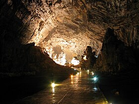
A show cave—also called tourist cave, public cave, and, in the United States, commercial cave—is a cave which has been made accessible to the public for guided visits.

Rioverde is a city and its surrounding municipality located in the south-central part of the state of San Luis Potosí, Mexico. It is the fifth-most populated city in the state, behind San Luis Potosí, Soledad de Graciano Sánchez, Ciudad Valles, and Matehuala. It is the agricultural, economic, turistic and demographic most important core in the Zona Media, one of the four geographical divisions of the state. The city had a 2005 census population of 49,183, while the municipality, of which it serves as municipal seat, had a population of 85,945 and an area extent of 3,109.71 km². The population of its metropolitan area, which includes the largest municipality of Ciudad Fernández, was 126,997.

Majestic Caverns is a series of caves and a tourist attraction located in Childersburg, Talladega County, Alabama. Located in the foothills of the Appalachian Mountains, it is touted as "Alabama's Big Cave". In addition to the caves, the park offers various other attractions, including a three-quarter acre maze known as the Lost Trail Maze, panning for gemstones, a climbing wall, and amusement park style rides. While on the caverns tour, visitors can view a sound, light, and water show that changes with the holidays and seasons.
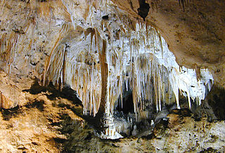
<span class="mw-page-title-main">Carlsbad Caverns National Park</span> National Park in New Mexico, United States

Carlsbad Caverns National Park is an American national park in the Guadalupe Mountains of southeastern New Mexico. The primary attraction of the park is the show cave Carlsbad Cavern. Visitors to the cave can hike in on their own via the natural entrance or take an elevator from the visitor center.
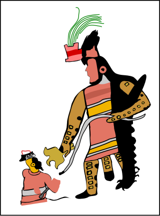
<span class="mw-page-title-main">Juxtlahuaca</span>

JuxtlahuacaSpanish pronunciation: [xuʃtɬaˈwaka] is a cave and archaeological site in the Mexican state of Guerrero containing murals linked to the Olmec motifs and iconography. Along with the nearby Oxtotitlán cave, Juxtlahuaca walls contain the earliest sophisticated painted art known in Mesoamerica, and only known example of non-Maya deep cave art in Mesoamerica.

<span class="mw-page-title-main">Ixtapan de la Sal</span> Town & Municipality in State of Mexico, Mexico

Ixtapan de la Sal is a town and municipality located in the State of Mexico, Mexico. It is 60 km south of Toluca, the state's capital, and 120 km south of Mexico City by the Federal Road 55. The word Ixtapan comes from Nahuatl. There are two theories as to the origin of the name. The first one states that it is composed of iztal, which means 'salt', and pan, which means 'over' or 'in'. The second one states that it comes from iztac which means 'white'; atl which means 'water'; and pan which means 'in white waters'. The phrase de la Sal is Spanish for 'of salt'.

Federal Highway 166 is a Federal Highway of Mexico. The highway travels from north of Axixintla, Guerrero near Grutas de Cacahuamilpa National Park in the west to Alpuyeca, Morelos in the east.

<span class="mw-page-title-main">Taxco de Alarcón (municipality)</span> Municipality in Guerrero, Mexico

Taxco de Alarcón is one of the 81 municipalities of Guerrero, in south-western Mexico. The municipal seat lies at Taxco de Alarcón. The municipality covers an area of 347 km².

The Lake Shasta Caverns are a network of caves located near the McCloud arm of Shasta Lake in California. It was formerly named Chalk Cave and Baird Cave, named after Spencer Fullerton Baird.

<span class="mw-page-title-main">Parque Nacional de las Cavernas del Río Camuy</span> Cave system in Camuy, Puerto Rico

The Parque Nacional de las Cavernas del Río Camuy is a cave system in Puerto Rico. It is located between the municipalities of Camuy, Hatillo, and Lares in northwestern Puerto Rico, but the main entrance to the park is located in Quebrada, Camuy. The caverns are part of a large network of natural limestone caves and underground waterways carved out by the third-largest underground river in the world, the Río Camuy. The cave system was "discovered" in 1958 and was first documented in the 1973 book Discovery at the Río Camuy (ISBN 0-517-50594-0) by Russell and Jeanne Gurnee, but there is archaeological evidence that these caves were explored hundreds of years ago by the Taíno Indians, Puerto Rico's first inhabitants. Over 10 miles of caverns, 220 caves and 17 entrances to the Camuy cave system have been mapped so far. This, however, is only a fraction of the entire system which many experts believe still holds another 800 caves. Only a small part of the complex is open to the public. The 268-acre park built around the cave system features tours of some of the caves and sinkholes, and is one of the most popular natural attractions in Puerto Rico. After restorations necessitated by Hurricane Maria, a destructive storm that struck Puerto Rico in 2017, the park re-opened on March 24, 2021.

<span class="mw-page-title-main">Grutas de García</span> Cave in Mexico

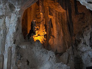
Grutas de García is a cave complex located 9 km outside García, Nuevo León in northern Mexico about 30 km from Monterrey. The caves are inside Sierra del Fraile mountain and protected area. The easiest way to reach the entrance to the caves is by taking a five-minute ride on the aerial tramway, but there is a steep path that can be taken to reach the caves.

<span class="mw-page-title-main">Gruta das Torres</span>

Gruta das Torres, is a lava cave, a geological formation of volcanic origin formed from the flow and cooling of subterranean magma rivers. This formation is located outside the parish of Criação Velha, in the municipality of Madalena, on the western flanks of the island of Pico. The cave system formed from a series of pāhoehoe lava flows which originating from the Cabeço Bravo parasitic cone about 500 to 1500 years ago. The caves are a group of interconnected lava tubes between 0.5–22 metres (2–72 ft) width, created from both pāhoehoe and ʻaʻā types of lavas generated during different geological periods. It has a height between 1.1 and 15 metres (3.6–49 ft) and is located at an elevation of 300 metres (980 ft). With an estimated length of over 5.2 km (3.2 mi) it is the longest lava cave in the Azores. Access to the cave was managed by the Mountaineering Association. Starting in 2011, AZORINA, SA took over the management and organization of the cave.

<span class="mw-page-title-main">Triangle of the Sun</span> Place in Guerrero, Mexico

The Triangle of the Sun is a tourist area in the state of Guerrero that runs through the Sierra Madre del Sur of that state. This tourist area is formed by the cities of Acapulco in the south, the pair of Ixtapa-Zihuatanejo in the north, and Taxco in the center of the state. These cities are those that receive more tourists in Guerrero.

<span class="mw-page-title-main">Baradla cave</span> Cave system in Hungary and Slovakia

The Baradla Domica cave system in Hungary is one of the longest researched, visited for centuries for its speleothems. As part of the Aggtelek Karst, the cave system extends more than 25.5 km (25,500 m) and includes the 5.3 km (3.3 mi) Domica cave. The cave has a natural entrance at Aggtelek, at the foot of a high white cliff that overlooks the edge of the village. It has an articulated, meandering main channel 7 km (4.3 mi) long, with a rock tunnel, on average, 10 m (33 ft) wide and 7 to 8 m high with a few giant caverns. The main branch has several short and long connecting side branches. A significant part of the cave has varied colors and shapes providing an unparalleled spectacle of decorative stalactites. Subterranean river waters run through the main branch at times of flood. Natural entrances to the cave have been open from ancient times, and there are traces of Neolithic occupation.

<span class="mw-page-title-main">Grutas de Cacahuamilpa (painting by Baron Gros)</span>

Cacahuamilpa's Grottos is an oil painting finished in 1835 by Jean-Baptiste Louis Gros, after his second visit to the caves in Grutas de Cacahuamilpa National Park, in Guerrero, Mexico. It is now in the Museo Soumaya, Mexico City.

Nombre de Dios Grottoes is a cave system in the state of Chihuahua, Mexico. The main entrance of the cavern is located in the middle of the Cerro del Caballo of the Sierra de Nombre de Dios, approximately 200 m (660 ft)) from the Sacramento River, northeast of the state capital Chihuahua City. This elaborate cave system came to official attention during the sixteenth century. The location might have previously been used for ceremonial purposes by Apache, Comanche and others of the many local indigenous people.

References

  1. http://www.conanp.gob.mx/sig/decretos/parques/Cacahuamilpa.pdf [ bare URL PDF ]
  2. 1 2 3 4 5 6 7 8 9 10 11 12 13 "Grutas de Cacahuamilpa-Sito Oficial" (in Spanish). Archived from the original on 27 February 2009. Retrieved 23 July 2009.
  3. 1 2 3 4 5 6 Quintanar Hinajosa, Beatriz (2009). "Rutas Turisticas: Guerrero: El destino del mundo". Mexico Desconocido (in Spanish). Mexico City: Grupo Editorial Impresiones Aereas. 135: 94–95. ISSN   0188-5146.
  4. 1 2 3 4 5 6 7 8 9 10 11 12 13 14 "Grutas de Cacahuamilpa Guerrero". Maravillas Naturales de Mexico (in Spanish). Mexico City: Mina Editories (22): 46–48. March 2009. 04-1992-00000000681-101.
  5. "Grutas de Cacahuamilpa (Guerrero)" (in Spanish). Mexico City: Mexico Desconocido. Retrieved 23 July 2009.
  6. 1 2 3 4 5 6 7 8 9 10 "Grutas de Cacahuamilpa Cacahuamilpa caves" . Retrieved 23 July 2009.
  7. Santiaguez Zavala, Francisca (2006-01-26). "Cacahuamilpa, turismo desaprovechado" (in Spanish). Mexico City: Terra. Retrieved 23 July 2009.
  8. 1 2 ") RITA turismo indigena Union de pobladores de Comunidades Posesionarias del Parque Nacional Grutas de Cacahuamilpa Guerrero" (in Spanish). Archived from the original on June 21, 2009. Retrieved 23 July 2009.
  9. "Ofrece Miguel Bosé concierto en las Grutas de Cacahuamilpa" (in Spanish). Mexico City: El Universal. Notimex. 2007-10-10. Retrieved 23 July 2009.
  10. "Concierto Especial Jornadas Alarconianas Grutas de Cacahuamilpa" (in Spanish). Archived from the original on 19 March 2014. Retrieved 23 July 2009.
  11. "Las Grutas de Cacahuamilpa" . Retrieved 23 July 2009.
  12. "Cacahuamilpa-Chontacoatlan-Taxco, Guerrero" . Retrieved 23 July 2009.
  13. "Tarzan and the Valley of Gold (1966)". Internet Movie Database. Retrieved 15 May 2017.