
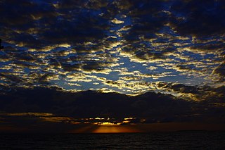
The Gulf of California, also known as the Sea of Cortés or Sea of Cortez, or less commonly as the Vermilion Sea, is a marginal sea of the Pacific Ocean that separates the Baja California peninsula from the Mexican mainland. It is bordered by the states of Baja California, Baja California Sur, Sonora, and Sinaloa with a coastline of approximately 4,000 km (2,500 mi). Rivers that flow into the Gulf of California include the Colorado, Fuerte, Mayo, Sinaloa, Sonora, and the Yaqui. The surface of the gulf is about 160,000 km2 (62,000 sq mi). Maximum depths exceed 3,000 meters (9,800 ft) because of the complex geology, linked to plate tectonics.
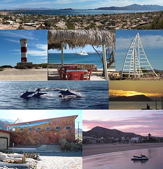
Bahía de los Ángeles is a coastal bay on the Gulf of California, located along the eastern shore of the Baja California Peninsula in the state of Baja California, Mexico. The town of the same name is located at the east end of Federal Highway 12 about 42 miles (68 km) from the Parador Punta Prieta junction on Federal Highway 1. The area is part of the San Quintín Municipality.

The Gulf Islands is a group of islands in the Salish Sea between Vancouver Island and the mainland coast of British Columbia.

The Revillagigedo Islands or Revillagigedo Archipelago are a group of four volcanic islands in the Pacific Ocean, known for their unique ecosystem. They lie approximately 458 kilometres (285 mi) from Socorro Island south and southwest of Cabo San Lucas, the southern tip of the Baja California Peninsula, and 698 to 1,092 kilometres west of Manzanillo. Historically linked to the Mexican state of Colima, to which they were granted in 1861 to establish a penal colony, the islands are under Mexican federal property and jurisdiction.

The Federal Dependencies of Venezuela encompass most of Venezuela's offshore islands in the Caribbean Sea and the Gulf of Venezuela, excluding those islands that form the State of Nueva Esparta and some Caribbean coastal islands that are integrated with nearby states. These islands, with a total area of 342 square kilometres, are sparsely populated – according to the preliminary results of the 2011 Census only 2,155 people live there permanently, with another hundred from Margarita Island who live there seasonally to engage in fishing. Local government is officially under the authority of Central government in Caracas, although de facto power is often held by the heads of the sparse and somewhat isolated communities that decorate the territories.
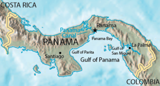
The Gulf of Panama is a gulf of the Pacific Ocean off the southern coast of Panama, where most of eastern Panama's southern shores adjoin it. The Gulf has a maximum width of 250 kilometres, a maximum depth of 220 metres (722 ft) and the size of 2,400 square kilometres (930 sq mi). The Panama Canal connects the Gulf of Panama with the Caribbean Sea, thus linking the Pacific and Atlantic oceans. The Panamanian capital Panama City is the main urban centre on the gulf shore.

The Golden Gate Biosphere Network is a voluntary coalition of federal, state and local government agencies, nonprofit organizations, universities, and private partners within the Golden Gate Biosphere region. The Network aims to protect the region's biodiversity and conserve its natural resources. The Network has been part of the UNESCO Man and Biosphere Programme since 1988.GGBN is also part of the US Biosphere Network as well as EuroMAB. It is recognized by UNESCO for its "significance for biological diversity conversation" and organizational efforts involving municipal authorities and private interests.

The Cíes Islands are an archipelago off the coast of Pontevedra in Galicia, Spain, in the mouth of the Ria de Vigo. They were declared a Nature Reserve in 1980 and are included in the Atlantic Islands of Galicia National Park created in 2002.

The Los Roques Archipelago is a federal dependency of Venezuela consisting of approximately 350 islands, cays, and islets in a total area of 40.61 km2 (15.68 sq mi). The archipelago is located 128 km (80 mi) directly north of the port of La Guaira, in the Caribbean Sea.

Isla Espíritu Santo is an uninhabited island in the Gulf of California, off the Mexican state of Baja California Sur. It is separated from Isla Partida by a narrow canal.
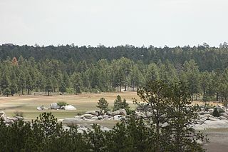
Constitution 1857 National Park is located in the pine forests of the Sierra de Juárez mountain range in the northern part of Baja California, Mexico. The park is an important preserve for many native wild animals like bighorn sheep and mule deer. The park is characterized by the large variety of coniferous plant species.
The Old Providence McBean Lagoon National Natural Park is a national park located on the northeast side of Providencia Island in the Archipelago of San Andrés, Providencia and Santa Catalina, Colombia.
The Rosario and San Bernardo Corals National Natural Park is a natural park located in the Sucre and Bolívar Departments on the coast of the Caribbean Region of Colombia, 45 km from the Bay of Cartagena. It was the most visited national park in Colombia in 2009, with 318,473 visitors.

The Cabrera Archipelago Maritime-Terrestrial National Park is a national park that includes the whole of the Cabrera Archipelago in the Balearic Islands, an autonomous community that is part of Spain. The park is the largest in Spain, covering 908 square kilometres (351 sq mi) including 895 square kilometres (346 sq mi) of sea area. The park attracts relatively few visitors due to its remoteness. There is no permanent population, but there might be at any given time just under 100 National Park staff members and other personnel on the islands.
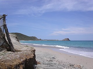
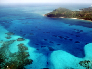
Cabo Pulmo National Park is a national marine park on the east coast of Mexico's Baja California Peninsula, spanning the distance between Pulmo Point and Los Frailes Cape, approximately 100 kilometres (62 mi) north of Cabo San Lucas in the Gulf of California. Bahía Pulmo is home to the oldest of only three coral reefs on the west coast of North America. Cabo Pulmo is estimated to be 20,000 years old. The 27 square mile national park is home to 11 different species of coral. It is the northernmost coral reef in the eastern Pacific Ocean.
The Protected Areas of the Azores are the basic administrative-territorial and conservation structures in the archipelago of the Azores and the surrounding oceans. The areas integrate the entirety of the Azores within its Exclusive Economic Zone, as well as the surrounding waters, under the international agreements and conventions. The network realizes the categorization of management for protected areas adopted by the International Union for Conservation of Nature (IUCN), adapting it to the specific geographical, environmental, cultural and political-administrative territory of the archipelago.

The Ilhas dos Currais Marine National Park is a national park in the state of Paraná, Brazil. It protects an important nesting site for birds, and is a refuge and feeding ground for fish including two endangered species of grouper. It may be visited for diving, but visitors must be careful to avoid any impact on the environment.

Exequiel Ezcurra is an Argentine-Mexican plant ecologist and conservationist. His highly interdisciplinary work spans desert plant ecology, mangroves, island biogeography, sea birds, fisheries, oceanography, and deep-sea ecosystems.

Bahía de Loreto National Park is a national park on the east coast of the Baja California Peninsula in Mexico, about 203 kilometres (126 mi) north of the city of La Paz in the state of Baja California Sur. The park protects 2,065.81 square kilometres (797.61 sq mi) of relatively pristine marine ecosystem in the central Sea of Cortez, including five large uninhabited islands and many smaller islets in Loreto Bay. It is known for its great variety of coastal environments, such as sandy beaches, sea cliffs, submarine canyons, and marine terraces, and is home to an exceptionally high biological diversity, especially of marine mammals.
El Potosí National Park is a protected area in northwestern Mexico. It is located in San Luis Potosí.It has an area of 20 km2.


