
Morelos, officially the Free and Sovereign State of Morelos, is a landlocked state located in south-central Mexico. It is one of the 32 states which comprise the Federal Entities of Mexico. It is divided into 36 municipalities and its capital city is Cuernavaca.
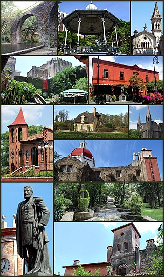
Cuernavaca is the capital and largest city of the state of Morelos in Mexico. Along with Chalcaltzingo, it is likely one of the origins of the Mesoamerican civilization. Olmec works of art, currently displayed in the Museum of Anthropology in Mexico City were found in the Gualupita III archeological site.

Cuautitlán Izcalli is a city and one of the 125 municipalities that make up the State of Mexico. Its municipal seat is Cuautitlán Izcalli. It is located in the Valley of Mexico area, and is part of the Metropolitan area of Mexico City. It borders to the north and northwest with Tepotzotlán, to the northeast and to the east with Cuautitlán, to the south with Tlalnepantla de Baz, to the southeast with Tultitlán, to the southwest with Atizapán de Zaragoza and to the west with the municipality of Nicolás Romero.
Huitzilac is a city in the Mexican state of Morelos. It stands at 19°01′42″N 99°16′02″W and at an altitude of 2,561 m (8,402 ft) above sea level.

Jiutepec is a city and its surrounding municipality in the Mexican state of Morelos.

Puente de Ixtla is a city in the Mexican state of Morelos. It stands at 18°37′01″N99°19′23″W. The city serves as the municipal seat for the surrounding municipality of the same name. The municipality reported 66,435 inhabitants in the year 2015 census.

Temixco is the fourth-largest city in the Mexican state of Morelos. It stands at 18°51′N99°14′W in the west-northwest part of the state.

Yautepec is a municipality located in the north-central part of the Mexican state of Morelos. The municipal seat is the city of Yautepec de Zaragoza. It stands at 18°53′N99°04′W.

Zacatepec de Hidalgo is a town in the state of Morelos, Mexico. It is bordered by Puente de Ixtla, Tlaltizapán, Tlaquiltenango and Jojutla. Miguel Hidalgo was the priest whose call to arms on September 16, 1810, led to the Mexican War of Independence.

Iztaccíhuatl–Popocatépetl National Park, also known as Izta-Popo Zoquiapan National Park, is a national park in Mexico on the border of the states of México, Puebla, and Morelos. The park protects 39,819.08 hectares, surrounding Mexico's second- and third-highest peaks, the Popocatépetl and Iztaccíhuatl volcanoes as well as the area of the Hacienda de Zoquiapán, and its annexed areas (anexas) of Zoquiapan, Ixtlahuacán, and the Frío de Juárez River.
Oaxtepec is a town within the municipality of Yautepec and the Cuautla metropolitan area in the eastern part of the Mexican state of Morelos. Its main industry is tourism, mostly aimed at the inhabitants of nearby Mexico City, and the town possesses various aquatic resorts and hotels. The climate is tropical and the countryside very lush.
Federal Highway 95 connects Mexico City to Acapulco, Guerrero. The Autopista del Sol is a tolled alternative, which bypasses several towns of the state of Guerrero, including the city Iguala, and thus reduces transit time between Acapulco from Mexico city from 8 hours to almost 3.5 hours.

San Lorenzo Marine Archipelago National Park is a national park of Mexico located on San Lorenzo Island part of an archipelago in the Gulf of California off the eastern coast of Baja California. The San Lorenzo Archipelago is considered one of the most important ecological areas of the Gulf of California. The Island and surrounding areas are part of a rich ecosystem comprised by a grand variety of flora and marine fauna. This area is protected by the Mexican federal government Norma Oficial Mexicana NOM-059-SEMARNAT-2001 because of its importance as a habitat for several endangered species. The Archipelago is part of the municipality of Mexicali, Baja California. The island is located southeast of the city separated by the Salsipuedes Channel.
Constitution 1857 National Park is located in the pine forests of the Sierra de Juárez mountain range in the northern part of Baja California, Mexico. The park is an important preserve for many native wild animals like bighorn sheep and mule deer. The park is characterized by the large variety of coniferous plant species.

Lagunas de Montebello, or Montebello Lakes, is a national park in the Mexican state of Chiapas, near the border with Guatemala, comprising 59 multi-colored lakes in a pine forest and two Maya ruins. It was the first national park in Chiapas when created in 1959, and in 2009 the park was designated a Biosphere Reserve by UNESCO.
Acapantzingo is a barrio in the southeastern part of the City of Cuernavaca, Morelos, Mexico, 2 km from the city center. The Nahuatl name means on the slope of the reeds. It is bound by the Río Chalchihuapan on the west, Colonia Atlacumulco, Jiutepec to the east and south, Colonia Palmira to the south, and Calle Cuauhatemoc to the north.

The Sierra del Ajusco-Chichinauhtzin, also known as Serranía del Ajusco or Sierra de Chichinauhtzin, is a Mexican mountain range located between Mexico City and the states of Morelos and Mexico. It makes up the southern part of the mountain necklace that surrounds Mexico City. It is made up of more than one hundred volcanic cones, among which are: Tláloc, Chichinauhtzin (3,430 metres, Xitle (3,100 metres, Cerro Pelado (3,600 metres and Cuauhtzin (3,510 metres. Its maximum height is at the Cruz del Marqués peak on the Ajusco volcano.
The Chichinautzin Biological Corridor is a protected natural area in central Mexico. It is located south of Mexico City in the Sierra de Ajusco-Chichinauhtzin, an east–west chain of volcanic mountains which are part of the Trans-Mexican Volcanic Belt.
The Cuernavaca Municipality is one of 36 municipalities in the State of Morelos, Mexico. Located in the northwest of the state, it consists of the City of Cuernavaca, which is the state and municipal capital, as well as other, smaller towns. The population is 378,476 (2020).

El Tepozteco National Park is a national park in Morelos state of central Mexico. It protects 232.58 km2 in the mountains of the Trans-Mexican Volcanic Belt. The park includes El Tepozteco, an archeological site featuring an Aztec temple.


