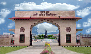
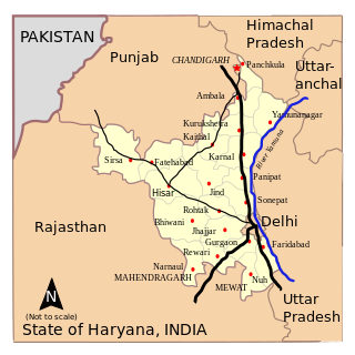
Haryana is an Indian state located in the northern part of the country. It was carved out after the linguistic reorganisation of Punjab on 1 November 1966. It is ranked 21st in terms of area, with less than 1.4% of India's land area. The state capital is Chandigarh, which it shares with the neighbouring state of Punjab; the most populous city is Faridabad, a part of the National Capital Region. The city of Gurgaon is among India's largest financial and technology hubs. Haryana has 6 administrative divisions, 22 districts, 72 sub-divisions, 93 revenue tehsils, 50 sub-tehsils, 140 community development blocks, 154 cities and towns, 7,356 villages, and 6,222 villages panchayats.
Languages of India belong to several language families, the major ones being the Indo-Aryan languages spoken by 78.05% of Indians and the Dravidian languages spoken by 19.64% of Indians; both families together are sometimes known as Indic languages. Languages spoken by the remaining 2.31% of the population belong to the Austroasiatic, Sino–Tibetan, Tai–Kadai, and a few other minor language families and isolates. According to the People's Linguistic Survey of India, India has the second highest number of languages (780), after Papua New Guinea (840). Ethnologue lists a lower number of 456.

Noida, short for New Okhla Industrial Development Authority, is a city located in Gautam Buddha Nagar district of the Indian state of Uttar Pradesh. Noida is a satellite city of Delhi and is a part of the National Capital Region. As per provisional reports of Census of India, the population of Noida in 2011 was 642,381. The city is managed by New Okhla Industrial Development Authority (NOIDA). The district's administrative headquarters are in the nearby city of Greater Noida.

Ulhasnagar is a city located 26 km from Thane City in Thane district, Maharashtra, India. This city is a part of Mumbai Metropolitan Region managed by the MMRDA. It had an estimated population of 506,098 at the 2011 Census. Ulhasnagar is a municipal city and the headquarters of the Tahsil bearing the same name. It has a suburban station on the Central line of the Mumbai Suburban Railway.

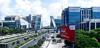
Faridabad is the most populous city near NCT of Delhi in the Indian state of Haryana and a part of Delhi National Capital Region. It is one of the major satellite cities around Delhi and is located 284 kilometres south of the state capital, Chandigarh. The river Yamuna forms the eastern district boundary with Uttar Pradesh. The Government of India included it in the second list of Smart Cities Mission on 24 May 2016. As per the 2021 Delhi Regional Plan, Faridabad is a part of the Central National Capital Region or Delhi metropolitan area.
Mohali, officially Sahibzada Ajit Singh Nagar, is a planned city in the Mohali district in Punjab, India, which is an administrative and a commercial hub lying south-west of Chandigarh. It is the headquarters of the Mohali district and one of the six Municipal Corporations of the State. It is officially named after Sahibzada Ajit Singh, the eldest son of Guru Gobind Singh.

Yamunanagar, is a city and a municipal corporation in Yamunanagar district in the Indian state of Haryana. This town is known for the cluster of plywood units and paper factories. It provides timber to larger industries. The older town is called Jagadhri. The Yamunanagar-Jagadhri railway station (YJUD) services the city. Despite its name, Jagadhri Railway is situated in Yamunanagar. There is also another railway station called Jagadhri Workshop in Yamunanagar.
Faridabad district is one of the 22 districts of the Indian state of Haryana with Faridabad city being the district headquarters. The District is a Part of Central National Capital Region of Delhi. The Delhi-Mathura-Agra National Highway 44 passes through the centre of the district, which occupies an area of 741 square kilometres (286 sq mi) and as of the 2011 census of India had a population of 1,809,733. Haryana government has created a new Faridabad division which would cover the districts – Faridabad, Nuh and Palwal.

Panchkula is a city and district headquarter in the Panchkula district in Haryana, India. It is a satellite town of the state capital Chandigarh. Panchkula is a border city with Punjab, Chandigarh and Himachal Pradesh. The origin of the name Panchkula came from "the place where five irrigation canals meet". It is approximately 4 km (2.5 mi) southeast of Chandigarh, 105 km (65 mi) southwest of Shimla, 44 km (27 mi) from Ambala and 259 km (161 mi) northeast of New Delhi, the national capital. It is a part of the Chandigarh capital region or Greater Chandigarh. The Chandigarh-Mohali-Panchkula metropolitan region collectively forms a Chandigarh Tricity, with a combined population of over two million.
Rohtak is a city and the administrative headquarters of the Rohtak district in the Indian state of Haryana. It lies 70 kilometres (43 mi) north-west of New Delhi and 250 kilometres (160 mi) south of the state capital Chandigarh on NH 9. Rohtak forms a part of the National Capital Region (NCR) which helps the city in obtaining cheap loans for infrastructure development from the NCR Planning Board.

Ambala district is one of the 22 districts of Haryana state in the country of India with Ambala town serving as the administrative headquarters of the district. District Ambala lies on the North-Eastern edge of Haryana and borders Punjab and Himachal Pradesh. Ambala district is a part of Ambala Division.

Thoubal district is one of the sixteen districts of Manipur state in northeastern India. This district is bounded by Imphal East on the north, Kangpokpi District and Tengnoupal District districts on the east, Kakching district on the south and Imphal West district on the west. The district occupies an area of 324 km2. The population as of 2011 is 286,687. Thoubal town is the district headquarters. This district is known for Khongjom, where the last battle of the independence of Manipur was fought in April 1891 against the British army.

Greater Noida is a planned city located in the Gautam Buddha Nagar district of the Indian state of Uttar Pradesh. Established in 1991 under the UP Industrial Area Development Act of 1976, it is part of the National Capital Region (NCR) and serves as an extension to the city of Noida. Situated 40.2 km southeast of New Delhi, Greater Noida is connected to the capital via the Noida-Greater Noida Expressway, which takes approximately 30 minutes to travel.The city is administered by the Greater Noida Industrial Development Authority (GNIDA) and covers an area of 38,000 hectares. Originally conceived to alleviate Delhi's rapid expansion and demographic pressure, Greater Noida has evolved into a significant hub for education, industry, and sports. The city is known for its wide roads, planned sectors named after Greek letters, and underground utilities.As per the 2011 census, Greater Noida had a population of 107,676, with a literacy rate of 86.54%. The city has attracted major investments in various sectors, including education, with several universities and institutes establishing campuses in the area. Greater Noida has also gained prominence in sports, hosting international events such as the Formula One Indian Grand Prix at the Buddh International Circuit.
Manwath is a city with municipal council in Parbhani district in the Indian state of Maharashtra.

Radaur is a town and municipal committee in Yamunanagar district in the Indian state of Haryana. It approx. 17 km from Yamunanagar, the district headquarters.

The Ministry of Minority Affairs is the ministry in the Government of India which was carved out of the Ministry of Social Justice and Empowerment and created on 29 January 2006. It is the apex body for the central government's regulatory and developmental programmes for the minority religious communities and minority linguistic communities in India, which include Muslims, Sikhs, Christians, Buddhists, Zoroastrians (Parsis) and Jains notified as minority religious communities in The Gazette of India under Section 2(c) of the National Commission for Minorities Act, 1992.
Namkum is a community development block forming an administrative division in the Ranchi Sadar subdivision of Ranchi district in the state of Jharkhand.
Elections in Haryana, which is a state in India, have been conducted since 1967 to elect the members of state-level Haryana Legislative Assembly and national-level Lok Sabha. There are 90 assembly constituencies and 10 Lok Sabha constituencies.
Tandwa is a community development block that forms an administrative division in the Simaria subdivision of the Chatra district, Jharkhand state, India.
Mohanpur is a community development block that forms an administrative division in the Deoghar subdivision of the Deoghar district, Jharkhand state, India.

