Neidlingen

Last updated • 5 min readFrom Wikipedia, The Free Encyclopedia
Neidlingen
NeidlingenWasserfall.jpg
The Lindach near Neidlingen
DEU Neidlingen COA.svg
Location of Neidlingen within Esslingen district
Neidlingen in ES.svgAltdorfBeurenDenkendorfHochdorfKohlbergKohlbergOwen
Germany adm location map.svg
Red pog.svg
Neidlingen
Baden-Wuerttemberg location map.svg
Red pog.svg
Neidlingen
Coordinates: 48°34′45″N9°33′54″E / 48.57917°N 9.56500°E / 48.57917; 9.56500
Country Germany
State Baden-Württemberg
Admin. region Stuttgart
District Esslingen
Government
   Mayor (202129) Jürgen Ebler [1]
Area
  Total12.62 km2 (4.87 sq mi)
Elevation
456 m (1,496 ft)
Population
 (2021-12-31) [2]
  Total1,799
  Density140/km2 (370/sq mi)
Time zone UTC+01:00 (CET)
  Summer (DST) UTC+02:00 (CEST)
Postal codes
73272
Dialling codes 07023
Vehicle registration ES
Website www.neidlingen.de

Neidlingen (Swabian: Neidlenge) is a municipality in the district of Esslingen, in Baden-Württemberg, Germany.

Contents

History

In 1807, Neidlingen, formerly a possession of the Kingdom of Bavaria, was assigned to the district of Wiesensteig in the Kingdom of Württemberg. The town was reassigned in 1810 to Oberamt Kirchheim  [ de ]. [3]

Nazi Germany and World War II

The Nazi Party was a political non-entity in Neidlingen until the federal elections of 1930, but only secured local plurality in the 1932 state election. A local Nazi Party affiliate was formed that year under Wilhelm Aysslinger, the party district manager. In the March 1933 German federal election, the Nazis received 80.6% of the vote in Nedilingen, and that May three Nazis were elected to the six-member municipal council. Oberamt Kirchheim was dissolved in 1938 and Neidlingen was assigned to Landkreis Nürtingen. [3]

29 forced laborers from Poland, Russia, and Ukraine arrived at Neidlingen in 1941 to work on local farms. The US Army occupied the town on 21 April 1945 after a short fight with units of the German Army and German-aligned Russian Liberation Army. [3]

After World War II

Neidlingen experienced a period of industrial growth in the 1950s. In 1973, following that year's reform of the districts  [ de ] of Baden-Württemberg, the town was assigned to the district of Esslingen. [3]

Geography

The municipality ( Gemeinde ) of Neidlingen covers 12.60 square kilometers (4.86 sq mi) of the Esslingen district of Baden-Württemberg, a state of the Federal Republic of Germany. It is located 26 kilometers (16 mi) from the district capital, Esslingen am Neckar, on the district's south-east tip and along the border with the district of Göppingen. Inside Esslingen's district, Neidlingen shares a border with Weilheim an der Teck, Bissingen an der Teck and Lenningen. The municipality is physically located along the northern edge of the central foothills  [ de ] of the Swabian Jura, and stretches form the heights of the upper valley of the Lindach to the albtrauf of the Fils. 46% of the municipal area is covered in forest. Another 45% is used for agriculture, primarily for orchards. Its boundaries generally decided by the lay of the albtrauf, which sits atop the Brown and White Jurassic formations. [3]

Neidlingen itself is sits upon the confluence of the Lindach and the Seebach, above the Eisensandstein Formation  [ de ]. The Lindach and its valley begins to the southwest of the town in a plateau of the Jura that averages an elevation above sea level of 760 meters (2,490 ft) Normalnull (NN). The highest elevation in the municipality, 800 meters (2,600 ft) NN, is found here in the Drittelwald. The Lindach valley continues through Neidlingen to the northwest, widening until being narrowed by the Erkenberg and the Burz. Upon these limestone bluffs are juniper groves and sheep pastures that have been placed under Federal protection as the Unter dem Burz  [ de ] and Erkenbergwasen  [ de ] nature reserves. Beyond this, the Lindach continues and marks the lowest elevation above sea level in the municipal area, 423 meters (1,388 ft) NN. The slopes of the valley are formed by the Opalinuston Formation  [ de ]. Near the Erkenberg and the Burz are springs that turn the edges of the Linbach's basin into marshland that have been named a protected body of water  [ de ] and was connected to the Baden-Württemberg State Water Supply  [ de ] in 2002. [3]

Neidlingen is east of the Randecker Maar (a former volcanic vent) and is part of the Swabian Alps Biosphere Reserve  [ de ]. [4]

Demographics

Population development: [5]

YearInhabitants
19901.722
20011.916
20111.800
20211.799

Politics

Neidlingen has one borough (Ortsteil), Neidlingen. There are five abandoned villages in its municipal area: Heimenstein, Lichtenstein, Merkenberg, Reußenstein, and Windeck. [3]

Klaus Däschler has been mayor of Neidlingen since 2014. [6] In 2021 Jürgen Ebler was elected mayor. [1]

Coat of arms

Neidlingen's municipal coat of arms has its field divided party per fess into an upper, white section containing a green oak branch and a lower, green section with a large, white "N". This pattern dates to 1669, though the "N" first appeared in an earlier coat of arms from 1616. The oak branch was, from 1930 to 1953, replaced with a tree flanked by two saplings. The tincture was decided in 1953, and on 15 June 1953, the coat of arms was approved for official use by the provisional Württemberg-Baden government. The Federal Ministry of the Interior reapproved the coat of arms on 16 August 1973. [3]

Transportation

The L1200 runs through the center of Neidlingen. [3]

Citations

  1. 1 2 Bürgermeisterwahl Neidlingen 2021, Staatsanzeiger, accessed 29 August 2022.
  2. "Bevölkerung nach Nationalität und Geschlecht am 31. Dezember 2021" [Population by nationality and sex as of December 31, 2021](CSV) (in German). Statistisches Landesamt Baden-Württemberg. June 2022.
  3. 1 2 3 4 5 6 7 8 9 "Neidlingen". LEO-BW (in German). Baden-Württemberg . Retrieved 14 July 2020.
  4. Kohlhammer 1978, pp. 251–52.
  5. "Neidlingen (Esslingen, Baden-Württemberg, Deutschland) - Einwohnerzahlen, Grafiken, Karte, Lage, Wetter und Web-Informationen". citypopulation.de. Retrieved 2023-07-27.
  6. Stolte, Ulrich (1 December 2013). "Kommissar stürzt Bürgermeister". Stuttgarter Zeitung (in German). Retrieved 15 July 2020.

Related Research Articles

Esslingen is a Landkreis (district) in the centre of Baden-Württemberg, Germany. Neighboring districts are Rems-Murr, Göppingen, Reutlingen, Böblingen and the district-free city Stuttgart.

<span class="mw-page-title-main">Bitz</span> German municipality

Bitz is a municipality in the Zollernalbkreis district of Baden-Württemberg, Germany.

<span class="mw-page-title-main">Kirchheim unter Teck</span> Town in Baden-Württemberg, Germany

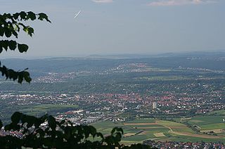
Kirchheim unter Teck is a town in Baden-Württemberg, Germany, in the district of Esslingen. It is located on the small river Lauter, a tributary of the Neckar. It is 10 km near the Teck castle, approximately 35 kilometres southeast of Stuttgart. It is the fourth city in the Esslingen district, forming a district centre for the surrounding communities.

<span class="mw-page-title-main">Ebersbach an der Fils</span> German city

Ebersbach is a town in the district of Göppingen in Baden-Württemberg, in southern Germany.

<span class="mw-page-title-main">Schömberg, Zollernalbkreis</span> German town

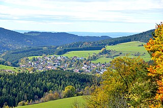
Schömberg is a town in the Zollernalbkreis district of Baden-Württemberg, Germany.

<span class="mw-page-title-main">Rangendingen</span> German municipality

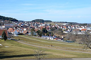
Rangendingen is a municipality of the Zollernalbkreis district, in Baden-Württemberg, Germany.

<span class="mw-page-title-main">Bissingen an der Teck</span> Municipality in Baden-Württemberg, Germany

Bissingen is a municipality in the district of Esslingen in Baden-Württemberg in southern Germany.

<span class="mw-page-title-main">Hochdorf, Esslingen</span> Municipality in Baden-Württemberg, Germany

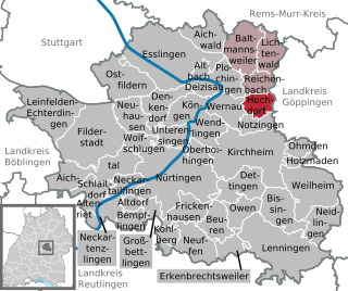
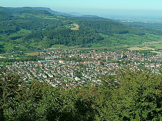
Hochdorf is a municipality in the district of Esslingen in Baden-Württemberg in southern Germany. Mayor: 1986 - 31.3.2009: Roland Erhardt, since 1.4.2009: Gerhart Kuttler

<span class="mw-page-title-main">Aichelberg</span> Municipality in Baden-Württemberg, Germany

Aichelberg is a municipality in the district of Göppingen in Baden-Württemberg in southern Germany.

<span class="mw-page-title-main">Deggingen</span> German municipality

Deggingen is a municipality in the district of Göppingen in Baden-Württemberg, Germany.

<span class="mw-page-title-main">Gingen an der Fils</span> German municipality

Gingen an der Fils is a municipality in the district of Göppingen in Baden-Württemberg, Germany.

<span class="mw-page-title-main">Salach</span> German municipality

Salach is a municipality in the district of Göppingen in Baden-Württemberg in southern Germany.

<span class="mw-page-title-main">Schlierbach (Göppingen)</span> German municipality

Schlierbach is a municipality in the district of Göppingen in Baden-Württemberg, Germany.

<span class="mw-page-title-main">Dautmergen</span> German municipality

Dautmergen is a municipality in the Zollernalbkreis district of Baden-Württemberg, Germany.

<span class="mw-page-title-main">Hausen am Tann</span> Town in Baden-Württemberg, Germany

Hausen am Tann is a town in the Zollernalbkreis district of Baden-Württemberg, Germany.

<span class="mw-page-title-main">Obernheim</span> German municipality

Obernheim is a municipality of the Zollernalbkreis district of Baden-Württemberg, Germany.

<span class="mw-page-title-main">Ratshausen</span> German municipality

Ratshausen is a municipality the Zollernalbkreis district, in Baden-Württemberg, Germany.

<span class="mw-page-title-main">Weilen unter den Rinnen</span> German municipality

Weilen unter den Rinnen (Weilen) is a municipality in the Zollernalbkreis district, in Baden-Württemberg, Germany.

<span class="mw-page-title-main">Zimmern unter der Burg</span> German municipality

Zimmern unter der Burg is a town in the Zollernalbkreis district, in Baden-Württemberg, Germany.

<span class="mw-page-title-main">Lauter (Neckar)</span> River in Germany

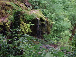
The Lauter is a right tributary of the Neckar in Baden-Württemberg, Germany. It arises on the Albtrauf escarpment of the Swabian Alb.

References