Plochingen

Last updated • 8 min readFrom Wikipedia, The Free Encyclopedia
Plochingen
HundertwasserPlochingen-pjt3.jpg
Hundertwasser house
Wappen Plochingen.svg
Location of Plochingen within Esslingen district
Plochingen in ES.svgAltdorfBeurenDenkendorfHochdorfKohlbergKohlbergOwen
Germany adm location map.svg
Red pog.svg
Plochingen
Baden-Wuerttemberg location map.svg
Red pog.svg
Plochingen
Coordinates: 48°42′42″N9°24′59″E / 48.71167°N 9.41639°E / 48.71167; 9.41639
Country Germany
State Baden-Württemberg
Admin. region Stuttgart
District Esslingen
Government
   Mayor (202432) Frank Buß [1]
Area
  Total10.65 km2 (4.11 sq mi)
Elevation
276 m (906 ft)
Population
 (2022-12-31) [2]
  Total14,611
  Density1,400/km2 (3,600/sq mi)
Time zone UTC+01:00 (CET)
  Summer (DST) UTC+02:00 (CEST)
Postal codes
73201–73207
Dialling codes 07153
Vehicle registration ES
Website www.plochingen.de

Plochingen (Swabian: Blocheng or Blochenga) is a town in the district of Esslingen in Baden-Württemberg in southern Germany. It lies on the river Neckar, on which it has a river port. With about 14,000 inhabitants, it is part of the Stuttgart Metropolitan Region.

Contents

Geography

Geographical location

Plochingen is about nine kilometres east-southeast of the district town Esslingen am Neckar and in the same direction about 19 kilometres from the state capital Stuttgart. The town is situated on the right banks of the Fils and the outflowing Neckar. In the area of the town, three Natural areas collide, the Foreland of the central Swabian Alb in the southeast, the subspace Schurwald of the natural area Schurwald and Welzheimer Wald in the northeast, and the subspace Nürtinger-Esslinger Neckartal, which is part of the Filder , along the larger of the two rivers in the west. The lowest point in the town area is in the very west at the outflow of the Neckar at 247 metres above sea level, the highest point is in the very north at the White Stone on the Schurwaldkamm at about 448 metres above sea level, from which forest areas cover a large part of the town area.

Neighboring villages/towns

Neighbouring towns are in turn the community Altbach in the west, the district town Esslingen am Neckar in the northwest, the community Baltmannsweiler in the northeast and the community Reichenbach an der Fils in the east, in the southeast briefly the municipality Hochdorf, in the south the town Wernau (Neckar), in the southwest the municipality Deizisau, all of which also belong to the district of Esslingen.

Urban planning

Plochingen includes the town of Plochingen and the district of Stumpenhof to the north-east of the town. [3]

Land usage

Plochingen

According to data from the Statistical State Office Baden-Württemberg, status 2014. [4]

History

Old town hall PlochingenRathaus2.jpg
Old town hall

Ancient

Due to its convenient location at the mouth of the Fils into the Neckar, people have been living in the area since the earliest times, which is attested by finds from the Stone Age. Finds of weapons and grave goods from the Bronze Age give evidence of a settlement belonging to the Urnfield culture. Also from the Hallstatt period grave mounds indicate that there might have been a continuous Celtic settlement up to the Roman period. In classical antiquity the Romans and in the early Middle Ages the Alamanni settled in the area. [5]

From the middle ages to the 19th century

In the High Middle Ages, Plochingen was situated in the territory of the Herzogtum Schwaben and formed part of the Neckargau. The place was first mentioned in 1146 as Blochingen in a document of the king Conrad III of Hohenstaufen. There were two castles in Plochingen, but nothing remains of them. [6] From the 12th to the 14th century the seat of a noble family can be proven for Plochingen. [7] In 1331, the lord of the castle Johann von Plochingen sold some property in Plochingen to the hospital in Esslingen. The Württemberg part of Plochingen, originally with the bailiwick of Nellingen, was already subordinated to the office in Stuttgart at the beginning of the 15th century. Since the 12th century Plochingen had had a market for building materials, salt and agricultural goods, including in particular wine, grain, fishing and livestock. [7] In 1536 Duke Ulrich von Württemberg pushed through the Reformation. [8] In 1545 the first bridge over the Neckar was built, replacing a medieval footbridge. In addition, a bridge over the Fils was built, so that bridge tolls could be charged for it. After the Battle of Nördlingen lost for Württemberg, Plochingen's convenient location had a negative effect on the traffic situation during the Thirty Years' War, as imperial troops plundered the town as early as 1634 and many houses burned down. The population of about 1300 people before the war sank to about 500 inhabitants after the war. In 1698 Plochingen became a post station on the imperial postal line between Antwerp and Venice, operated by the House of Thurn- und Taxis. In 1778 the Hofwerkmeister Johann Christian Adam Etzel (1743-1801; uncle of Gottlieb Christian Eberhard von Etzel) built the covered wooden bridge with a self-supporting span of 70 metres without intermediate pillars across the Neckar, which then became famous in Europe, [9] 1905 it was replaced by the extension of the railway station completely intact. In 1808, the municipality moved from the Amtsoberamt Stuttgart to the newly established Oberamt Esslingen in implementing the new administrative division of Württemberg in the Kingdom of Württemberg. In 1846, the construction of the Filstalbahn as far as Plochingen led to the connection to the emerging network of the Württembergische Staatsbahnen , only one year after a train had run for the first time in Württemberg on the line between Cannstatt and Untertürkheim . In 1888 the Schwäbische Albverein was founded in the Waldhorn Restaurant.

20th century

In 1905 the wooden bridge from 1778 was replaced by an iron bridge over the Neckar. On 1 June 1913 a tornado destroyed numerous buildings in Plochingen. [10] During the district reform during NS period in Württemberg Plochingen came to the district of Esslingen in 1938. After the Second World War, the community fell into the American occupation zone and was located in the state Württemberg-Baden from 1945 to 1952. On April 13, 1948, the municipality of Plochingen was elevated to the status of a town, which became part of the new federal state of Baden-Württemberg in 1952. On 12 July 1968 the Neckarhafen Plochingen was inaugurated. Since the beginning of the S-Bahn operation in the Stuttgart area on October 1, 1978, the vehicles have been technically maintained and cleaned in the Bahnbetriebswerk Plochingen.

In 1998, Plochingen hosted the Landesgartenschau Baden-Württemberg.

Religion

Since the Reformation Plochingen has been evangelical shaped. There is also a Roman Catholic church. In recent years, an Evangelical Methodist and a New Apostolic Church have also been established.

Population development

The population figures are estimates, or official updates of the Statistical Office.

DayPopulation
16181,320
1635250
1 December 18711,881
1 December 19002,413
17 May 19395,446
13 September 19508,148
6 July 196111,358
27 May 197012,953
25 May 198712,140
31 December 199513,085
31 December 200014,191
31 December 200514,319
31 December 201014,209
31 December 201513,997
31 December 201614,086
31 December 201714,213
31 December 201814,433

Politics

Administrative association

Plochingen forms with Altbach and Deizisau the Gemeindeverwaltungsverband Plochingen . Frank Buß, the mayor of the town of Plochingen, is the chairman of the administrative association. [11]

The town of Plochingen also runs its own businesses. These are the Stadtwerke (Public utilities), the Eigenbetrieb Abwasserbeseitigung (Own operation sewage disposal) and the Eigenbetrieb Wohnen (Owner-occupied living). [12]

Mayors

Town council

The municipal council in Plochingen has 22 members. The local elections in Baden-Württemberg 2019 led to the following official final result. [13] The local council consists of the elected honorary local councillors and the mayor as chairman. The mayor is entitled to vote in the municipal council.

Parties and electoral communities%
2019
Seats
2019
%
2014
Seats
2014
CDU-WG Christlich Demokratische Union Deutschlands–Wahlgemeinschaft31.64730.757
SPD Sozialdemokratische Partei Deutschlands 26.79629.787
OGLOffene Grüne Liste Plochingen e.V.22.39519.064
ULPUnabhängige Liste Plochingen19.1940--
FW Freie Wähler Plochingen e.V. 0--20.414
gesamt100.022100.022
Wahlbeteiligung55.64 %47.01 %

Crest

The town coat of arms is five times diagonally left divided by blue and gold. The town colours are blue and yellow.

Economy and infrastructure

Traffic

Plochingen railway station PlochingenBahnhof IMG 0465.jpg
Plochingen railway station

The town can be reached by car via Bundesstraße 10 from Stuttgart in about 25 minutes. At the Plochinger Dreieck the B 313 branches off, direction Tübingen and Stockach from the B 10 In addition to this motorway-like structure, two further road bridges and a pedestrian bridge span the Neckar near Plochingen.

The Plochingen station is a traffic junction of the Deutsche Bahn at the Neckar-Alb-Bahn (Stuttgart-Tübingen-Horb am Neckar) and the Filstalbahn (Stuttgart-Ulm-Munich). It is served by long-distance trains, regional trains and the S1 line of the S-Bahn Stuttgart. The maintenance of the railcars of the S-Bahn Stuttgart takes place in the Depot Plochingen.

Pedestrian bridge over the Neckar to the residential and recreation area Bruckenwasen (the site of the State Garden Show 1998) Plochingen - Altstadt - Bruckenwasen - Ottosteg.jpg
Pedestrian bridge over the Neckar to the residential and recreation area Bruckenwasen (the site of the State Garden Show 1998)
Neckar-Harbour HafenPlochingen-pjt2.jpg
Neckar-Harbour

The Neckar harbour (dt. Neckarhafen) in Plochingen has been the end point of the navigable Neckar since 12 July 1968. It was designed as a port for commercial inland navigation exclusively for the pure transport of goods without passenger shipping. The port area extends along two harbour basins. Responsible for the conception, realisation and development was from 1954 to 1992 harbour director Heinz Kreeb. Since 1992, Eberhard Weiß has been entrusted with the management of the port. Nearly 20 companies with an investment volume of around EUR 100,000,000 have settled in the Neckar harbour. The main transhipment goods are iron/steel products/scrap, animal feed/grain, mineral oil and wood. The goods handling per year amounts to more than 1,300,000 tons.

Resident companies

The industrial park Fabrikstrasse with the Robert Bosch GmbH and CeramTec GmbH, in the background the railway depot Plochingen CeramTec site at Plochingen (Germany) in 2005.jpg
The industrial park Fabrikstraße with the Robert Bosch GmbH and CeramTec GmbH, in the background the railway depot Plochingen

Educational institutions

Plochingen has a Gymnasium (Gymnasium Plochingen), a Realschule, a Grundschule and Werkrealschule, a Special school and a pure primary school. There are also nine kindergartens in the town. Furthermore, Plochingen is home to a GARP education centre for the IHK Region Stuttgart e.V.

Culture and sights

Plochingen is lies on the Württemberger Weinstraße with many sights.

Buildings

Free time

The Park railway in the Neckarauen is a 1.5-kilometre-long park railway that is operated every weekend from Easter Monday to October.

Neckar watershed closer.gif
Red pog.svg
Plochingen on Neckar River

Twin towns – sister cities

Plochingen is twinned with: [14]

Notable people

Related Research Articles

<span class="mw-page-title-main">Neckar</span> Right tributary of Rhine river in Germany

The Neckar is a 362-kilometre-long (225 mi) river in Germany, mainly flowing through the southwestern state of Baden-Württemberg, with a short section through Hesse. The Neckar is a major right tributary of the Rhine. Rising in the Schwarzwald-Baar-Kreis near Schwenningen in the Schwenninger Moos conservation area at a height of 706 m (2,316 ft) above sea level, it passes through Rottweil, Rottenburg am Neckar, Kilchberg, Tübingen, Wernau, Nürtingen, Plochingen, Esslingen, Stuttgart, Ludwigsburg, Marbach, Heilbronn and Heidelberg, before discharging on average 145 m3/s (5,100 cu ft/s) of water into the Rhine at Mannheim, at 95 m (312 ft) above sea level, making the Neckar its 4th largest tributary, and the 10th largest river in Germany. Since 1968, the Neckar has been navigable for cargo ships via 27 locks for about 200 kilometres (120 mi) upstream from Mannheim to the river port of Plochingen, at the confluence with the Fils.

<span class="mw-page-title-main">Esslingen am Neckar</span> Town in Baden-Württemberg, Germany

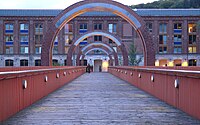
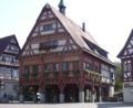
Esslingen am Neckar is a town in the Stuttgart Region of Baden-Württemberg in southern Germany, seat of the District of Esslingen as well as the largest town in the district. Within Baden-Württemberg it is the 11th largest city.

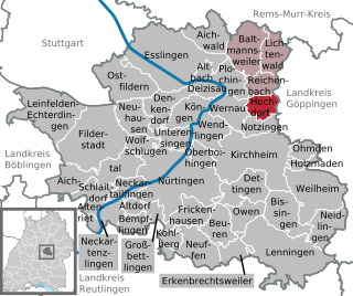
Esslingen is a Landkreis (district) in the centre of Baden-Württemberg, Germany. Neighboring districts are Rems-Murr, Göppingen, Reutlingen, Böblingen and the district-free city Stuttgart.

<span class="mw-page-title-main">Reichenbach an der Fils</span> Municipality in Baden-Württemberg, Germany

Reichenbach an der Fils is a town in the Esslingen district in Baden-Württemberg in southern Germany.

<span class="mw-page-title-main">Wernau</span> Town in Baden-Württemberg, Germany

Wernau is a town in the district of Esslingen in Baden-Württemberg southwestern Germany. It is situated on the Neckar river, 25 km southeast of Stuttgart.

<span class="mw-page-title-main">Denkendorf, Baden-Württemberg</span> Municipality in Baden-Württemberg, Germany

Denkendorf is a municipality in the district of Esslingen in Baden-Württemberg in southern Germany. It is located 5 km south of Esslingen, and 14 km southeast of Stuttgart.

<span class="mw-page-title-main">Altbach</span> Municipality in Baden-Württemberg, Germany

Altbach is a municipality in the district of Esslingen in Baden-Württemberg. It belongs to the Stuttgart Region. and the European Metropolitan Region Stuttgart.

<span class="mw-page-title-main">Baltmannsweiler</span> Municipality in Baden-Württemberg, Germany

Baltmannsweiler is a municipality in the district of Esslingen in Baden-Württemberg. It belongs to the Region Stuttgart. and the European Metropolitan Region Stuttgart.

<span class="mw-page-title-main">Deizisau</span> Town in Baden-Württemberg, Germany

Deizisau is a town in the district of Esslingen in Baden-Württemberg in southern Germany. It belongs to the Stuttgart Region (until 1992 Region Mittlerer Neckar) and the Stuttgart Metropolitan Region. Deizisau is located between the towns of Plochingen and Esslingen am Neckar, about 20 kilometers southeast of Stuttgart, the capital of Baden-Württemberg. The river Neckar flows through this town.

<span class="mw-page-title-main">Hochdorf, Esslingen</span> Municipality in Baden-Württemberg, Germany

Hochdorf is a municipality in the district of Esslingen, Baden-Württemberg, in southern Germany. The mayors are Roland Erhardt and Gerhart Kuttler.

<span class="mw-page-title-main">Köngen</span> Municipality in Baden-Württemberg, Germany

Köngen is a municipality in the district of Esslingen in Baden-Württemberg in Germany. About nine kilometers from the district city Esslingen am Neckar and about six kilometers away from Nürtingen. It is part of the Stuttgart Region and the European Stuttgart Metropolitan Region.

<span class="mw-page-title-main">Lichtenwald</span> Municipality in Baden-Württemberg, Germany

Lichtenwald is a municipality located in the Schurwald forest in the district of Esslingen in Baden-Württemberg in southern Germany. Situated on the state road L1151 between Reichenbach an der Fils and Schorndorf. It belongs to the Stuttgart Region and the European metropolitan region of Stuttgart.

<span class="mw-page-title-main">Fils Valley Railway</span> Train line in Baden-Württemburg

The Fils Valley Railway designates the Württemberg line from Stuttgart via Göppingen to Ulm. It runs from Plochingen to Geislingen an der Steige through the Fils Valley.

<span class="mw-page-title-main">Schurwald</span>

The Schurwald is a wooded mountain range in Baden-Württemberg, southern Germany, which at its highest point is 513.2 m above sea level.

The Plochingen–Immendingen railway is a main-line railway line in the German state of Baden-Württemberg. It runs from Plochingen via Horb am Neckar to Immendingen, following the upper reaches of the Neckar from Plochingen to Neckartailfingen and from Kirchentellinsfurt to Rottweil, and finally the Danube from Tuttlingen to the end of the line. It was therefore also historically known as the Obere Neckarbahn or the Obere Neckartalbahn. The Rottweil-Immendingen section used to be called the Obere Donaubahn or Obere Donautalbahn.

<span class="mw-page-title-main">Esslingen (Neckar) station</span> Railway station in Germany

Esslingen (Neckar) station is the most important station in the town of Esslingen am Neckar in the German state of Baden-Württemberg and is located 13.2 kilometres (8.2 mi) from Stuttgart Hauptbahnhof on the Fils Valley Railway.

<span class="mw-page-title-main">Plochingen station</span>

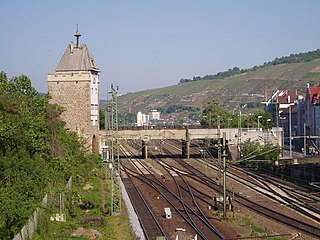
Plochingen station is the only station in the town of Plochingen in the German state of Baden-Württemberg and the most important railway junction of the Esslingen district. It is located 22.8 kilometres from Stuttgart Hauptbahnhof on the Fils Valley Railway and at the beginning of the Plochingen–Immendingen railway.

<span class="mw-page-title-main">Esslingen (electoral district)</span> Federal electoral district of Germany

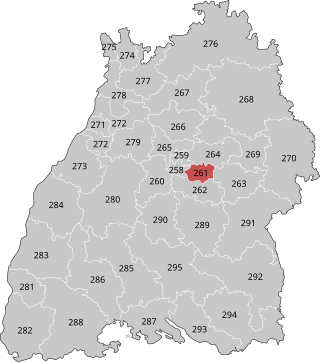
Esslingen is an electoral constituency represented in the Bundestag. It elects one member via first-past-the-post voting. Under the current constituency numbering system, it is designated as constituency 261. It is located in central Baden-Württemberg, comprising the northern part of the Esslingen district.

<span class="mw-page-title-main">Nürtingen (electoral district)</span> Federal electoral district of Germany

Nürtingen is an electoral constituency represented in the Bundestag. It elects one member via first-past-the-post voting. Under the current constituency numbering system, it is designated as constituency 262. It is located in central Baden-Württemberg, comprising the southern part of the Esslingen district.

<span class="mw-page-title-main">Old Neckar</span> Nature reserve in Baden-Württemberg, Germany

Old Neckar is a nature conservation area designated by decree of the Regional Council Stuttgart on the territory of the municipality Altbach and the town Esslingen in the district of Esslingen in Baden-Württemberg. A 16.0-hectare (40-acre) area had already been placed under protection by decree of December 2, 1985.

References

  1. 1 2 Bürgermeisterwahl Plochingen 2024, Staatsanzeiger. Retrieved 12 June 2024.
  2. "Bevölkerung nach Nationalität und Geschlecht am 31. Dezember 2022" [Population by nationality and sex as of December 31, 2022](CSV) (in German). Statistisches Landesamt Baden-Württemberg. June 2023.
  3. Das Land Baden-Württemberg. Amtliche Beschreibung nach Kreisen und Gemeinden. Band III: Regierungsbezirk Stuttgart, Regionalverband Mittlerer Neckar. Kohlhammer, Stuttgart 1978, ISBN   3-17-004758-2, S. 236–237.
  4. Statistisches Landesamt, Fläche seit 1988 nach tatsächlicher Nutzung für Plochingen.
  5. Leo BW Plochingen Altgemeinde - Ortslage und Siedlung
  6. Burgen und Schlösser des Landkreises Esslingen at the Wayback Machine (archived 2008-04-24)
  7. 1 2 Max Miller, Gerhard Taddey (Hrsg.): Handbuch der historischen Stätten Deutschlands. Band 6: Baden-Württemberg (= Kröners Taschenausgabe. Band 276). 2., verbesserte und erweiterte Auflage. Kröner, Stuttgart 1980, ISBN   3-520-27602-X, S. 634.
  8. Leo BW Plochingen Altgemeinde – Kirche und Religion
  9. Abbildung von 1905 einsehbar auf
  10. Stadt Plochingen – Aus der Geschichte Archived 2013-05-18 at the Wayback Machine . Retrieved 15 January 2013.
  11. "Behördenwegweiser".
  12. "Eigenbetriebe der Stadt Plochingen".
  13. Election information of the municipal computer centre
  14. "Partnerstädte". plochingen.de (in German). Plochingen. Retrieved 2021-03-11.