
The Llano Estacado, sometimes translated into English as the Staked Plains, is a region in the Southwestern United States that encompasses parts of eastern New Mexico and northwestern Texas. One of the largest mesas or tablelands on the North American continent, the elevation rises from 3,000 feet (900 m) in the southeast to over 5,000 feet (1,500 m) in the northwest, sloping almost uniformly at about 10 feet per mile (2 m/km).

The Santa Fe Trail was a 19th-century route through central North America that connected Franklin, Missouri, with Santa Fe, New Mexico. Pioneered in 1821 by William Becknell, who departed from the Boonslick region along the Missouri River, the trail served as a vital commercial highway until 1880, when the railroad arrived in Santa Fe. Santa Fe was near the end of El Camino Real de Tierra Adentro which carried trade from Mexico City. The trail was later incorporated into parts of the National Old Trails Road and U.S. Route 66.

El Capitan is a peak in Culberson County, Texas, located within Guadalupe Mountains National Park. The 10th-highest peak in Texas at 8,085 ft, El Capitan is part of the Guadalupe Mountains, an exposed portion of a Permian period reef uplifted and exposed by tectonic activity during the late Cretaceous period. The southern terminus of the Guadalupe Mountains, El Capitan looms over U.S. 62/180, where its imposing height and stark outline have made it one of the iconic images of the Trans-Pecos to generations of travelers.

The Comanche Wars were a series of armed conflicts fought between Comanche peoples and Spanish, Mexican, and American militaries and civilians in the United States and Mexico from as early as 1706 until at least the mid-1870s. The Comanche were the Native American inhabitants of a large area known as Comancheria, which stretched across much of the southern Great Plains from Colorado and Kansas in the north through Oklahoma, Texas, and eastern New Mexico and into the Mexican state of Chihuahua in the south. For more than 150 years, the Comanche were the dominant native tribe in the region, known as “the Lords of the Southern Plains”, though they also shared parts of Comancheria with the Wichita, Kiowa, and Kiowa Apache and, after 1840, the southern Cheyenne and Arapaho.

The Comancheria or Comanchería was a region of New Mexico, west Texas and nearby areas occupied by the Comanche before the 1860s. Historian Pekka Hämäläinen has argued that the Comancheria formed an empire at its peak, and this view has been echoed by other non-Comanche historians.
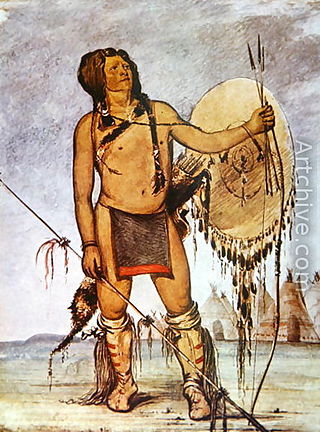
Comanche history – in the 18th and 19th centuries the Comanche became the dominant tribe on the southern Great Plains. The Comanche are often characterized as "Lords of the Plains." They presided over a large area called Comancheria which they shared with allied tribes, the Kiowa, Kiowa-Apache, Wichita, and after 1840 the southern Cheyenne and Arapaho. Comanche power and their substantial wealth depended on horses, trading, and raiding. Adroit diplomacy was also a factor in maintaining their dominance and fending off enemies for more than a century. They subsisted on the bison herds of the Plains which they hunted for food and skins.
Buffalo Hump was a War Chief of the Penateka band of the Comanches. He came to prominence after the Council House Fight when he led the Comanches on the Great Raid of 1840.
The Texas–Indian wars were a series of conflicts between settlers in Texas and the Southern Plains Indians during the 19th-century. Conflict between the Plains Indians and the Spanish began before other European and Anglo-American settlers were encouraged—first by Spain and then by the newly Independent Mexican government—to colonize Texas in order to provide a protective-settlement buffer in Texas between the Plains Indians and the rest of Mexico. As a consequence, conflict between Anglo-American settlers and Plains Indians occurred during the Texas colonial period as part of Mexico. The conflicts continued after Texas secured its independence from Mexico in 1836 and did not end until 30 years after Texas became a state of the United States, when in 1875 the last free band of Plains Indians, the Comanches led by Quahadi warrior Quanah Parker, surrendered and moved to the Fort Sill reservation in Oklahoma.
Santa Anna was a Native American war chief of the Penateka tribe of the Comanche Indians.
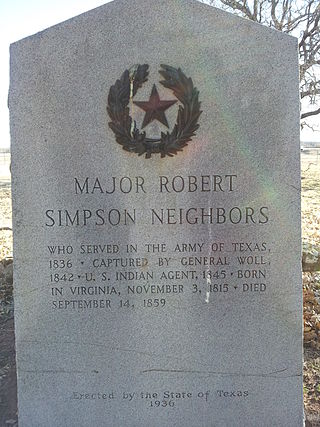
Robert Simpson Neighbors was an Indian agent and Texas state legislator. Known as a fair and determined protector of Indian interests as guaranteed by treaty, he was murdered by a white man named Cornet, whose brother-in-law had been defamed by Neighbors, accusing the brother-in-law a common horse thief, responsible for stealing horses from the reservation Indians. When Neighbors refused to recant the accusation in front of the two men, Cornet shot Neighbors with a shotgun. Cornet was murdered and Murphy acquitted as he did not pull the trigger. Cornet went on the run and was killed during his arrest.

The Meusebach–Comanche Treaty was a treaty made on May 9, 1847 between the private citizens of the Fisher–Miller Land Grant in Texas, who were predominantly German in nationality, and the Penateka Comanche Tribe. The treaty was officially recognized by the United States government. In 1936, a Recorded Texas Historic Landmark, Marker number 991, was placed in San Saba County to commemorate the signing of the treaty.

Horsehead Crossing is a ford on the Pecos River in Crane County, south of Odessa, Texas. Historically, it was a major landmark on the trail west as one of a few fordable sections of the Pecos in West Texas, and as the first reliable source of water for about 75 miles on the route from the east.
The San Antonio–El Paso Road, also known as the Lower Emigrant Road or Military Road, was an economically important trade route between the Texas cities of San Antonio and El Paso between 1849 and 1882. Mail, freight, and passengers traveled by horse and wagon along this road across the Edwards Plateau and dangerous Trans-Pecos region of West Texas.
In the history of the American frontier, pioneers built overland trails throughout the 19th century, especially between 1840 and 1847 as an alternative to sea and railroad transport. These immigrants began to settle much of North America west of the Great Plains as part of the mass overland migrations of the mid-19th century. Settlers emigrating from the eastern United States did so with various motives, among them religious persecution and economic incentives, to move from their homes to destinations further west via routes such as the Oregon, California, and Mormon Trails. After the end of the Mexican–American War in 1849, vast new American conquests again encouraged mass immigration. Legislation like the Donation Land Claim Act and significant events like the California Gold Rush further encouraged settlers to travel overland to the west.
Pedro Vial, or Pierre Vial, was a French explorer and frontiersman who lived among the Comanche and Wichita Indians for many years. He later worked for the Spanish government as a peacemaker, guide, and interpreter. He blazed trails across the Great Plains to connect the Spanish and French settlements in Texas, New Mexico, Missouri, and Louisiana. He led three Spanish expeditions that attempted unsuccessfully to intercept and halt the Lewis and Clark Expedition.
Tunas Spring, formerly Escondido Spring, a spring along Tunas Creek, a tributary of the Pecos River in Pecos County, Texas.
Leaving of Pecos was originally a camping place along the west bank of the Pecos River, on the wagon road called the Lower Emigrant Road, Military Road or San Antonio-El Paso Road in Texas. It was located 38 miles north of the Lancaster Crossing of the Pecos, and 16 miles east of the first crossing of Escondido Creek. It was also located a mile north of where the wagon road had its junction with a cutoff to the north to the wagon road called the Upper Emigrant Road between Fredericksburg, Texas and Comanche Springs, now Fort Stockton, Texas, where it joined the Lower Emigrant Road. It was later a stopping place on the route of San Antonio - El Paso Mail and the San Antonio-San Diego Mail Line.

Dead Man's Walk is an American epic Western adventure television miniseries starring David Arquette as Augustus McCrae and Jonny Lee Miller as Woodrow F. Call. It was directed by Yves Simoneau. It is a two-part adaptation of the 1995 novel of the same name by Larry McMurtry and is chronologically the third book of the Lonesome Dove series, but regarded as the first events in the Lonesome Dove franchise. In this prequel to Lonesome Dove, it is 1840s Texas, and two young men join the Texas Rangers unit that's on a mission to annex Santa Fe. While the miniseries has been broken up into 3 parts for the DVD release, the series was originally broadcast by ABC over two nights in May 1996, and was later nominated for several awards.
Comanche Springs was an aquifer of six artesian springs geographically located between the Edwards Plateau and the Trans-Pecos regions of West Texas. The military fortification Camp Stockton was built around the springs, eventually growing become the city of Fort Stockton.
Yellow Wolf, Spirit Talker 's nephew and Buffalo Hump 's cousin and best support, was a War Chief of the Penateka division of the Comanche Indians. He came to prominence after the Council House Fight, when Buffalo Hump called the Comanches and, along with Yellow Wolf and Santa Anna, led them in the Great Raid of 1840.