Related Research Articles

The geography of New Caledonia (Nouvelle-Calédonie), an overseas collectivity of France located in the subregion of Melanesia, makes the continental island group unique in the southwest Pacific. Among other things, the island chain has played a role in preserving unique biological lineages from the Mesozoic. It served as a waystation in the expansion of the predecessors of the Polynesians, the Lapita culture. Under the Free French it was a vital naval base for Allied Forces during the War in the Pacific.

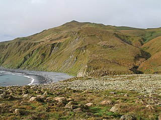
The Auckland Islands are an archipelago of New Zealand, lying 465 km (289 mi) south of the South Island. The main Auckland Island, occupying 460 km2 (180 sq mi), is surrounded by smaller Adams Island, Enderby Island, Disappointment Island, Ewing Island, Rose Island, Dundas Island, and Green Island, with a combined area of 570 km2 (220 sq mi). The islands have no permanent human inhabitants.

A biogeographic realm is the broadest biogeographic division of Earth's land surface, based on distributional patterns of terrestrial organisms. They are subdivided into bioregions, which are further subdivided into ecoregions. A biogeographic realm is also known as "ecozone", although that term may also refer to ecoregions.
Miklós Dezso Ferenc Udvardy was a distinguished Hungarian-born Canadian biologist who made significant contributions to the fields of biogeography, evolutionary biology, ornithology, and vegetation classification. His research on biogeographical provinces, as outlined in his influential work "A Classification of the Biogeographical Provinces of the World," provided a foundational framework for understanding the distribution of species and ecosystems.

The Australasian realm is one of eight biogeographic realms that is coincident with, but not the same as, the geographical region of Australasia. The realm includes Australia, the island of New Guinea, and the eastern part of the Indonesian archipelago, including the island of Sulawesi, the Moluccas, and the islands of Lombok, Sumbawa, Sumba, Flores, and Timor, often known as the Lesser Sundas.

The Oceanian realm is one of the eight biogeographic realms and is unique in not including any continental land mass. It has the smallest land area of any of the WWF realms.

Campbell Island / Motu Ihupuku is an uninhabited subantarctic island of New Zealand, and the main island of the Campbell Island group. It covers 112.68 square kilometres (43.51 sq mi) of the group's 113.31 km2 (43.75 sq mi), and is surrounded by numerous stacks, rocks and islets like Dent Island, Folly Island, Isle de Jeanette-Marie, and Jacquemart Island, the latter being the southernmost extremity of New Zealand. The island is mountainous, rising to over 500 metres (1,640 ft) in the south. A long fiord, Perseverance Harbour, nearly bisects it, opening out to sea on the east coast.

The biodiversity of New Caledonia is of exceptional biological and paleoecological interest. It is frequently referred to as a biodiversity hotspot. The country is a large South Pacific archipelago with a total land area of more than 18,000 square kilometres (6,900 sq mi). The terrain includes a variety of reefs, atolls, small islands, and a variety of topographical and edaphic regions on the largest island, all of which promote the development of unusually concentrated biodiversity. The region's climate is oceanic and tropical.
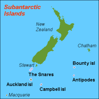
The New Zealand Subantarctic Islands comprise the five southernmost groups of the New Zealand outlying islands. They are collectively designated as a UNESCO World Heritage Site.

The New Caledonia rain forests are a terrestrial ecoregion, located in New Caledonia in the South Pacific. It is a tropical moist broadleaf forest ecoregion, part of the Australasian realm.
The Antipodes Subantarctic Islands tundra ecoregion, within the tundra biome, includes five remote island groups in the Pacific Ocean south of New Zealand: the Bounty Islands, Auckland Islands, Antipodes Islands and Campbell Island groups of New Zealand, and Macquarie Island of Australia.

The biodiversity of New Zealand, a large island country located in the south-western Pacific Ocean, is varied and distinctive. The species of New Zealand accumulated over many millions of years as lineages evolved in the local circumstances. New Zealand's pre-human biodiversity exhibited high levels of species endemism, but has experienced episodes of biological turnover. Global extinction approximately 65 Ma resulted in the loss of fauna such as non-avian dinosaurs, pterosaurs and marine reptiles e.g. mosasaurs, elasmosaurs and plesiosaurs. The ancient fauna is not well known, but at least one species of terrestrial mammal existed in New Zealand around 19 Ma. For at least several million years before the arrival of human and commensal species, the islands had no terrestrial mammals except for bats and seals, the main component of the terrestrial fauna being insects and birds. As recently as the 14th century a component has been introduced by humans, including many terrestrial mammals.

The Campbell Plateau is a large oceanic plateau south of New Zealand and the Chatham Rise. It originated in the Gondwanan breakup and is part of Zealandia, a largely submerged continent. The above sea level parts of the plateau — the Bounty Islands, Antipodes Islands, Auckland Islands and Campbell Island — form part of the New Zealand Subantarctic Islands which were declared a World Heritage Site in 1998. Large parts of the Campbell Plateau lie less than 1000 m below sea level. It rises to 500 m at the Pukaki Rise and emerges above sea level at the Auckland and Campbell Islands.

The New Zealand outlying islands are nine offshore island groups that are part of New Zealand, with all but Solander Islands lying beyond the 12nm limit of the mainland's territorial waters. Although considered integral parts of New Zealand, seven of the nine island groups are not part of any administrative region or district, but are instead each designated as an Area Outside Territorial Authority. The two exceptions are the Chatham Islands, which are covered by their own special territorial authority, and the Solander Islands, which are part of the Southland Region and Southland District.
Insulantarctica is a biogeographic province of the Antarctic Realm according to the classification developed by Miklos Udvardy in 1975. It comprises scattered islands of the Southern Ocean, which show clear affinity to each other. These islands belong to different countries. Some of them constitute UNESCO's protected areas.

The Antarctic Floristic Kingdom, also the Holantarctic Kingdom, is a floristic kingdom that includes most areas of the world south of 40°S latitude. It was first identified by botanist Ronald Good, and later by Armen Takhtajan. The Antarctic Floristic Kingdom is a classification in phytogeography, different from the Antarctic realm classification in biogeography, and from Antarctic flora genera/species classifications in botany.
The natural history of New Zealand began when the landmass Zealandia broke away from the supercontinent Gondwana in the Cretaceous period. Before this time, Zealandia shared its past with Australia and Antarctica. Since this separation, the New Zealand landscape has evolved in physical isolation, although much of its current biota has more recent connections with species on other landmasses. The exclusively natural history of the country ended in about 1300 AD, when humans first settled, and the country's environmental history began. The period from 1300 AD to today coincides with the extinction of many of New Zealand's unique species that had evolved there.

Zealandia, also known as Te Riu-a-Māui (Māori) or Tasmantis, is an almost entirely submerged mass of continental crust in Oceania that subsided after breaking away from Gondwana 83–79 million years ago. It has been described variously as a submerged continent, continental fragment, and microcontinent. The name and concept for Zealandia was proposed by Bruce Luyendyk in 1995, and satellite imagery shows it to be almost the size of Australia. A 2021 study suggests Zealandia is over a billion years old, about twice as old as geologists previously thought.
Biogeographic classification of India is the division of India according to biogeographic characteristics. Biogeography is the study of the distribution of species (biology), organisms, and ecosystems in geographic space and through geological time. India has a rich heritage of natural diversity. India ranks fourth in Asia and tenth in the world amongst the top 17 mega-diverse countries in the world. India harbours nearly 11% of the world's floral diversity comprising over 17500 documented flowering plants, 6200 endemic species, 7500 medicinal plants and 246 globally threatened species in only 2.4% of world's land area. India is also home to four biodiversity hotspots—Andaman & Nicobar Islands, Eastern Himalaya, Indo-Burma region, and the Western Ghats. Hence the importance of biogeographical study of India's natural heritage.
References
- ↑ Udvardy, M. D. F. (1975). A Classification of the Biogeographical Provinces of the World. Morges, Switzerland: IUCN.
- ↑ Udvardy, Miklos D. F. (1975). World Biogeographical Provinces (Map). Sausalito, California: CoEvolution.
- ↑ Nature: Land of the Kiwi, PBS Video, 1987