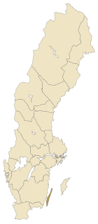
The Kattegat is a 30,000 km2 (12,000 sq mi) sea area bounded by the Jutlandic peninsula in the west, the Danish Straits islands of Denmark to the south and the provinces of Västergötland, Scania, Halland and Bohuslän in Sweden in the east. The Baltic Sea drains into the Kattegat through the Danish Straits. The sea area is a continuation of the Skagerrak and may be seen as a bay of the Baltic Sea or the North Sea or, as in traditional Scandinavian usage, neither of these.

Blå Jungfrun, also known as "Blåkulla", in English sometimes rendered literally as The Blue Maiden is a Swedish island in the Baltic Sea. It is situated in the Kalmar Strait, between the mainland province of Småland and the island province of Öland. Administratively, the uninhabited island is part of the municipality of Oskarshamn and covers an area of approximately 0.7 km2 (0.27 sq mi) with a mean height above sea level of 86 m (282 ft). Home to black guillemots and a Swedish National Park since 1926, freedom to roam at Blå Jungfrun is limited with visitors prohibited from staying overnight on the island or making fires.

Long Meg and Her Daughters is a Bronze Age stone circle near Penrith in Cumbria, North West England. One of around 1,300 stone circles in the British Isles and Brittany, it was constructed as a part of a megalithic tradition that lasted from 3,300 to 900 BCE, during the Late Neolithic and Early Bronze Age. The stone circle is the sixth-largest example known from this part of north-western Europe, being slightly smaller than the rings at Stanton Drew in Somerset, the Ring of Brodgar in Orkney and Newgrange in County Meath.

The Neptune Islands consist of two groups of islands located close to the entrance to Spencer Gulf in South Australia. They are well known as a venue for great white shark tourism.

The stone ship or ship setting was an early burial custom in Scandinavia, Northern Germany and the Baltic states. The grave or cremation burial was surrounded by slabs or stones in the shape of a ship. The ships vary in size and were erected from c. 1000 BC to 1000 AD.

Swinside, which is also known as Sunkenkirk and Swineshead, is a stone circle lying beside Swinside Fell, part of Black Combe in southern Cumbria, North West England. One of around 1,300 recorded stone circles in the British Isles and Brittany, it was constructed as a part of a megalithic tradition that lasted from 3,300 to 900 BC, during what archaeologists categorise as the Late Neolithic and Early Bronze Ages.

Stora Alvaret is an alvar, a barren limestone terrace, in the southern half of the island of Öland, Sweden. Stora Alvaret is a dagger shaped expanse almost 40 kilometres (25 mi) long and about 10 kilometres (6.2 mi) at the widest north end. The area of this formation exceeds 260 square kilometres (100 sq mi), making it the largest such expanse in Europe and comprising over one fourth of the land area of the island.
Ottenby is a town on the island of Öland, Sweden, located in Ås parish, Mörbylånga Municipality in Kalmar County. Ottenby is located just north of the southern tip of Öland, over three miles south of the area's main town, Mörbylånga. Ottenby is also the name of the mansion and a royal demesne, now a nature reserve.

The geology of Cornwall, England, is dominated by its granite backbone, part of the Cornubian batholith, formed during the Variscan orogeny. Around this is an extensive metamorphic aureole formed in the mainly Devonian slates that make up most of the rest of the county. There is an area of sandstone and shale of Carboniferous age in the north east, and the Lizard peninsula is formed of a rare section of uplifted oceanic crust.

Tievebulliagh is a 554-metre-high (1,818 ft) mountain in the Glens of Antrim, Northern Ireland. It forms part of the watershed between Glenaan to the north and Glenballyemon to the south. It is situated about 4.4 km from Cushendall.

Cay Sal Bank is the third largest and the westernmost of the Bahama Banks. It is located between 23º27'N - 24º10'N and 079º25'W – 080º35'W. In a geographical sense, it is separate from the Bahamas proper as it is much closer to Cuba than to the closest Bahamanian island. It is separated by Santaren Channel from the Great Bahama Bank, the western rim of which is 50 km (31 mi) to the east. The Straits of Florida separate it from the United States mainland and the Florida Keys.

Rough Tor, or Roughtor, is a tor on Bodmin Moor, Cornwall, United Kingdom. The site is composed of the tor summit and logan stone, a neolithic tor enclosure, a large number of Bronze Age hut circles, and some contemporary monuments.

Torsburgen, Tors borg or þors borg are the remains of an ancient hillfort in Kräklingbo on the Swedish island of Gotland in the Baltic Sea. The fort is approximately 1.2 km2 (0.46 sq mi), was constructed in the 1st-4th century and in use until the 12th century. Situated on a plateau hill it is protected by high cliffs and wall sections, almost 2 km (1.2 mi) long in total. The fort is featured in the Gutasaga. The plateau is also a nature reserve.

Kräklingbo is a populated area, a socken, on the Swedish island of Gotland. It comprises the same area as the administrative Kräklingbo District, established on 1 January 2016.
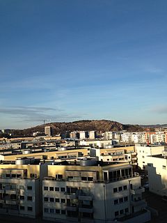
Ramberget is a mountain on Hisingen island in Gothenburg, Sweden. The surrounding area and park is called Keillers Park. Ramberget is a popular tourist attraction and a place for outdoor recreation for Gothenburg residents, with walking paths, lookouts over the city of Gothenburg and artworks. Ramberget is with its highest point 87 metres (282 ft) above sea level, with a lower second point called Ättestupan. There is a road for cars going to the top of Ramberget. The park is about 31 hectares.

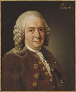
Heligholmen is an island off the south coast of Vamlingbo, Gotland, Sweden, with an area of 11.8 hectares. It is uninhabited and its only building is a small lighthouse. Heligholmen is a bird reserve. In 1741, Carl Linnaeus, visited the island and described it in his book Öländska och Gothländska Resa.

Saint Olaf's chapel in Byxelkrok, on the island of Öland, Sweden, was built in 1976. The modernist design is by Anders Berglund. The chapel is in Böda socken in the Diocese of Växjö, and is one of three 20th century churches on the island.

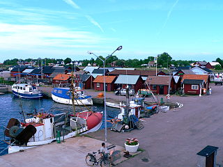
Gnisvärd, is a fishing village in Tofta on the central west coast of the island of Gotland, Sweden. Gnisvärd is mostly known for its stone ships and harbor.

The Penrhos Feilw Standing Stones are a pair of standing stones on Holy Island west of Anglesey in north-west Wales. They are thought to date from the Bronze Age but their origins and purpose are unclear. They are about 3 m (10 ft) high and are a similar distance apart.