
Lake Michigan is one of the five Great Lakes of North America and the only one located entirely within the United States. The other four Great Lakes are shared by the U.S. and Canada. It is the second-largest of the Great Lakes by volume and the third-largest by surface area, after Lake Superior and Lake Huron. To the east, its basin is conjoined with that of Lake Huron through the wide Straits of Mackinac, giving it the same surface elevation as its easterly counterpart; the two are technically a single lake.

Churchill County is a county in the western U.S. state of Nevada. As of the 2010 United States Census, the population was 24,877. Its county seat is Fallon. The county, named for Mexican–American War hero brevet Brigadier General Sylvester Churchill, was formed in 1861.

Washburn County is a county in the U.S. state of Wisconsin. It is named after Governor Cadwallader C. Washburn. As of the 2010 census, the population was 15,911. Its county seat is Shell Lake. The county was created in 1883.

Neptune Township is a township in Monmouth County, New Jersey, in the United States. As of the 2010 United States Census, the township's population was 27,935, reflecting an increase of 245 (+0.9%) from the 27,690 counted in the 2000 Census, which had in turn declined by 458 (-1.6%) from the 28,148 counted in the 1990 Census.

Villenova is a town in Chautauqua County, New York, United States. The population was 1,110 at the 2010 census. The town is on the eastern border of the county and is southeast of Dunkirk.
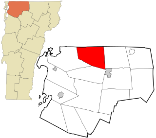
Franklin is a town in Franklin County, Vermont, United States. The population was 1,405 at the 2010 census, up from 1,268 at the 2000 census.

Crystal Lake is a town in Barron County in the U.S. state of Wisconsin. The population was 757 at the 2010 census. The unincorporated community of Comstock is located in the town.

Almena is a town in Barron County in the U.S. state of Wisconsin. The population was 858 at the 2010 census. The Village of Almena is partially located within the town.
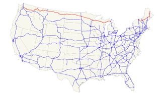
U.S. Route 2 or U.S. Highway 2 (US 2) is an east–west U.S. Highway spanning 2,571 miles (4,138 km) across the northern continental United States. US 2 consists of two segments connected by various roadways in southern Canada. Unlike some routes, which are disconnected into segments because of encroaching Interstate Highways, the two portions of US 2 were designed to be separate in the original 1926 highway plan.
U.S. Highway 8 (US 8) is a United States Numbered Highway that runs primarily east–west for 280 miles (451 km), mostly within the state of Wisconsin. It connects Interstate 35 (I-35) in Forest Lake, Minnesota, to US 2 at Norway in the Upper Peninsula of Michigan near the border with Wisconsin. Except for the short freeway segment near Forest Lake, and sections near the St. Croix River bridge and Rhinelander, Wisconsin, it is mostly undivided surface road. As a state highway in the three states, US 8 is maintained by the Minnesota, Wisconsin and Michigan departments of transportation.
Interstate 41 (I-41) is a 176.33-mile-long (283.78 km) Interstate Highway connecting the interchange of I-94 and U.S. Route 41, located 0.9 miles (1.4 km) south of the Wisconsin–Illinois border at the end of the Tri-State Tollway in metropolitan Chicago, to an interchange with I-43 in metropolitan Green Bay, Wisconsin. The designation travels concurrently with US 41, I-894, US 45, I-43, and sections of I-94 in Wisconsin and Illinois. The route was officially added to the Interstate Highway System on April 7, 2015, and connects Milwaukee and Green Bay with the Fox Cities.
The Kettle Moraine State Forest is a state forest in southeastern Wisconsin. The chief feature of the reserve is the Kettle Moraine, a highly glaciated area. The area contains very hilly terrain and glacial landforms, such as kettles, kames and eskers. The 56,000-acre (23,000 ha) forest is divided into two large and three small units, which are spread across a hundred miles.

Dublin Pond or Dublin Lake is a 236-acre (0.96 km2) water body located in Cheshire County in southwestern New Hampshire, United States, in the town of Dublin. The pond lies at an elevation of 1,480 feet (451 m) above sea level, near the height of land between the Connecticut River/Long Island Sound watershed to the west and the Merrimack River/Gulf of Maine watershed to the east.
Bass Lake is a census-designated place in Madera County, California. It is located 4.5 miles (7.2 km) southeast of Yosemite Forks, at an elevation of 3415 feet. The population was 527 at the 2010 census.
Johnson Creek is a minor tributary of the Rock River, about 20.8 miles (33.5 km) long, in southeastern Wisconsin in the United States. Via the Rock River, it is part of the watershed of the Mississippi River. Its watershed lies entirely within Jefferson County.

Mars Lake is a small spring-fed rural lake in Oneida County in northern Wisconsin in the United States, near the intersection of U.S. Route 45 and U.S. Route 8, about 4.5 miles (7.2 km) north of Pelican Lake and 2,000 feet (610 m) northwest of the small settlement of Monico. It is located between the somewhat larger lakes Neptune Lake and Venus Lake.

Venus Lake is a small mesotrophic rural lake in Oneida County in northern Wisconsin in the United States, at the intersection of U.S. Route 45 and U.S. Route 8, about 4 miles (6.4 km) north of Pelican Lake and adjacent to the small settlement of Monico. The slightly smaller Mars Lake and the somewhat larger Neptune Lake are nearby, to the northwest.
Siskiwit Lake is a small eutrophic lake on the Bayfield Peninsula in Bayfield County in northern Wisconsin in the United States. The lake is located about 4.5 miles (7.2 km) south of Siskiwit Bay, an arm of Lake Superior, and about 2 miles (3.2 km) north of the northern boundary of Chequamegon National Forest. Duluth-Superior is about 48 miles (77 km) to the west. Parts of the small town of Bell border the lake, and there are several houses and vacation cabins on the lake, most on the north shore. The nearest major road, Wisconsin Highway 13, is about 3.5 miles (5.6 km) to the north, and the nearest large town, Washburn, is about 14 miles (23 km) to the southeast, down County Highway C.

The Wisconsin State Trunk Highway System is the state highway system of the U.S. state of Wisconsin, including Wisconsin's segments of the Interstate Highway System and the United States Numbered Highway System, in addition to its other state trunk highways. These separate types of highways are respectively designated with an I-, US, or STH- prefix. The system also includes minor roads designated as Scenic Byways, four routes intended to promote tourism to scenic and historic areas of the state; and as Rustic Roads, lightly-traveled and often unpaved local roads which the state has deemed worthy of preservation and protection. The state highway system, altogether totaling 11,753 miles (18,915 km) across all of Wisconsin's 72 counties, is maintained by the Wisconsin Department of Transportation (WisDOT).


