
Lake Michigan is one of the five Great Lakes of North America and the only one located entirely within the United States. The other four Great Lakes are shared by the U.S. and Canada. It is the second-largest of the Great Lakes by volume and the third-largest by surface area, after Lake Superior and Lake Huron. To the east, its basin is conjoined with that of Lake Huron through the wide Straits of Mackinac, giving it the same surface elevation as its easterly counterpart; the two are technically a single lake.

Lake Superior, the largest of the Great Lakes of North America, is also the world's largest freshwater lake by surface area, and the third largest freshwater lake by volume. The lake is shared by the Canadian province of Ontario to the north, the U.S. state of Minnesota to the west, and Wisconsin and the Upper Peninsula of Michigan to the south. The farthest north and west of the Great Lakes chain, Superior has the highest elevation of all five great lakes and drains into the St. Mary's River.

The Mississippi River is the second-longest river and chief river of the second-largest drainage system on the North American continent, second only to the Hudson Bay drainage system. Its source is Lake Itasca in northern Minnesota and it flows generally south for 2,320 miles (3,730 km) to the Mississippi River Delta in the Gulf of Mexico. With its many tributaries, the Mississippi's watershed drains all or parts of 32 U.S. states and two Canadian provinces between the Rocky and Appalachian mountains. The main stem is entirely within the United States; the total drainage basin is 1,151,000 sq mi (2,980,000 km2), of which only about one percent is in Canada. The Mississippi ranks as the fourth-longest and fifteenth-largest river by discharge in the world. The river either borders or passes through the states of Minnesota, Wisconsin, Iowa, Illinois, Missouri, Kentucky, Tennessee, Arkansas, Mississippi, and Louisiana.

Pittsburg is a town in Coos County, New Hampshire, United States. The population was 869 at the 2010 census. It is the northernmost town in New Hampshire and the largest town by area in the state – and in New England as well – more than twice the size of the next largest town, Lincoln. U.S. Route 3 is the only major highway in the town, although the northern terminus of New Hampshire Route 145 also lies within Pittsburg.

Muskego is a city in Waukesha County, Wisconsin, United States. As of the 2010 census, the city had a population of 24,135. Muskego is the fifth largest community in Waukesha County. The name Muskego is derived from the Potawatomi Indian name for the area, "Mus-kee-Guaac", meaning sunfish. The Potawatomi were the original inhabitants of Muskego. There are three lakes within the city's boundaries.

Lake Mead is a man made lake that lies on the Colorado River, about 24 mi (39 km) from the Las Vegas Strip, southeast of the city of Las Vegas, Nevada, in the states of Nevada and Arizona. It is the largest reservoir in the United States in terms of water capacity. Formed by the Hoover Dam on September 30, 1935, the reservoir serves water to the states of Arizona, California, and Nevada, as well as some of Mexico, providing sustenance to nearly 20 million people and large areas of farmland.
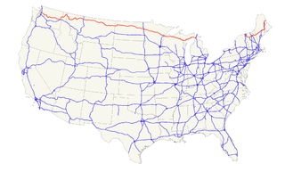
U.S. Route 2 or U.S. Highway 2 (US 2) is an east–west U.S. Highway spanning 2,571 miles (4,138 km) across the northern continental United States. US 2 consists of two segments connected by various roadways in southern Canada. Unlike some routes, which are disconnected into segments because of encroaching Interstate Highways, the two portions of US 2 were designed to be separate in the original 1926 highway plan.
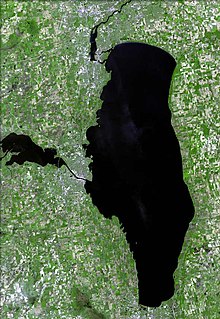
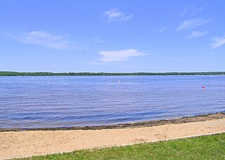
Lake Winnebago is a shallow freshwater lake in the north central United States, located in east central Wisconsin. At 137,700 acres it is the largest lake entirely within the state, covering an area of about 30 miles by 10 miles, with 88 miles of shoreline, an average depth of 15.5 feet, and a maximum depth of 21 feet.. It has many shallow reefs along the west shore, and a drop-off type shoreline on the east. There are several islands along the west shore.

Houghton Lake is a large lake in Roscommon County, Michigan. The unincorporated community of Prudenville is at the southeastern end of the lake, while the unincorporated communities of Houghton Lake and Houghton Lake Heights are on the southwest and west shores. It is the largest inland lake in the state of Michigan, and one of the largest natural inland lakes in the United States. The lake is approximately 10 miles (16 km) north to south, and about 5 1⁄2 miles (8.9 km) at it widest point. Houghton Lake has c. 30 miles (48 km) of total shoreline and its waters cover 20,044 acres (81.12 km2). It is an extremely popular resort and fishing area year round. Houghton Lake is the site of Tip-Up-Town USA, a large ice fishing and winter sports festival with several events on the frozen waters of the lake itself. Houghton Lake is named after the first state geologist, Douglass Houghton who explored the area. Houghton County, in the Upper Peninsula of Michigan is also named after Douglass Houghton. The name of the lake is pronounced by Michigan citizens as "HOTE'n" (/ˈhoʊʔn̩/).
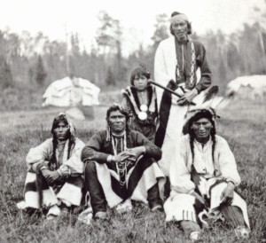
The Bad River Lapointe Band of the Lake Superior Tribe of Chippewa Indians are a federally recognized tribe of Ojibwe people. The Bad River Reservation is located on the south shore of Lake Superior and has a land area of 156,000 acres in northern Wisconsin straddling Ashland and Iron counties. The tribe has approximately 7,000 members, of whom about 1,800 lived on the reservation during the 2000 census.
Sardis Lake is a 98,520-acre (398.7 km2) reservoir on the Little Tallahatchie River in Lafayette, Panola, and Marshall counties, Mississippi. Sardis Lake is impounded by Sardis Dam, located nine miles (14 km) southeast of the town of Sardis. It is approximately an hour drive from Memphis, Tennessee. The dam is 15,300 feet (4,700 m) long, has an average height of 97 feet (30 m), and a maximum height of 117 feet (36 m).
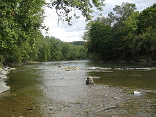
Fishing Creek is a 29.98-mile (48.25 km) long tributary of the Susquehanna River in Columbia County, Pennsylvania, in the United States. It joins the Susquehanna River near the census-designated place of Rupert and the town of Bloomsburg. The watershed has an area of 385 square miles (1,000 km2).
Lake Noquebay is a large freshwater lake in northeastern Wisconsin.

Lake Minocqua is a lake in northern Oneida County, Wisconsin. It is 1360 acres (5.5 km²) in area, with an average depth of 23 feet (7 m) and a maximum depth of 60 feet (18.3 m).

Mirror Lake State Park is a 2,179-acre (882 ha) Wisconsin state park in the Wisconsin Dells region. The process of establishing the park began in 1962 and the park officially opened on August 19, 1966. It contains Mirror Lake, a narrow reservoir with steep sandstone sides up to 50 feet (15 m) tall. The lake has a surface area of 137 acres (55 ha) and an average depth of 10 to 14 feet. Recessed out of the wind, the water of Mirror Lake is usually calm and often as glassy-smooth as a mirror, hence the name. Situated in a major tourist area, the state park has an extensive campground and other visitor amenities. Also located within the park is the Seth Peterson Cottage, a Frank Lloyd Wright-designed building available for public rental.

Sleepy Creek Wildlife Management Area is located in Morgan and Berkeley Counties in West Virginia's Eastern Panhandle. It encompasses 22,928 acres (92.79 km2), mostly covered with mixed oak and pine forest, although about 3,500 acres (14 km2) are covered with mixed hardwoods. The 205-acre (83 ha) Sleepy Creek Lake is located entirely within the WMA.

Neptune Lake is a shallow mesotrophic rural lake in Oneida County in northern Wisconsin in the United States, near the intersection of U.S. Route 45 and U.S. Route 8, about 5 miles (8.0 km) north of Pelican Lake and 1 mile (1.6 km) northwest of the small settlement of Monico. Two smaller lakes, Mars Lake and Venus Lake, are nearby.

Venus Lake is a small mesotrophic rural lake in Oneida County in northern Wisconsin in the United States, at the intersection of U.S. Route 45 and U.S. Route 8, about 4 miles (6.4 km) north of Pelican Lake and adjacent to the small settlement of Monico. The slightly smaller Mars Lake and the somewhat larger Neptune Lake are nearby, to the northwest.
Siskiwit Lake is a small eutrophic lake on the Bayfield Peninsula in Bayfield County in northern Wisconsin in the United States. The lake is located about 4.5 miles (7.2 km) south of Siskiwit Bay, an arm of Lake Superior, and about 2 miles (3.2 km) north of the northern boundary of Chequamegon National Forest. Duluth-Superior is about 48 miles (77 km) to the west. Parts of the small town of Bell border the lake, and there are several houses and vacation cabins on the lake, most on the north shore. The nearest major road, Wisconsin Highway 13, is about 3.5 miles (5.6 km) to the north, and the nearest large town, Washburn, is about 14 miles (23 km) to the southeast, down County Highway C.

Floras Lake is a natural 236-acre (96 ha) body of water on the southern Oregon Coast of the United States. Fed by four small tributaries from a basin of about 10 square miles (26 km2) in Curry County, it lies about 10 miles (16 km) north of Port Orford and 2 miles (3 km) west of U.S. Route 101. It was probably named for Fred Flora, a 19th-century settler and miner who lived nearby.


