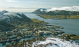
Herøy is a municipality in Møre og Romsdal county, Norway. It is part of the Sunnmøre region. The administrative centre is the town of Fosnavåg on the island of Bergsøya. The industrial area of Eggesbønes is located south of Fosnavåg on the same island. The Runde Environmental Centre is located in the northern part of the municipality on Runde island. Other population centres in Herøy include the villages of Leikong, Kvalsund, or Moltustranda.

Herøy is a municipality in Nordland county, Norway. It is part of the Helgeland traditional region. The administrative centre of the municipality is the village of Silvalen. The municipality is located about 15 kilometres (9.3 mi) west of the town of Sandnessjøen.
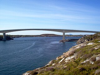
The Hoholmen Bridge is a cantilever bridge in the municipality of Herøy in Nordland county, Norway. Together with the Åkviksundet Bridge, it forms the road connection between the island municipalities of Herøy and Dønna. It is located about 5 kilometres (3.1 mi) north of the village of Herøyholmen, between the small islands of Hoholmen and Kjeøya. The bridge is 316 metres (1,037 ft) long, and the main span is 120 metres (390 ft).

The Kalvøyrevet Bridge is a cantilever bridge in the municipality of Herøy in Nordland county, Norway. The concrete bridge is 298 metres (978 ft) long, and the main span is 95 metres (312 ft). The bridge connects the small islands of Kalvøya and Hestøya and it was built as a part of Norwegian County Road 166 which connects the larger islands of Indre Øksningan and Ytre Øksningan with the rest of Herøy Municipality.

The Åkviksundet Bridge is a box girder bridge that crosses the Åkviksundet strait between the islands of Dønna and Staulen in Nordland county, Norway. Together with the Hoholmen Bridge, it forms the road connection between the municipalities of Herøy and Dønna. The bridge is 285 metres (935 ft) long, the longest of the three spans is 135 metres (443 ft), and the maximum clearance to the sea is 24.2 metres (79 ft). Jan-Eirik Nilsskog was the main engineer that built the bridge. The Åkviksundet Bridge was opened by King Harald V on 19 June 1999.

The Eiksund Bridge is a cantilever bridge in Ulstein Municipality in the Sunnmøre region of Møre og Romsdal county, Norway. The bridge is connected to the Eiksund Tunnel as part of the Eiksund Sambandet which joins several islands in the municipalities of Ulstein, Herøy, Sande, and Hareid to the mainland, without the use of ferries.

Leinøy or Leinøya is an island in the municipality of Herøy in Møre og Romsdal county, Norway. Its original name was Bølandet, but Leinøy is now the common name. The island is located east of the municipal center of Fosnavåg. The island is connected to other islands via a network of bridges. The Remøy Bridge connects it to the island Remøya, the Herøy Bridge connects it to Nautøya and Gurskøya, and a small bridge connects to the island of Bergsøya.

Bergsøy or Bergsøya is an island in the municipality of Herøy in Møre og Romsdal county, Norway. The island is the location of the municipal center of Fosnavåg as well as the Eggesbønes industrial area. The island is connected to other islands via a network of bridges. The Nerlandsøy Bridge connects it to the island Nerlandsøya and a small road bridge connects it to Leinøya. The Flåvær islands lie to the south. The highest point on the island is Igesundshetta which is 216 metres (709 ft) above sea level. The island has an area of 7.6 square kilometres (2.9 sq mi).
Kvalsund is a village in the municipality of Herøy in Møre og Romsdal county, Norway. It is located on the island of Nerlandsøya. Kvalsund is a fishing port with a sizable deep-water harbor, marina and waterfront protected by breakwaters. Kvalsund is connected to the island of Bergsøya by the Nerlandsøy Bridge.

Sør-Herøy is an island in the middle of the municipality of Herøy in Nordland county, Norway. Sør-Herøy is surrounded by the following islands: Nord-Herøy, Tenna, and Indre Øksningan. To the west lies Færøysundet, named after the islet of Færøya, which is actually a peninsula connected to Sør-Herøy. To the east lies Herøysundet, which is crossed by the Herøysund Bridge and Norwegian County Road 828 to Nord-Herøy. To the south lies Tennsundet with the Tennsund Bridge and Norwegian County Road 161 to Tenna. The bridges create part of the road network connecting the municipality of Herøy to the island of Dønna, which lies to the north in the municipality of Dønna. The island has a population of 446.

Nord-Herøy is an island in the municipality of Herøy in Nordland county, Norway. With an area of 8.9 square kilometers (3.4 sq mi), it is the largest island in the municipality. The island has about 800 residents.

Indre Øksningan is an island in the municipality of Herøy in Nordland county, Norway. Together with Ytre Øksningan, it is part of the Øksningan archipelago. The island has an area of 2.3 square kilometers (0.89 sq mi) and a population of 78 (2016). It is connected to the rest of Herøy by the Kalvøyrevet Bridge and Norwegian County Road 166.

Tenna or Kinnarøya is an island in the municipality of Herøy in Nordland county, Norway. The island has an area of 3.5 square kilometers (1.4 sq mi). It is traversed by Norwegian County Road 161, which also connects it to the neighboring island of Sør-Herøy, crossing Tennsundet over the Tennsund Bridge. To the south lies Andøysundet. The Husvær islands lie to the southwest of Tenna; they are connected to Tenna by a ferry.
County Road 161 is a 6.67-kilometer (4.14 mi) road in Nordland County, Norway. It is also locally named Sør-Herøyveien. It runs from Kjerkåsen in the municipality of Herøy to the island of Tennvalen in the same municipality. The road follows the southeast coast of the island of Sør-Herøy, crosses a bridge over Tennsundet, and then continues southwest along the length of the island of Tenna, terminating at the island of Tennvalen.
County Road 828 is a 33.6-kilometer (20.9 mi) road in Nordland County, Norway. It is also locally named Hæstadveien, Seløyveien, Brunsvikveien, Nord-Herøyveien, Sør-Herøyveien, Fagervikveien, and Flostadveien.
Staulen is an island in the municipality of Herøy in Nordland county, Norway. The 2.6-square-kilometre (1.0 sq mi) island just southwest of the large island of Dønna. The settlements on the island include the villages of Nordstaulen, Sørstaulen, and Sandvikja.