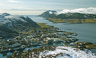
Herøy is a municipality in Møre og Romsdal county, Norway. It is part of the Sunnmøre region. The administrative centre is the town of Fosnavåg on the island of Bergsøya. The industrial area of Eggesbønes is located south of Fosnavåg on the same island. The Runde Environmental Centre is located in the northern part of the municipality on Runde island. Other population centres in Herøy include the villages of Leikong, Kvalsund, or Moltustranda.

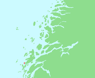
Herøy is a municipality in Nordland county, Norway. It is part of the Helgeland traditional region. The administrative centre of the municipality is the village of Silvalen. The municipality is located about 15 kilometres (9.3 mi) west of the town of Sandnessjøen.

Dønna is a municipality in Nordland county, Norway. It is part of the Helgeland region. The administrative centre of the island municipality is the village of Solfjellsjøen. Other villages include Bjørn, Dønnes, Hestad, Sandåker, and Vandve. The main island of Dønna is connected to the neighboring municipality of Herøy to the south by the Åkviksundet Bridge.
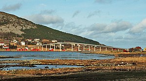
The Hoholmen Bridge is a cantilever bridge in the municipality of Herøy in Nordland county, Norway. Together with the Åkviksundet Bridge, it forms the road connection between the island municipalities of Herøy and Dønna. It is located about 5 kilometres (3.1 mi) north of the village of Herøyholmen, between the small islands of Hoholmen and Kjeøya. The bridge is 316 metres (1,037 ft) long, and the main span is 120 metres (390 ft).

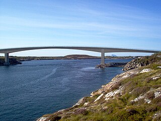
The Kalvøyrevet Bridge is a cantilever bridge in the municipality of Herøy in Nordland county, Norway. The concrete bridge is 298 metres (978 ft) long, and the main span is 95 metres (312 ft). The bridge connects the small islands of Kalvøya and Hestøya and it was built as a part of Norwegian County Road 166 which connects the larger islands of Indre Øksningan and Ytre Øksningan with the rest of Herøy Municipality.

Silvalen is the administrative centre of the municipality of Herøy in Nordland county, Norway. The village is located on two different islands, Nord-Herøy and Sør-Herøy, with the Herøysundet strait running between them. The Herøysundet Bridge crosses the strait, connecting both sides of the village. Herøy Church is located in the southern part of the village.

Bergsøy or Bergsøya is an island in the municipality of Herøy in Møre og Romsdal county, Norway. The island is the location of the municipal center of Fosnavåg as well as the Eggesbønes industrial area. The island is connected to other islands via a network of bridges. The Nerlandsøy Bridge connects it to the island Nerlandsøya and a small road bridge connects it to Leinøya. The Flåvær islands lie to the south. The highest point on the island is Igesundshetta which is 216 metres (709 ft) above sea level. The island has an area of 7.6 square kilometres (2.9 sq mi).
Eika is an island in the southern part of Ulstein Municipality in Møre og Romsdal county, Norway. It is connected to the village of Eiksund on the island of Hareidlandet by the Eiksund Bridge. Eika is connected to the mainland of Norway by the Eiksund Tunnel.

Dimnøya or Dimna is an island in Ulstein Municipality in Møre og Romsdal county, Norway. It is connected to the island of Hareidlandet to the east by a bridge. The town of Ulsteinvik lies 2 kilometres (1.2 mi) northeast of the island.
Husvær is an island group in the municipality of Herøy in Nordland county, Norway. The islands are located about 10 kilometres (6.2 mi) southwest of the municipal center of Silvalen and just southwest of the island of Tenna. The Sandværet islands lie about 5 kilometres (3.1 mi) west of Husvær. The islands have one main road connecting several of the populated islands together with a ferry link at the eastern end. The main populated islands are Husvær, Prestøya, and Brasøya. Husvær Chapel offers several worship services each year.

Herøy Church is a parish church in Herøy Municipality in Møre og Romsdal county, Norway. It is located in the town of Fosnavåg, on the island of Bergsøya. The church is part of the Herøy parish in the Søre Sunnmøre deanery in the Diocese of Møre. The concrete church was completed in 2003 to replace an older church. It was built by the architects Kino Tambs and Hans Petter Madsø from an architecture firm from Trondheim. The church was consecrated on 16 February 2003 by the Bishop Odd Bondevik. The church seats about 700 people.

Tenna or Kinnarøya is an island in the municipality of Herøy in Nordland county, Norway. The island has an area of 3.5 square kilometers (1.4 sq mi). It is traversed by Norwegian County Road 161, which also connects it to the neighboring island of Sør-Herøy, crossing Tennsundet over the Tennsund Bridge. To the south lies Andøysundet. The Husvær islands lie to the southwest of Tenna; they are connected to Tenna by a ferry.
Staulen is an island in the municipality of Herøy in Nordland county, Norway. The 2.6-square-kilometre (1.0 sq mi) island just southwest of the large island of Dønna. The settlements on the island include the villages of Nordstaulen, Sørstaulen, and Sandvikja.

Dønna is the largest island in Dønna Municipality in Nordland county, Norway. The 138-square-kilometre (53 sq mi) island lies off the west coast of the mainland of Helgeland, Norway. The islands of Løkta and Tomma lie northeast of the island, the islands of Vandve and Åsvær lie to the west, and the islands of Herøy and Alsta lie to the south.