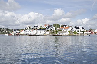
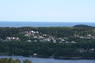
Lyngør is a village area on a group of small islands in the municipality of Tvedestrand in Aust-Agder county, off the southeast coast of Norway. The village is about 12 kilometres (7.5 mi) southeast of the town of Tvedestrand and also about 12 kilometres (7.5 mi) southwest of the town of Risør. The village actually is located on several islands located very close together and separated by small straits that are less than 100 metres (330 ft) wide. The village is located on the islands of Holmen, Odden, Lyngøya, Steinsøya, and Askerøya. The Lyngør Lighthouse lies at the northeast edge of the village area.

Dypvåg is a former municipality in Aust-Agder county, Norway. The 15-square-kilometre (5.8 sq mi) municipality existed from 1838 until its dissolution in 1960 when it was merged into the present-day municipality of Tvedestrand. The small municipality included the coastal area about 8 kilometres (5.0 mi) east of the town of Tvedestrand and several islands located just offshore. The administrative centre was the village of Dypvåg where the Dypvåg Church is located.

Kilsund is a village in Arendal municipality in Aust-Agder county, Norway. The village is located on the island of Tverrdalsøya, although the village has grown over the bridge onto the nearby island of Flostaøya a short distance to the south. The village lies about 6.5 kilometres (4.0 mi) northeast of the village of Strengereid, about 10 kilometres (6.2 mi) northeast of the village of Eydehavn, about 16 kilometres (9.9 mi) northeast of the town of Arendal, and about 8 kilometres (5.0 mi) south of the town of Tvedestrand. Kilsund has two small villages located just to the north and east: Staubø and Holmsund.
Vegår is a lake in the municipality of Vegårshei in Aust-Agder county, Norway. The 17.7-square-kilometre (6.8 sq mi) lake is located about 3 kilometres (1.9 mi) north of the municipal center of Myra and about 12 kilometres (7.5 mi) east of the village of Åmli in the neighboring municipality of Åmli.

Strengereid is a village in the municipality of Arendal in Aust-Agder county, Norway. It is located along the Norwegian County Road 410, about 3 kilometres (1.9 mi) northeast of the village of Eydehavn and just west of the island of Flostaøya. The village of Sagene lies about 2 kilometres (1.2 mi) to the northwest.
Kilen is a village in Tvedestrand municipality in Aust-Agder county, Norway. The village is located on the island Sandøya, midway between the popular tourist destinations of Kilsund and Lyngør. The village is about 11 kilometres (6.8 mi) southeast of the town of Tvedestrand on the mainland and about 3 kilometres (1.9 mi) southwest of the village of Klåholmen on the other end of the island. The village is only accessible by boat.
Klåholmen is a village in Tvedestrand municipality in Aust-Agder county, Norway. The village is located on the island of Sandøya, midway between the popular tourist destinations of Kilsund and Lyngør. The village is located about 12 kilometres (7.5 mi) southeast of the town of Tvedestrand on the mainland and about 2.5 kilometres (1.6 mi) northeast of the village of Kilen on the other end of the island.
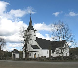
Holt is a former municipality in Aust-Agder county, Norway. The 176-square-kilometre (68 sq mi) municipality existed from 1838 until its dissolution in 1960 when it was merged into the present-day municipality of Tvedestrand. The administrative centre of Holt was located just south of the village of Fiane where Holt Church is located.
Fiane is a village in Tvedestrand municipality in Aust-Agder county, Norway. The village is located at the intersection of the European route E18 highway and the Norwegian County Road 415. Fiane is about 4 kilometres (2.5 mi) west of the town of Tvedestrand and about 2.5 kilometres (1.6 mi) southeast of the village of Nesgrenda. The historic Holt Church lies just south of Fiane, and this was the administrative centre of the old municipality of Holt which existed from 1838 until 1960.
Gjeving is a village in Tvedestrand municipality in Aust-Agder county, Norway. The village is located along the Skagerrak coast, just off Norwegian County Road 411, about 15 kilometres (9.3 mi) east of the town of Tvedestrand and about 5 kilometres (3.1 mi) east of the village of Dypvåg. The island village of Lyngør lies just offshore to the south of Gjeving.
Grønland is a village in Tvedestrand municipality in Aust-Agder county, Norway. The village is located along the Norwegian County Road 411 on the eastern shore of the Tvedestrandfjorden, about 4 kilometres (2.5 mi) southeast of the town of Tvedestrand and immediately west of the village of Sagesund.
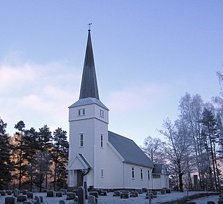
Laget is a village in Tvedestrand municipality in Aust-Agder county, Norway. The village is located at the inner end of the Sandnesfjorden, along the Norwegian County Road 411. Laget sits about 12 kilometres (7.5 mi) northeast of the town of Tvedestrand and about 10 kilometres (6.2 mi) southwest of the town of Risør. Laget Church is located in the village.
Sandnes is a village in Risør municipality in Aust-Agder county, Norway. The village is located along the southern shore of the Sandnesfjorden, about 3 kilometres (1.9 mi) west of the village of Fie, about 4 kilometres (2.5 mi) north of the village of Nipe, and about 6 kilometres (3.7 mi) east of the village of Laget in Tvedestrand municipality.

Songe is a village in Tvedestrand municipality in Aust-Agder county, Norway. The village is located along the European route E18, about 10 kilometres (6.2 mi) northeast of the town of Tvedestrand and about 5 kilometres (3.1 mi) south of the village of Akland.
Østerå is a village in Tvedestrand municipality in Aust-Agder county, Norway. The village is located along the Norwegian County Road 411 on the shores of the Tvedestrandfjorden, just east of the town of Tvedestrand and about 3 kilometres (1.9 mi) north of the villages of Grønland and Sagesund.

Østre Agder is a district or region in Aust-Agder county in southern Norway. The district covers the eastern, coastal areas of the county including the eight municipalities of Arendal, Tvedestrand, Risør, Grimstad, Gjerstad, Vegårshei, Åmli, and Froland. The city of Arendal is the largest city in the region. Other cities in the district include Tvedestrand, Grimstad, and Risør. This region is bounded by Telemark county to the north, by the Setesdal region to the northwest, and by the Kristiansand Region to the southwest.

Åmli is the administrative centre of Åmli municipality in Aust-Agder county, Norway. The village is located along the Norwegian National Road 41 and the river Nidelva, about 30 kilometres (19 mi) northwest of the town of Tvedestrand via the Norwegian County Road 415. The village of Nelaug lies about 15 kilometres (9.3 mi) to the southeast and the village of Dølemo lies about 10 kilometres (6.2 mi) to the southwest. The 0.8-square-kilometre (200-acre) village has a population (2017) of 682 which gives the village a population density of 853 inhabitants per square kilometre (2,210/sq mi).

Tvedestrand is a town and the administrative centre of Tvedestrand municipality in Aust-Agder county, Norway. The town is located at the northern end of the Tvedestrandfjorden at the intersection of the Norwegian County Road 411 and Norwegian County Road 410. The 1.93-square-kilometre (480-acre) town has a population (2017) of 2,503 which gives the town a population density of 1,297 inhabitants per square kilometre (3,360/sq mi). The Tvedestrand Church is located in the central part of the town.


