Neuburg Forest

Last updated
Neuburg Forest
Neuburger Wald.JPG
View of the Neuburg Forest from the Platte (499 m). Behind: the mountains of the Bavarian Forest.
Highest point
Peak Platte
Elevation 499 m (1,637 ft)
Dimensions
Length16 km (9.9 mi)
Area186 km2 (72 sq mi)
Naming
Native nameNeuburger Wald
Geography
Statewest and south of Passau
Range coordinates 48°33′10″N13°20′48″E / 48.55278°N 13.34667°E / 48.55278; 13.34667
Parent range Bavarian Forest
Geology
Type of rock granite, gneiss

The Neuburg Forest (German : Neuburger Wald) is a largely forested hill ridge and natural region in Lower Bavaria in the county of Passau and the borough of Passau. It is named after the village of Neuburg am Inn.

Contents

Geography

The Neuburg Forest is actually a range of foothills of the Bavarian Forest on the far side of the Danube and thus forms a perimeter zone of the Bohemian Massif. It lies south of the Danube and extends for almost 30 kilometres from the lower Vils valley near Vilshofen to the lower Inn valley near Passau, and in the southeast to Neuburg am Inn. In the north lie the steep slopes of the Löwenwand near Seestetten (southern right bank of the Danube). The average width of the hill range is just under seven kilometres. The Neuburg Forest covers an area of 186 square kilometres. [1] On Austrian territory east of the Inn, the Sauwald is its continuation. Taking that into account, the Danube has cut its way through the foothills of the Bavarian Forest for a total length of 70 km.

The Neuburg Forest is divided into three main regions: [2] in a narrower sense, only the eastern third of this area is called the Neuburg Forest, with an area of about 60 km2. [3] The central part of the natural region is called Hochbuchet, while the western part, west of the Laufenbach, between Hochbuchet and Vils valley, has no special name. Also the Alkofen Heights [4] left of the Vils are still counted as part of the natural region of the Neuburg Forest.

Most of the Neuburg Forest is located in the municipalities of Fürstenzell and Neuburg am Inn (from which the forest derives its name), as well as in the southern Passau districts of Heining. (where the Löwenwand is found), Haidenhof Nord and Haidenhof Süd. Its northwestern part west of the Lauterbach extends into the territory of the borough of Vilshofen (near Seestetten: Seestettner Holz with the 390-metre-high Hirschenberg).

The forested hill range has an average height of 400 to 475 metres, reaching its highest point at 499 metres above sea level at the summit of the Platte, [5] a flat kuppe near the village of Altenmarkt in the municipality of Fürstenzell at 48°33′10″N13°20′48″E / 48.55278°N 13.34667°E / 48.55278; 13.34667 (Platte) . On the Platte is a water tower. The second highest point is only slightly lower at 498 metres; it is located in the Hochgasse woods on the county road, the Kreisstraße PA11 near the hamlet of Haunreut, in Fürstenzell, at 48°33′07″N13°18′55″E / 48.55194°N 13.31528°E / 48.55194; 13.31528 (Platte) . [2]

The Neuburg Forest is composed of granite and gneisses. Especially on its northern and southwestern slopes, it is embedded in thick Pliocene and Pleistocene gravels.

Related Research Articles

Passau is a Landkreis (district) in the southeast of Bavaria. It encloses the city of Passau geographically from two sides. Neighboring districts are Rottal-Inn, Deggendorf, Freyung-Grafenau. To the south it borders Austria.

<span class="mw-page-title-main">Bavarian Forest</span> Region in Bavaria, Germany

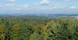
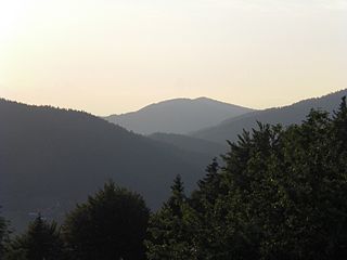
The Bavarian Forest is a wooded, low-mountain region in Bavaria, Germany that is about 100 kilometres long. It runs along the Czech border and is continued on the Czech side by the Bohemian Forest. Most of the Bavarian Forest lies within the province of Lower Bavaria, but the northern part lies within Upper Palatinate. In the south it reaches the border with Upper Austria.
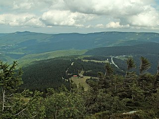
Deggendorf is a Landkreis (district) in Bavaria, Germany. It is bordered by the districts of Regen, Freyung-Grafenau, Passau, Rottal-Inn, Dingolfing-Landau and Straubing-Bogen.
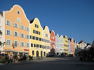
<span class="mw-page-title-main">Bundesautobahn 3</span> Autobahn in Germany

Bundesautobahn 3 is an autobahn in Germany running from the Germany-Netherlands border near Wesel in the northwest to the Germany-Austria border near Passau.

<span class="mw-page-title-main">Aldersbach</span> Municipality in Bavaria, Germany

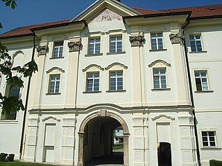
Aldersbach is a municipality in the district of Passau in Bavaria in Germany. The former Cistercian Aldersbach Abbey, of which the Baroque church remains, is located in the village. There is also a brewery with museum. Aldersbach has around 4,500 inhabitants.

<span class="mw-page-title-main">Schärding</span> Place in Upper Austria, Austria

Schärding is a town in the northern Austrian state of Upper Austria, the capital of the district of the same name, and a major port on the Inn River. Historically, it was owned by the Wittelsbach family, which is reflected in the town's architecture.

<span class="mw-page-title-main">Zenting</span> Municipality in Bavaria, Germany

Zenting is a municipality in the district of Freyung-Grafenau in Bavaria in Germany.

<span class="mw-page-title-main">Neuburg am Inn</span> Municipality in Bavaria, Germany

Neuburg am Inn is a municipality in the district of Passau in Bavaria in Germany.

<span class="mw-page-title-main">Bavarian Forest Railway</span>

The Bavarian Forest Railway links the heart of the Bavarian Forest around Regen and Zwiesel to Plattling and the Danube valley on one side, and the Czech Republic through Bayerisch Eisenstein on the other. In the Danube valley it forms a junction with the Nuremberg–Regensburg–Passau long-distance railway and, to the south, regional lines to Landshut and Munich.

<span class="mw-page-title-main">Danube</span> Second-longest river in Europe

The Danube is the second-longest river in Europe, after the Volga in Russia. It flows through much of Central and Southeastern Europe, from the Black Forest into the Black Sea. A large and historically important river, it was once a frontier of the Roman Empire and today connects ten European countries, running through their territories or being a border. Originating in Germany, the Danube flows southeast for 2,850 km (1,770 mi), passing through or bordering Austria, Slovakia, Hungary, Croatia, Serbia, Romania, Bulgaria, Moldova, and Ukraine. Among the many cities on the river are four national capitals: Vienna, Bratislava, Budapest, and Belgrade. Its drainage basin amounts to 817 000 km² and extends into nine more countries.

<span class="mw-page-title-main">Lower Bavarian Upland</span>

The Lower Bavarian Upland, Lower Bavarian Hill Country or Lower Bavarian Hills, are part of the tertiary Hügelland or hill country south of the River Danube and cover much of the land within the Bavarian province of Lower Bavaria in southern Germany. To the north it is bordered by the Gäuboden region and the Bavarian Forest; to the south by Upper Bavaria, to the east by the Lower Inn Valley and to the west by the Franconian Jura. In the western part of the Lower Bavarian Hills lies the Hallertau, the world's largest hop-growing region. It belongs to two of officially defined natural regions in Germany: the eponymous Lower Bavarian hills and the Isar-Inn Gravel Beds (Isar-Inn-Schotterplatten) and is sub-divided into the Danube-Isar Hills (Donau-Isar-Hügelland) and the Isar-Inn Upland (Isar-Inn-Hügelland) with the River Isar as the boundary. The hills continue over the border into Austria as the Upper Austrian Hills.

<span class="mw-page-title-main">Battle of Ampfing (1800)</span> A battle during the french revolutionary wars

At the Battle of Ampfing on 1 December 1800, Paul Grenier's two divisions of the First French Republic opposed the Austrian army southwest of the town of Ampfing during the French Revolutionary Wars. The Austrians, under the leadership of Archduke John of Austria, forced their enemies to retreat, though they sustained greater losses than the French. Ampfing is located 63 kilometers east of Munich and 8 km (5.0 mi) west of Mühldorf am Inn.

<span class="mw-page-title-main">Dreisesselberg (Bavarian Forest)</span> Mountain in Germany

The Dreisesselberg is a mountain in Bavaria, Germany, in the Bavarian Forest that is 1,333 metres high.

<i>Schachten</i>

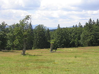
Schachten (singul.) are ancient areas of pasture in the Bavarian Forest in Germany, some of which are still used today.

<span class="mw-page-title-main">Pfahl (Bavarian Forest)</span>

The Pfahl is a 150-kilometre-long quartz vein that runs through the northeastern Bavarian Forest in Germany. From a geomorphological point of view, it represents a residual ridge that has been formed by weathering and erosion over millions of years.

<span class="mw-page-title-main">Anterior Bavarian Forest</span>

The Anterior Bavarian Forest, also variously called the Vorderer Forest, Vorderer Wald or Danube Hills, is part of the Bavarian Forest, a low mountain range in Germany.

<span class="mw-page-title-main">Kunisch Mountains</span>

The Kunisch Mountains is a range that includes part of the Bavarian Forest and the central Bohemian Forest, with its main chain between the Osser and the Zwercheck close to Upper Palatinate. From a geological perspective the Kunisch Mountains occupy a special position, because they are made of mica schist instead of the gneisses and granites that are common elsewhere in the Bavarian Forest. It has good farming soils and heavy precipitation which often falls as snow and ice in winter.

<span class="mw-page-title-main">Oberkreuzberg</span> Village of Spiegelau in Bavaria, Germany

Oberkreuzberg is a village in the municipality of Spiegelau in the Lower Bavarian district of Freyung-Grafenau in Germany. Until 1978 it was an independent municipality.

<span class="mw-page-title-main">Regen Depression</span>

The Regen Depression is a wide river valley in the Bavarian Forest along the River Regen.

<span class="mw-page-title-main">House of Poschinger</span> Bavarian noble family

The House of Poschinger is an ancient Bavarian noble family. Its origin date back to the year 1140. The family received the rank of Knights of the Holy Roman Empire. The Frauenau branch rose to the rank of Barons (Freiherr) in the Kingdom of Bavaria and held a hereditary seat in the House of Councillors.

References

  1. Bundesamt für Naturschutz: landscape fact file no. 40802 – Neuburger Wald [ permanent dead link ]
  2. 1 2 Felix Mader: Die Kunstdenkmäler von Bayern. Bezirksamt Passau. Oldenbourg, 1920, page 2 , p. 2, at Google Books
  3. Ulrich Pietrusky, Donatus Moosauer, Günther Michler: Niederbayern – im Fluge neu entdeckt. Eine Landeskunde in 103 farbigen Luftaufnahmen, Verlag Morsak Grafenau, 2. Aufl. 1982, ISBN   3-87553-135-3, p. 36: "The Neuburg Forest covers an area of about 6000 ha, of which, 100 years ago, one third was farmland."
  4. Ulrich Pietrusky, Donatus Moosauer: Der Bayerische Wald – im Fluge neu entdeckt. Eine Landeskunde mit 116 farbigen und sechs schwarz-weißen Luftaufnahmen, Verlag Morsak Grafenau, 1985, ISBN   3-87553-228-7, p. 274: "Gneiss and granite of the Alkofen Heights rarely outcrop and are covered by tertiary sediments and loess loam."
  5. Fritsch hiking map, 8th edition: "Bavarian Forest" with entries for the Bavarian Forest Nature and National Park, scale 1:100,000.

Literature