State Route 401 is a state highway in Pershing County, Nevada. The route, known as Rye Patch Road, serves the Rye Patch State Recreation Area.

State Route 206 is a state highway in Douglas County, Nevada, United States. It runs northwest from State Route 88 near the California state line along Foothill Road to Genoa, and then turns east on Genoa Lane to end at U.S. Route 395.
State Route 264 is a 33.67-mile (54.19 km) state highway in Esmeralda County, Nevada, United States. It connects California State Route 266 to U.S. Route 6 via the town of Dyer, Nevada. The majority of the route is known as Fish Lake Valley Road, with the northern portion referred to as the Dicalite Cutoff. A majority of the route was originally designated State Route 3A.
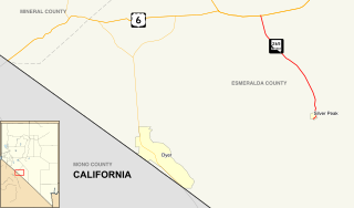
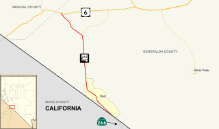
State Route 265 is a 20.5-mile (33.0 km) state highway in Esmeralda County, Nevada, United States. Referred to as Silver Peak Road, it connects the community of Silver Peak to U.S. Route 6 and U.S. Route 95. The route formerly existed as State Route 47.
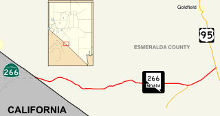
State Route 266 is a 40.338-mile (64.918 km) state highway in Esmeralda County, Nevada, United States. It connects the routing of California State Route 266 east to U.S. Route 95 via the town of Lida. Lida Road previously carried the southern end of State Route 3.
State Route 289 (SR 289) is a 1.637-mile (2.634 km) state highway in southern Humboldt County, Nevada, United States. The route serves the city of Winnemucca and the route's western end runs concurrent with Interstate 80 Business (I‑80 Bus.).
State Route 290 is a state highway in Humboldt County, Nevada. It serves to connect U.S. Route 95 to the community of Paradise Valley. The road was originally established as State Route 8B by the early 1930s.
State Route 293 is a state highway in Humboldt County, Nevada. It connects the Kings River Valley to U.S. Route 95 at the town of Orovada.
State Route 306 is a 30.631-mile (49.296 km) state highway in Lander and Eureka counties in northern Nevada, United States. It connects the mining area of Gold Acres in Lander County to Interstate 80 (I-80) at the Beowawe Interchange near Beowawe in Eureka County via Crescent Valley. The road has been a state highway since the 1920s, having been established as part of a much longer State Route 21 by 1929.

State Route 360 is a 23.245-mile-long (37.409 km) state highway in the southern portion of Mineral County, Nevada, United States. The route connects the former town of Basalt to the rest of Mineral County. A road has been in the place of SR 360 since 1919, and became State Route 10 by 1929.
State Route 374 is a state highway in Nye County, Nevada, United States. It serves as Nevada's gateway to Death Valley National Park, connecting the park to Beatty. The highway was known as State Route 58 prior to 1976.
State Route 376 is a 100-mile (160 km) state highway in Nye and Lander counties in central Nevada, United States. It connects U.S. Route 6 near Tonopah north to U.S. Route 50 near Austin. The Tonopah–Austin Road existed as early as 1919, and was designated the southernmost segment of State Route 8A before being renumbered to SR 376 in 1976.
State Route 400 is a state highway in central Pershing County, Nevada. It connects the rural town of Unionville to Mill City. The route originally extended further south under its prior designation as State Route 50.

State Route 860 is a state highway in southern Pershing County, Nevada. It runs 1.9 miles (3.1 km) from a cattle guard at Derby Field to a frontage road along Interstate 80. Between its two termini, SR 860 intersects with the southern terminus of SR 397.
State Route 398 is a state highway in Pershing County, Nevada serving the city of Lovelock. Part of the highway is former State Route 66.
State Route 726 is a 1.866-mile-long (3.003 km) state highway in Churchill County, Nevada running through a rural area north of Fallon.
State Route 427 is a 4.7-mile-long (7.6 km) state highway in the U.S. state of Nevada. It connects the community of Wadsworth in eastern Washoe County to the city of Fernley in western Lyon County. SR 427 comprises the former routing of U.S. Route 40 through the towns it serves. SR 427 also provides an eastern link to Pyramid Lake via a junction with State Route 447 in Wadsworth.
State Route 396 is a state highway in Pershing County, Nevada serving the city of Lovelock. The highway forms a portion of Interstate 80 Business within the city of Lovelock, and previously carried the alignment of former U.S. Route 40 and U.S. Route 95.
State Route 794 (SR 794) is a 2.439-mile (3.925 km)state highway in Humboldt County, Nevada, United States. The highway primarily serves as a connector road east of Winnemucca and, for all but the very east end of the route, SR 794 is concurrent with Interstate 80 Business as it runs along East Winnemucca Boulevard.
State Route 720 is a 3.248-mile-long (5.227 km) state highway in Churchill County, Nevada, south of Fallon. It serves Naval Air Station Fallon.


