Nevada State Route 396

Last updated
Nevada 396.svg
State Route 396
Cornell Avenue, Upper Valley Road
Nevada State Route 396
SR 396 highlighted in red
Route information
Maintained by NDOT
Length7.701 mi [1]  (12.394 km)
Existed1976–present
Major junctions
South endI-80.svg I-80 in Lovelock
North endI-80.svg I-80 north of Lovelock
Highway system
  • Highways in Nevada
US 395.svg US 395 Nevada 397.svg SR 397

State Route 396 (SR 396) is a state highway in Pershing County, Nevada serving the city of Lovelock. The highway forms a portion of Interstate 80 Business within the city of Lovelock, and previously carried the alignment of former U.S. Route 40 and U.S. Route 95.

Contents

Route description

View along SR 396 near the north edge of Lovelock looking northbound 2015-10-29 07 18 07 View north along Nevada State Route 396 (Cornell Avenue) in Lovelock, Nevada.jpg
View along SR 396 near the north edge of Lovelock looking northbound
SR 396 in downtown Lovelock 2015-04-18 11 38 25 View southwest along Cornell Avenue (Nevada State Route 396) near Main Street (Nevada State Route 398) in Lovelock, Nevada.jpg
SR 396 in downtown Lovelock

SR 396 begins at the West Lovelock interchange with Interstate 80 and U.S. Route 95. The route follows Cornell Avenue north into the center of the town. The highway crosses Main Street (SR 398) and continues along Cornell Avenue to its end at a five-point intersection with 14th Street, Airport Road (SR 856) and Upper Valley Road near the Lovelock city limits. Here, State Route 396 turns to follow Upper Valley Road. [2]

As the route heads northeast out of Lovelock, the surroundings become more rural in nature with open farmland on both sides of the highway. The highway also parallels the Union Pacific railroad tracks for some distance. [2] Eventually, SR 396 turns east to intersect I-80 again at the Coal Canyon interchange, where the route terminates. [1]

The Cornell Avenue portion of State Route 396 also carries a portion of Lovelock's Interstate 80 Business Loop. The business route diverges from SR 396 at 14th Street, following Airport Road back to I-80.

History

Nevada 1.svg
US 40.svg
SR 396 originated as part of State Route 1, which later became US 40.

SR 396 was originally part of State Route 1 (SR 1). [1] That route, designated with the passage of Nevada's first highway law in 1917, created a highway route across northern Nevada from California to Utah which passed through Lovelock. [3] With the adoption of the U.S. Highway System in 1926,[ citation needed ] US 40 was eventually added concurrently with SR 1. [1] [4]

With the advent of the Interstate Highway system, Interstate 80 (I-80) gradually replaced US 40 across northern Nevada and was removed from Lovelock by 1976. [5] Also around this time, the Nevada Department of Transportation was beginning to renumber its highways, eliminating the State Route 1 designation and redesignating the Lovelock portion on Cornell Avenue and Upper Valley Road as State Route 396. [6] Even though the cross-state designations of US 40 and SR 1 had been eliminated by the mid-1970s, construction of the Interstate 80 freeway in Lovelock was not started until 1981, so through traffic continued to use SR 396 in the city. [7]

Major intersections

The entire route is in Pershing County.

Locationmi [8] kmDestinationsNotes
Lovelock 0.000.00I-80.svgUS 95.svg I-80 west / US 95 south Fernley Southern terminus; southern end of I-80 Bus. concurrency
Nevada 398.svg SR 398 (Main Street)
Business Loop 80.svg I-80 BL east (Airport Road/SR 856)Northern end of I-80 Bus. concurrency
Nevada 398.svg SR 398 (Fairview Road)
7.7012.39I-80.svgUS 95.svg I-80  / US 95  Winnemucca, Fernley Northern terminus
1.000 mi = 1.609 km; 1.000 km = 0.621 mi

See also

Related Research Articles

State Route 401 is a state highway in Pershing County, Nevada. The route, known as Rye Patch Road, serves the Rye Patch State Recreation Area.

Interstate 80 (I-80) traverses the northern portion of the U.S. state of Nevada. The freeway serves the Reno–Sparks metropolitan area and passes through the towns of Fernley, Lovelock, Winnemucca, Battle Mountain, Carlin, Elko, Wells and West Wendover on its way through the state.

State Route 221 is a state highway in Elko County, Nevada. The route, concurrent with Interstate 80 Business follows Chestnut Street in the city of Carlin. The highway was once part of the former route of State Route 1 and former U.S. Route 40 (US 40).

State Route 223 is a state highway in Elko County, Nevada, United States. Co-signed with Interstate 80 Business, it serves the town of Wells.

Nevada State Route 278

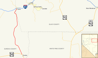
State Route 278 is a state highway in Nevada. It runs from U.S. Route 50 near Eureka north to Interstate 80 (I-80) in Carlin.

State Route 294 is a 7.973-mile (12.831 km) state highway in southeastern Humboldt County, Nevada, United States, that runs along the northernmost part of Grass Valley Road and connects Winnemucca with the Grass Valley area south of the town.

State Route 304 is a state highway in Lander County, Nevada, United States. The road is the main street through the town of Battle Mountain, and is also designated Interstate 80 Business. The highway was part of SR 1 and U.S. Route 40 prior to the mid-1970s.

State Route 400 is a state highway in central Pershing County, Nevada. It connects the rural town of Unionville to Mill City. The route originally extended further south under its prior designation as State Route 50.

Nevada State Route 397 Highway in Nevada

State Route 397 is a state highway in the U.S. state of Nevada. It runs from State Route 860 near Derby Field east on Westergard Road and north on Meridian Road into Lovelock. After passing under Interstate 80/U.S. Route 95, it turns northeast on Amherst Avenue and ends at State Route 398, two blocks southeast of State Route 396.

Nevada State Route 447 Highway in Nevada

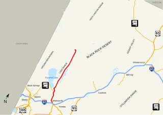
State Route 447 is a state highway in the U.S. state of Nevada. The highway is almost entirely within Washoe County but does for a brief time enter Pershing County, Nevada. The highway connects the town of Gerlach to the remainder of the state via Wadsworth. Though passing through extremely remote and desolate areas of Nevada, the highway has recently gained fame as the primary route to access the Black Rock Desert, the site of the annual Burning Man festival. The state maintained portion ends at Gerlach; however the highway continues as Washoe County Route 447 from Gerlach north to the California state line near Cedarville.

Nevada State Route 860 Highway in Nevada

State Route 860 is a state highway in southern Pershing County, Nevada. It runs 1.9 miles (3.1 km) from a cattle guard at Derby Field to a frontage road along Interstate 80. Between its two termini, SR 860 intersects with the southern terminus of SR 397.

State Route 856 is a state highway in Pershing County, Nevada serving Lovelock. The western portion of the route is also signed as Interstate 80 Business.

Nevada State Route 854 Highway in Nevada

State Route 854 is a state highway in Pershing County, Nevada serving the vicinity of Lovelock. The route comprised a portion of former State Route 48.

State Route 398 is a state highway in Pershing County, Nevada serving the city of Lovelock. Part of the highway is former State Route 66.

State Route 535 (SR 535) is the Nevada Department of Transportation (NDOT) designation for two discontinuous sections of Idaho Street just west of and within the small city of Elko in the northeastern part of the U.S. state of Nevada. Both segments are also signed as Interstate 80 Business, which is also signed along the city-maintained segment of Idaho Street between the two NDOT segments as well as the city-maintained segment of Idaho Street east of the final eastern terminus all the way to East Jennings Way, from which it connects to the Elko East exit on Interstate 80. Most of Interstate 80 Business in Elko, including both segments of SR 535, were formerly designated U.S. Route 40.

U.S. Route 95 in Nevada Section of U.S. Highway in Nevada, United States

U.S. Route 95 is a major U.S. highway traversing the U.S. state of Nevada from north to south directly through Las Vegas and providing connections to both Carson City and Reno. US 95 is cosigned with Interstate 80 for 95 miles (153 km) between a junction in Trinity and Winnemucca before heading north into Oregon at McDermitt. At 646 miles, it is the longest highway in Nevada.

State Route 399 is an 18.18-mile (29.26 km) state highway in Pershing County, Nevada. It connects Eagle-Picher Mine to Lovelock, the nearest town.

Interstate 80 Business (BL-80) is an interstate business route in Pershing County, Nevada. Serving the city of Lovelock along Cornell Avenue, BL-80 is also cosigned along portions of two other state highways through the city:

State Route 659 is a state highway in Washoe County, Nevada. The route follows McCarran Boulevard, an arterial ring road serving the cities of Reno and Sparks. The route provides access to many businesses and residential areas in the Truckee Meadows.

References

Route map:

KML file (edithelp)
    KML is not from Wikidata
    1. 1 2 3 4 Nevada Department of Transportation (January 2017). "State Maintained Highways of Nevada: Descriptions and Maps" . Retrieved 2017-04-10.
    2. 1 2 Lovelock Area (PDF) (Map). Nevada Department of Transportation. 2011. Archived from the original (PDF) on January 18, 2017. Retrieved January 25, 2016.
    3. Statutes of the State of Nevada Passed at the Twenty-Eighth Session of the Legislature. Carson City, Nevada: State Printing Office. 1917. p. 312. Retrieved December 14, 2009.
    4. "General Highway Map – Pershing County, Nevada (sheet 1 of 2)" (PDF). Nevada Department of Highways. 1937. Archived from the original (PDF) on February 15, 2017. Retrieved January 25, 2016.
    5. 1976-77 Official Highway Map of Nevada (Map). Nevada State Highway Department. 1976. Archived from the original on February 9, 2011. Retrieved December 14, 2009.
    6. Nevada State Maintained Highways: Descriptions, Index and Maps. Nevada Department of Transportation. January 2001. p. 113.
    7. "NDOT News Spring 2006" (PDF). Nevada Department of Transportation. 2006. Archived from the original (PDF) on March 4, 2016. Retrieved January 25, 2016.
    8. "Maps of Milepost Location on Nevada's Federal and State Highway System by County" (PDF). Nevada Department of Transportation. May 2008. Archived from the original (PDF) on May 20, 2009. Retrieved August 9, 2009.