Neve Glacier

Last updated
Neve Glacier
Neve Glacier North Cascades USGS.jpg
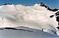
View of Neve Glacier at right from the northeast as seen in 1971. The smaller Colonial Glacier is at left.
USA Washington relief location map.jpg
Red pog.svg
Neve Glacier
Location in Washington
TypeAlpine glacier
Location Skagit and Whatcom County, Washington, U.S.
Coordinates 48°38′46″N121°08′28″W / 48.64611°N 121.14111°W / 48.64611; -121.14111 Coordinates: 48°38′46″N121°08′28″W / 48.64611°N 121.14111°W / 48.64611; -121.14111 [1]
Length1.80 mi (2.90 km)
TerminusBarren rock
StatusRetreating

Neve Glacier is in North Cascades National Park in the U.S. state of Washington and is on the north slopes of Snowfield Peak. Neve Glacier flows generally north and splits in two with two terminal tongues, one flowing to the northwest which is known as Ladder Creek Glacier and the other descending a total of more than 1.8 mi (2.9 km) to the east. Ladder Creek Glacier descends from 7,800 to 6,000 ft (2,400 to 1,800 m), while the east tongue also originates from the same altitude and descends to 5,600 ft (1,700 m). [2] Between 1850 and 2006, Neve Glacier is estimated to have retreated more than 1,000 m (3,300 ft). [3]

Contents

See also


Notes

  1. "Neve Glacier". Geographic Names Information System . United States Geological Survey . Retrieved March 17, 2013.
  2. Diablo Dam, WA (Map). TopoQuest (United States Geological Survey Maps). Retrieved March 17, 2013.
  3. Pelto, Mauri. "North Cascade Glacier Retreat". Nichols College. Archived from the original on October 22, 2012. Retrieved March 17, 2013.

Related Research Articles

Park Glacier glacier in the United States

Park Glacier is located on the northeast slopes of Mount Baker in the North Cascades of the U.S. state of Washington. Park Glacier descends to the Park Cliffs along its eastern margin while the northern tongue of the glacier descends to nearly 4,500 ft (1,400 m) and is below Park Cliffs and Lava Divide. In the middle of its course, Park Glacier is connected to Rainbow Glacier to the north and Boulder Glacier to the south.

Chocolate Glacier glacier in the United States

Chocolate Glacier is located on east slopes of Glacier Peak in the U.S. state of Washington. The glacier descends from 10,400 ft (3,200 m) to 5,900 ft (1,800 m) and is partially connected to Cool Glacier which lies to its south just below the summit of Glacier Peak. As is true with all the glaciers found on Glacier Peak, Chocolate Glacier is retreating. Chocolate Glacier retreated approximately 1,380 m (4,530 ft) between 1906 and 1946, however during a cooler and wetter period from about 1950 to 1979, the glacier advanced 450 m (1,480 ft). Chocolate Glacier has resumed retreating since and has given back 350 m (1,150 ft), nearing its previously recorded minimal length. The current terminus at 1800 m is still the lowest of the east side glacier. Chocolate Glacier remains heavily crevassed and active to 1900 m. The lowest 300 m of the glacier are stagnant.

Eldorado Glacier glacier in the United States

Eldorado Glacier is on the south slopes of Eldorado Peak, North Cascades National Park, in the U.S. state of Washington. The glacier is approximately .85 mi (1.37 km) in length, 1.2 mi (1.9 km) in width at its terminus and descends from 8,400 to 7,000 ft. Eldorado Glacier is connected to Inspiration Glacier on its upper slopes. Glacial melt waters from Eldorado Glacier flow south over Roush Creek Falls, which at 2,000 ft (610 m), is one of the tallest waterfalls in Washington.

McAllister Glacier glacier in the United States

McAllister Glacier is in a large cirque to the north and east of Dorado Needle, North Cascades National Park, in the U.S. state of Washington. The glacier is approximately 1.85 mi (2.98 km) in length, 1.5 mi (2.4 km) in width at its terminus and descends from 8,000 to 4,500 ft, where it terminates near a proglacial lake. McAllister Glacier is nearly connected to Inspiration Glacier to the south and the two glaciers are separated by the arête known as Tepeh Towers. Klawatti Peak and an arete extending north from that peak separate McAllister Glacier from the Klawatti Glacier to the east. Satellite imagery indicates that between 1998 and 2006, McAllister Glacier retreated more than 500 ft (150 m).

North Klawatti Glacier glacier in the United States

North Klawatti Glacier lies in a cirque to the east of Austera Peak, North Cascades National Park, in the U.S. state of Washington. The glacier is approximately 1.4 mi (2.3 km) in length, .40 mi (0.64 km) in width at its widest and descends from 7,800 to 6,000 ft, where it terminates above Klawatti Lake. An arête divides North Klawatti Glacier from Klawatti Glacier to the south. The North Klawatti Glacier was one of four glaciers selected for glacier mass balance research.

Chickamin Glacier (Washington) glacier in the United States

Chickamin Glacier is in the U.S. state of Washington. Chickamin Glacier is in Wenatchee National Forest and flows north from Dome Peak and Sinister Peak, descending from nearly 8,600 to 5,600 ft. Chickamin Glacier is separated from Dome Glacier to the south and Dana Glacier to the west by arêtes. The relatively narrow tongue of the 2-mile (3.2 km) wide glacier retreated 800 ft (240 m) between 1998 and 2006.

Borealis Glacier glacier in the United States

Borealis Glacier is in North Cascades National Park in the U.S. state of Washington and is on the north slopes of Primus Peak. Borealis Glacier flows generally northeast for a distance of approximately .70 mi (1.13 km). Borealis Glacier descends from nearly 7,200 to 6,000 ft, but is split into an upper and lower sections. The upper section is as much as .90 mi (1.45 km) wide, but ends abruptly in an icefall along some cliffs. The lower section has been retreating significantly, and between 1990 and 2009 lost almost 250 m (820 ft) in length, creating a proglacial lake at the terminus.

Colonial Glacier glacier in the United States

Colonial Glacier is in North Cascades National Park in the U.S. state of Washington and is immediately northwest of Neve Peak. Colonial Glacier flows generally north, descending from 6,800 to 6,000 ft. Between 1950 and 2006, Colonial Glacier is estimated to have retreated more than 300 m (980 ft) and a newly formed proglacial lake filled the recently vacated former terminal moraine. The reduction in size of the glaciers of the North Cascades will reduce summertime meltwater runoff which is used to maintain a steady supply of electricity from hydroelectric power plants.

Diobsud Creek Glacier glacier in the United States

Diobsud Creek Glacier is in North Cascades National Park in the U.S. state of Washington and is on the east slopes of Bacon Peak. Diobsud Creek Glacier has a shallow gradient, descending to the east from 7,000 to 6,000 ft for a distance of nearly 1 mi (1.6 km). The ridge is an arête which separates Diobsud Creek Glacier from Green Lake Glacier to the north.

Green Lake Glacier glacier in the United States

Green Lake Glacier is in North Cascades National Park in the U.S. state of Washington and is immediately northeast of Bacon Peak. Green Lake Glacier descends from a ridge extending from the east of Bacon Peak. The glacier forms two tongues descending to the north of the ridge from 6,600 to 5,500 ft. The ridge is an arête which separates Green Lake Glacier from Diobsud Creek Glacier to the south. Meltwater from the glacier spills over Bacon Lake Falls en route to Green Lake.

Challenger Glacier (Washington) Glacier in the United States

Challenger Glacier is in North Cascades National Park in the U.S. state of Washington and is on the north slopes of Mount Challenger. Challenger Glacier descends from 8,000 to 5,000 ft. Over 2 mi (3.2 km) wide, Challenger Glacier descends along a wide terminus with heavy crevassing and numerous icefalls, with a tongue of the glacier in the north descending to a proglacial lake. The ascent up Challenger Glacier is one of the most common routes to the summit of Mount Challenger.

Crystal Glacier glacier in the United States

Crystal Glacier is in North Cascades National Park in the U.S. state of Washington, on the south slopes of Mount Shuksan. Descending 1.25 mi (2.01 km) from just east of the summit of Mount Shuksan, near its origination point, Crystal Glacier is connected to the larger Sulphide Glacier to the west. Crystal Glacier descends from 8,200 to 5,800 ft, and is also connected to East Nooksack Glacier as well as Hanging Glacier near it uppermost margins. Both Crystal and Sulphide Glaciers have a series of 300-to-1,000-foot high cascades which are collectively referred to as Sulphide Basin Falls. Below these cascades lies Sulphide Lake, which empties over Sulphide Creek Falls, one of the highest waterfalls in North America with a nearly 2,200 ft (670 m) drop.

Sulphide Glacier glacier in Washington state, United States

Sulphide Glacier is in North Cascades National Park in the U.S. state of Washington, on the south slopes of Mount Shuksan. Descending 1.85 mi (2.98 km) from the summit tower of Mount Shuksan, it is connected to Crystal Glacier to the east. Sulphide Glacier descends from 8,600 to 5,600 ft. Sulphide Glacier is along the route taken when Mount Shuksan was first climbed in 1906. Both Sulphide and Crystal Glaciers have a series of 300-to-1,000-foot high cascades which are collectively referred to as Sulphide Basin Falls. Below these cascades lies Sulphide Lake, which empties over Sulphide Creek Falls, one of the highest waterfalls in North America with a nearly 2,200 ft (670 m) drop.

Goode Glacier glacier in the United States

Goode Glacier is in North Cascades National Park in the U.S. state of Washington, on the east slopes of Goode Mountain. Goode Glacier is a hanging glacier and is broken into several sections descending from 7,200 to 5,800 ft. Goode Glacier sits more than 2,800 ft (850 m) below the summit of Goode Mountain, the tallest peak in North Cascades National Park.

Ladder Creek Glacier glacier in the United States

Ladder Creek Glacier is in North Cascades National Park in the U.S. state of Washington and is a northwest tongue of the larger Neve Glacier. Ladder Creek Glacier added 105 m (344 ft) between 1950 and 1979, but lost 190 m (620 ft) from 1979 to 2006. Ladder Creek Glacier descends from 7,800 to 6,000 ft.

Noisy Creek Glacier glacier in the United States

Noisy Creek Glacier is in North Cascades National Park in the U.S. state of Washington, .50-mile (0.80 km) northwest of Bacon Peak. Noisy Creek Glacier has retreated and left behind a series of small proglacial lakes. Noisy Creek Glacier descends from 6,400 to 5,800 ft. A ridge separates Noisy Creek Glacier from Green Lake Glacier to the east. The National Park Service is currently studying Noisy Creek Glacier as part of their glacier monitoring project.

Watson Glacier glacier in Washington state, United States

Watson Glacier is in Snoqualmie National Forest in the U.S. state of Washington, on the north slope of Mount Watson. Watson Glacier retreated 430 ft (130 m) between 1950 and 2007 and is now only 1,150 ft (350 m) in length. Watson Glacier descends from 6,000 to 5,700 ft.

Redoubt Glacier glacier in the United States

Redoubt Glacier is in North Cascades National Park in the U.S. state of Washington, on the east slopes of Mount Redoubt. Redoubt Glacier descends from the 8,400-foot (2,600 m) point on the east slope of Mount Redoubt then has a south terminus near 7,200 ft (2,200 m). The glacier then has a shallow gradient for most of its course before descending north on a wide 1.5 mi (2.4 km) front to 6,500 ft (2,000 m). Melt from the glacier feeds into Depot Creek which flows into Chilliwack Lake. The Depot Glacier lies to the west of Redoubt Glacier.

Depot Glacier (Washington) glacier in the United States

Depot Glacier is in North Cascades National Park in the U.S. state of Washington, on the northeast slopes of Mount Redoubt. Depot Glacier descends from the 7,400 to 6,000 ft. Melt from the glacier feeds into Depot Creek which flows into Chilliwack Lake. The Redoubt Glacier lies to the east while the West Depot Glacier is separated from Depot Glacier by a ridge.

West Depot Glacier glacier in Washington state, United States

West Depot Glacier is in North Cascades National Park in the U.S. state of Washington, on the north slopes of Mount Redoubt. Depot Glacier descends from 7,400 to 5,900 ft. Melt from the glacier feeds into Depot Creek which flows into Chilliwack Lake. A ridge separates West Depot Glacier from Depot Glacier to the east.

References

The Neve Glacier, looking west, from the Pacific Crest Trail near Slate Pass Neve Glacier from PCT near Slate Pass.JPG
The Neve Glacier, looking west, from the Pacific Crest Trail near Slate Pass
Neve Glacier seen from Neve Peak Neve glacier.jpg
Neve Glacier seen from Neve Peak