New Hartley Ponds

Last updated
New Hartley Ponds
Site of Special Scientific Interest
Northumberland UK location map.svg
Red pog.svg
Location within Northumberland
Area of Search Northumberland
Grid reference NZ 305764
Coordinates 55°04′50″N1°31′22″W / 55.080602°N 1.522830°W / 55.080602; -1.522830 Coordinates: 55°04′50″N1°31′22″W / 55.080602°N 1.522830°W / 55.080602; -1.522830
InterestBiological
Area1.58 hectares (3.9 acres)
Notification 1984
Location map DEFRA MAGIC map
Natural England website

New Hartley Ponds is the name given to a Site of Special Scientific Interest (SSSI) in south-east Northumberland, England. The site comprises six seasonal ponds listed for their vegetation and newt population. [1] [2]

Site of Special Scientific Interest Conservation designation denoting a protected area in the United Kingdom

A Site of Special Scientific Interest (SSSI) in Great Britain or an Area of Special Scientific Interest (ASSI) in the Isle of Man and Northern Ireland is a conservation designation denoting a protected area in the United Kingdom and Isle of Man. SSSI/ASSIs are the basic building block of site-based nature conservation legislation and most other legal nature/geological conservation designations in the United Kingdom are based upon them, including national nature reserves, Ramsar sites, Special Protection Areas, and Special Areas of Conservation. The acronym "SSSI" is often pronounced "triple-S I".

Northumberland County of England

Northumberland is a county in North East England. The northernmost county of England, it borders Cumbria to the west, County Durham and Tyne and Wear to the south and the Scottish Borders to the north. To the east is the North Sea coastline with a 64 miles (103 km) path. The county town is Alnwick, although the County council is based in Morpeth.

Newt

A newt is a salamander in the subfamily Pleurodelinae, also called eft during its terrestrial juvenile phase. Unlike other members of the family Salamandridae, newts are semiaquatic, alternating between aquatic and terrestrial habitats over the year, sometimes even staying in the water full-time. Not all aquatic salamanders are considered newts, however. More than 100 known species of newts are found in North America, Europe, North Africa and Asia. Newts metamorphose through three distinct developmental life stages: aquatic larva, terrestrial juvenile (eft), and adult. Adult newts have lizard-like bodies and return to the water every year to breed, otherwise living in humid, cover-rich land habitats.

Contents

Location and natural features

New Hartley Ponds is situated in the north-east of England in the county of Northumberland, on the south-west fringe of the village of New Hartley. The ponds lie at 30 metres (98 ft) above sea level on flat terrain, some 2.7 kilometres (1.7 mi) inland from the North Sea. The six ponds on the 1.58 hectares (3.9 acres) site are seasonal in nature. [1] [2] [3]

North East England Place in England

North East England is one of nine official regions of England at the first level of NUTS for statistical purposes. It covers Northumberland, County Durham, Tyne and Wear, and the area of the former county of Cleveland in North Yorkshire. The region is home to three large conurbations: Teesside, Wearside, and Tyneside, the last of which is the largest of the three and the eighth most populous conurbation in the United Kingdom. There are three cities in the region: Newcastle upon Tyne, the largest, with a population of just under 280,000; Sunderland, also in the metropolitan county of Tyne and Wear; and Durham. Other large towns include Darlington, Gateshead, Hartlepool, Middlesbrough, South Shields, Stockton-on-Tees and Washington.

New Hartley village in United Kingdom

New Hartley is a small village in South East Northumberland, England, adjacent to Hartley, Seaton Delaval and Seaton Sluice. The village is just off the A190 road about 6 miles (9.7 km) north of Tynemouth and 4 miles (6.4 km) south of Blyth.

Flora and fauna

The ponds are breeding grounds for five species of amphibians; notably the great-crested newt (Triturus cristatus), a species protected in the UK under Section 5 of the Wildlife and Countryside Act 1981, which at New Hartley can number 500 individuals. Populations of up to 1000 smooth newts (Lissotriton vulgaris), and occasional palmate newts (Lissotriton helveticus) are also found. Frogs and toads, numbering approximately 150 individuals each, and also found. The ponds are also home to two species of Damselfly - the blue-tailed damselfly (Ischnura elegans) and the common darter (Sympetrum striolatum). [2]

Northern crested newt species of amphibian

The northern crested newt, also known as the great crested newt or warty newt is a newt in the family Salamandridae, found across Europe and parts of Asia.

Wildlife and Countryside Act 1981

The Wildlife and Countryside Act 1981 is an Act of Parliament in the United Kingdom implemented to comply with European Council Directive 2009/147/EC on the conservation of wild birds. In short, the act gives protection to native species, controls the release of non-native species, enhances the protection of Sites of Special Scientific Interest and builds upon the rights of way rules in the National Parks and Access to the Countryside Act 1949. The Act is split into 4 parts covering 74 sections; it also includes 17 schedules.

Smooth newt species of amphibian

The smooth newt, also known as the common newt is a species of amphibian, the most common newt of the genus Lissotriton. It is found throughout Europe, except the far north, areas of Southern France and the Iberian Peninsula.

Vegetation at the ponds includes amphibious bistort ( Polygonum amphibium ), common spike-rush ( Eleocharis palustris ), water horsetail ( Equisetum fluviatile ) and water crowfoot ( Ranunculus aquatilis ). [2]

<i>Persicaria amphibia</i> species of plant

Persicaria amphibia is a species of flowering plant in the knotweed family known by several common names, including longroot smartweed, water knotweed, water smartweed, and amphibious bistort. It is native to much of North America, Asia, Europe, and parts of Africa, and it is known elsewhere as an introduced species and sometimes a noxious weed.

<i>Eleocharis palustris</i> species of plant

Eleocharis palustris, the common spike-rush, creeping spike-rush or marsh spike-rush, is a species of mat-forming perennial flowering plants in the sedge family Cyperaceae. It grows in wetlands in Europe, North Africa, northern and central Asia and North America. Eleocharis palustris is not easily distinguished from other closely related species and is extremely variable worldwide itself. The species epithet palustris is Latin for "of the marsh" and indicates its common habitat.

<i>Equisetum fluviatile</i> species of plant

Equisetum fluviatile, the water horsetail or swamp horsetail, is a vascular plant that commonly grows in dense colonies along freshwater shorelines or in shallow water in ponds, swamps, ditches, and other sluggish or still waters with mud bottoms. It is a perennial herbaceous species, growing 30–100 cm tall with erect dark green stems 2–8 mm in diameter, smooth, with about 10–30 fine ridges. At each joint, the stem has a whorl of tiny, black-tipped scale leaves 5–10 mm long. Many, but not all, stems also have whorls of short ascending and spreading branches 1–5 cm long, with the longest branches on the lower middle of the stem. The side branches are slender, dark green, and have 1–8 nodes with a whorl of five scale leaves at each node. The water horsetail has the largest central hollow of the horsetails, with 80% of the stem diameter typically being hollow.

The condition of New Hartley Ponds was judged to be favourable, and described as 'outstanding' in 2010, with concerns expressed as to newts getting trapped in gully pots on the New Hartley Road. [3]

See also

Related Research Articles

Fontburn reservoir in the United Kingdom

Fontburn is a drinking water reservoir situated 10 miles (16 km) northwest of the market town of Morpeth in Northumberland, England.

Machynys Ponds

Machynys Ponds is a Site of Special Scientific Interest (SSSI) in Carmarthenshire, Wales, designated in 1993 for its botanical features.

Allen Confluence Gravels

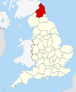
The Allen Confluence Gravels is the name given to a Site of Special Scientific Interest (SSSI) in Northumberland, England. The site, listed since 1968, has an 'outstanding assemblage of river margin invertebrates.'

Alnmouth Saltmarsh and Dunes

Alnmouth Saltmarsh and Dunes is a Site of Special Scientific Interest (SSSI) in Northumberland, England. It is the largest saltflat on the north-east coast, located on the south bank of the River Aln estuary, and notable for the varied plant community found on the interface between the saltflats and the dunes. It overlaps with and forms part of the much larger Northumberland Shore SSSI.

Arcot Hall Grasslands and Ponds

Arcot Hall Grasslands and Ponds is the name given to a Site of Special Scientific Interest (SSSI) near Cramlington in Northumberland, England, notable as the largest lowland species-rich grassland in North East England. The site is composed of grassland, heath, ponds, and associated damp habitats now rare in Northumberland.

Aules Hill Meadows

Aules Hill Meadows is the name given to a Site of Special Scientific Interest (SSSI) in Northumberland, England. The site, listed since 1992, is a set of four traditionally managed northern hay meadows, now rare in Northumberland.

Bamburgh Coast and Hills

Bamburgh Coast and Hills is the name given to a Site of Special Scientific Interest (SSSI) on the coast of north Northumberland, England. The site is one of the longest-standing SSSIs in England, having been listed since 1954, and displays the interaction of a fluid magma rock, now known as the Whin Sill, interacting with older sedimentary rock. Coastal erosion at the site enables sections of the geological strata to be seen. In turn, the soil associated with the Whin Sill gives rise to a distinct pattern of vegetation which on its own merits is at this site found notable.

Barelees Pond

Barelees Pond is the name given to a Site of Special Scientific Interest (SSSI) in north Northumberland, England. The site is a kettle hole, a deep pond formed in the void remaining after a submerged glacial calf block melted. Barelees Pond is illustrative of vegetative habitat evolution as peat sediment gradually fills the pond.

Campfield Kettle Hole

Campfield Kettle Hole is the name given to a Site of Special Scientific Interest (SSSI) in north Northumberland, England. The site is thought to be the remains of a kettle hole, a pond formed in the void remaining after a submerged glacial calf block melted. In contemporary times Campfield Kettle Hole is a mix of bog and pond.

Bradford Kames

Bradford Kames is the name given to a Site of Special Scientific Interest (SSSI) in north Northumberland, England. The site is an esker, a ridge of glacial till deposited in the Pleistocene epoch.

Barrow Burn Meadows Site of Special Scientific Interest in England

Barrow Burn Meadows is the name given to a Site of Special Scientific Interest (SSSI) in north Northumberland, England. The site is a species-rich hay meadow of a sort now rare in Northumberland.

Barrow Meadow

Barrow Meadow is the name given to a Site of Special Scientific Interest (SSSI) in north Northumberland, England. The site is a species-rich hay meadow of a sort now rare in Northumberland.

Bavington Crags

Bavington Crags is the name given to a Site of Special Scientific Interest (SSSI) in north Northumberland, England. The site is an outcropping of the Whin Sill which gives rise to a distinctive flora particular to the thin soil conditions on this bedrock.

Beltingham River Shingle

Beltingham River Shingle is the name given to a Site of Special Scientific Interest (SSSI) in Northumberland in the north-east of England, notable for an unusual community of flora tolerant to the high levels of naturally occurring heavy metals in the sediment of a section of the River South Tyne.

Bewick and Beanley Moors

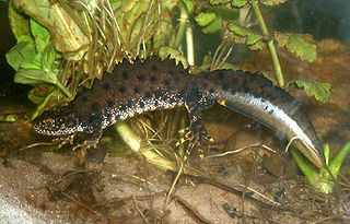
Bewick and Beanley Moors is the name given to a Site of Special Scientific Interest (SSSI) in north Northumberland, in the north-east of England. The moors are asserted to be of national importance by Natural England for the extent, quality and diversity of upland types including heaths, fens, wet grassland, flushes, mires and blanket bogs, together creating an extensive mosaic habitat supporting an exceptional community of amphibians. The moors are important, too, for their relict juniper woodland and scrub.

Billsmoor Park and Grasslees Wood

Billsmoor Park and Grasslees Wood is the name given to a Site of Special Scientific Interest (SSSI) in Northumberland, North East England, designated in 1954. Billsmoor Park is an extensive alder woodland of a sort increasingly uncommon in the county; the much smaller Grasslees Wood is an oak woodland.

Brada Hill

Brada Hill is a small hill escarpment near the coast of north Northumberland in North East England, designated as a Site of Special Scientific Interest (SSSI). The 2.4 hectares site is an outcropping of a local stone group, the Whin Sill, on which grows a range of flora representative of the thin, drought-prone soil conditions and influenced by the underlying geology.

Brunton Bank Quarry

Brunton Bank Quarry is a disused quarry now designated as a Site of Special Scientific Interest (SSSI) in north Northumberland, North East England. The quarry exposes a base layer of the Namurian Great Limestone stratigraphic unit, including the Chaetetes Band, the fossilised fauna within which is of current geological interest.

Longhoughton Quarry Site of Special Scientific Interest (SSSI) in north Northumberland

Longhoughton Quarry is a Site of Special Scientific Interest (SSSI) in north Northumberland in North East England. The site is a now disused quarry which yielded whinstone, a hard dark rock associated in Northumberland with the Whin Sill.

Fallowlees Flush Site of Special Scientific Interest (SSSI) in mid-Northumberland, England

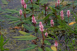
Fallowlees Flush is the name given to a Site of Special Scientific Interest (SSSI) in mid-Northumberland, England. The steeply sloping site has calcium-rich springs supporting vegetation rare in the county.

References

  1. 1 2 "MAGIC Map Application - New Hartley Ponds". DEFRA MAGIC Map. DEFRA.
  2. 1 2 3 4 "New Hartley Ponds SSSI Citation" (PDF). Natural England.
  3. 1 2 "Condition of SSSI Units for Site New Hartley Ponds". Natural England. 26 June 2012.