The Rio Grande in the United States or the Río Bravo del Norte in Mexico is one of the principal rivers in the southwestern United States and in northern Mexico. The length of the Rio Grande is 1,896 miles (3,051 km), making it the 4th longest river in North America by main stem. It originates in south-central Colorado, in the United States, and flows to the Gulf of Mexico. The Rio Grande drainage basin (watershed) has an area of 182,200 square miles (472,000 km2); however, the endorheic basins that are adjacent to and within the greater drainage basin of the Rio Grande increase the total drainage-basin area to 336,000 square miles (870,000 km2).

The Compromise of 1850 was a package of five separate bills passed by the United States Congress in September 1850 that temporarily defused tensions between slave and free states in the years leading up to the American Civil War. Designed by Whig senator Henry Clay and Democratic senator Stephen A. Douglas, with the support of President Millard Fillmore, the compromise centered on how to handle slavery in recently acquired territories from the Mexican–American War (1846–48).

The Treaty of Guadalupe Hidalgo officially ended the Mexican–American War (1846–1848). It was signed on 2 February 1848 in the town of Guadalupe Hidalgo.

The Adams–Onís Treaty of 1819, also known as the Transcontinental Treaty, the Spanish Cession, the Florida Purchase Treaty, or the Florida Treaty, was a treaty between the United States and Spain in 1819 that ceded Florida to the U.S. and defined the boundary between the U.S. and Mexico. It settled a standing border dispute between the two countries and was considered a triumph of American diplomacy. It came during the successful Latin American wars of independence against Spain.

The Territory of New Mexico was an organized incorporated territory of the United States from September 9, 1850, until January 6, 1912. It was created from the U.S. provisional government of New Mexico, as a result of Nuevo México becoming part of the American frontier after the Treaty of Guadalupe Hidalgo. It existed with varying boundaries until the territory was admitted to the Union as the U.S. state of New Mexico. This jurisdiction was an organized, incorporated territory of the US for nearly 62 years, the longest period of any territory in the contiguous United States.

The Mexican Cession is the region in the modern-day southwestern United States that Mexico originally controlled, then ceded to the United States in the Treaty of Guadalupe Hidalgo in 1848 after the Mexican–American War. This region had not been part of the areas east of the Rio Grande that had been claimed by the Republic of Texas, though the Texas annexation resolution two years earlier had not specified the southern and western boundary of the new state of Texas. At roughly 529,000 square miles (1,370,000 km2), the Mexican Cession was the third-largest acquisition of territory in U.S. history, surpassed only by the 827,000-square-mile (2,140,000 km2) Louisiana Purchase and the 586,000-square-mile (1,520,000 km2) Alaska Purchase.
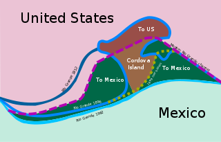
The Chamizal dispute was a border conflict over around 600 acres on the Mexico–United States border between El Paso, Texas, and Ciudad Juárez, Chihuahua. It was caused by a shift in the Rio Grande, as a survey presented in 1852 marked differences between the bed of the Rio Grande and the present channel of the river. Tensions over the territory during the historic Taft–Díaz summit almost resulted in the attempted assassination of both presidents on October 16, 1909.

The International Boundary and Water Commission is an international body created by the United States and Mexico in 1889 to apply the rules for determining the location of their international boundary when meandering rivers transferred tracts of land from one bank to the other, as established under the Convention of November 12, 1884.
The Rio Grande has changed course several times in recorded history, leading to a number of border disputes and uncertainties, both international and between individual U.S. states:
Río Rico is a village located along the Rio Grande in the Mexican state of Tamaulipas. It includes a portion of the Horcón Tract, a narrow 461-acre (1.87 km2) piece of land that was part of the United States until 1977.
The Boundary Treaty of 1970 is a treaty between the United States and Mexico that settled all outstanding boundary disputes and uncertainties related to the Rio Grande border between them.

The Mexico–United States border is an international border separating Mexico and the United States, extending from the Pacific Ocean in the west to the Gulf of Mexico in the east. The border traverses a variety of terrains, ranging from urban areas to deserts. The Mexico–U.S. border is the most frequently crossed border in the world with approximately 350 million documented crossings annually. It is the tenth-longest border between two countries in the world.
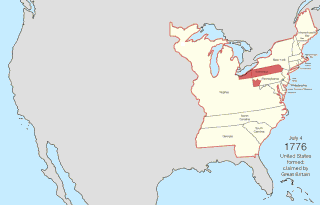
The United States of America was formed after thirteen British colonies in North America declared independence from the British Empire on July 4, 1776. In the Lee Resolution, passed by the Second Continental Congress two days prior, the colonies resolved that they were free and independent states. The union was formalized in the Articles of Confederation, which came into force on March 1, 1781, after being ratified by all 13 states. Their independence was recognized by Great Britain in the Treaty of Paris of 1783, which concluded the American Revolutionary War. This effectively doubled the size of the colonies, now able to stretch west past the Proclamation Line to the Mississippi River. This land was organized into territories and then states, though there remained some conflict with the sea-to-sea grants claimed by some of the original colonies. In time, these grants were ceded to the federal government.
Florida v. Georgia, 58 U.S. 478 (1854), was a United States Supreme Court case invoking the Court's original jurisdiction to determine boundary disputes between states. In this case the boundary dispute was between the State of Florida and the State of Georgia.
Andrew Belcher Gray was an American surveyor.
The Country Club Area is a suburb of El Paso, Texas. It was the object of a lengthy border dispute between Texas and New Mexico.
The Banco Convention of 1905, between the United States and Mexico, was negotiated and signed in 1905 and ratified by both nations in 1907. It resulted in 247 exchanges of bancos between the two nations from 1910 to 1976. Most of them were in the Lower Rio Grande Valley, the Presidio Valley and the El Paso-Juarez Valley. In 1927, the convention was applied to the short international border on the Colorado River.
Texas v. New Mexico and Colorado, 583 U.S. ___ (2018), was a Supreme Court case argued and decided during the 2017 term of the Supreme Court of the United States. The case involved an interstate dispute regarding New Mexico's compliance with the Rio Grande Compact of 1938, an agreement which established a plan for equitable apportionment of the water in the Rio Grande Basin among the states of Colorado, New Mexico, and Texas. The Court considered the question of whether the U.S. federal government had a legal right to join litigation against New Mexico; the Court ruled that the federal government was within its rights when it did so.