
Daventry is a market town and civil parish in the West Northamptonshire unitary authority in Northamptonshire, England, close to the border with Warwickshire. At the 2011 Census Daventry had a population of 25,026, making it the sixth largest town in Northamptonshire.

The Daventry District was from 1974 to 2021 a local government district in western Northamptonshire, England. The district was named after its main town of Daventry where the council was based.

Badby is a village and a rural parish of about 2,020 acres (820 ha) in West Northamptonshire, England.

Staverton is a village and civil parish in the south-west of Northamptonshire, England. It is 2.3 miles west of Daventry, 7.9 miles east of Southam and 15.3 miles east of Leamington Spa. It straddles the A425 road from Daventry to Leamington. The Jurassic Way long distance footpath between Banbury and Stamford passes through the village.
Newnham is a village in West Northamptonshire in England. The village is 2 miles (3.2 km) south of Daventry, 3 miles (4.8 km) west from Weedon Bec, 6 miles (9.7 km) west of junction 16 of the M1 motorway and 11 miles (18 km) west of Northampton. The A45 road runs a mile northwest of the village. The nearest railway station is at Long Buckby, 8 miles (13 km) northeast.

Hellidon is a village and civil parish about 5 miles (8 km) south-west of Daventry in Northamptonshire, England. The parish area is about 1,600 acres (650 ha). It lies 520 feet (160 m) – 590 feet (180 m) above sea level on the north face of an ironstone ridge, its highest point, 670 feet (200 m) at Windmill Hill, being 0.5 miles (800 m) south-east of the village. The Leam and tributaries rise in the parish. The 2011 Census gave a population of 256, estimated at 286 in 2019. The long-distance Jurassic Way footpath linking Banbury, Oxfordshire, and Stamford, Lincolnshire, passes through. The origin of the name is unclear. "Holy Valley", "Haegla's Valley" and "Unstable valley" have been suggested, with the Old English "dun", meaning hill.

Borough Hill is a hill to the east of the town of Daventry in the English county of Northamptonshire. It is over 200 metres (660 ft) above sea level and dominates the surrounding area.

In the field of road transport, an interchange or a grade-separated junction is a road junction that uses grade separations to allow for the movement of traffic between two or more roadways or highways, using a system of interconnecting roadways to permit traffic on at least one of the routes to pass through the junction without interruption from crossing traffic streams. It differs from a standard intersection, where roads cross at grade. Interchanges are almost always used when at least one road is a controlled-access highway or a limited-access divided highway (expressway), though they are sometimes used at junctions between surface streets.
Stowe Nine Churches is a civil parish incorporating the settlements of Church Stowe and Upper Stowe in the English county of Northamptonshire. The population of the civil parish at the 2011 census was 259.
The Clee Hills are a range of hills in Shropshire, England near Ludlow, consisting of Brown Clee Hill 1,772 feet (540 m), the highest peak in Shropshire, and Titterstone Clee Hill 1,749 feet (533 m). They are both in the Shropshire Hills Area of Outstanding Natural Beauty.

The A563 is the designation for the ring road of Leicester, England. It forms a near-complete circuit except for a gap of around 2.2 miles (3.5 km) in the east of the city. An indirect route linking the gap involves the (A47) A6030, and A6. The A563 was formerly referred to as the Outer Ring.
Highgate is a small village located within the Walsall Ring Road. The village was constructed in the Victorian era for the wealthy, and has developed a reputation as one of the most expensive neighbourhoods in Walsall for house prices.

The Bumble Hole line was a short railway located in Central England. It opened in 1878 to give Dudley a direct railway link with Old Hill, over a distance of three miles. It was used as a connection between Dudley town and Snow Hill, and was dual track all of the way, to allow its inclusion into a mainline route. As with most lines of this nature, patronage was extremely poor and passengers would often find themselves alone on the single car Class 122 DMU that operated the service in later years.
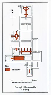
Borough Hill Roman villa is located on the north tip of Borough Hill, a prominent hill near the town of Daventry in Northamptonshire. The villa’s remains lie within the ramparts of an Iron Age fortress which covers the summit of the hill. The remains of the Roman villa were discovered in 1823 by the historian and archaeologist George Baker, who identified Borough Hill with the Benaventa of the Britons and Isannavaria of the Romans. The remains were not fully excavated until 1852 when local historian Beriah Botfield thoroughly excavated and recorded the site. Botfield employed an artist to make drawings of the site and these illustrations along with Botfield's notes, manuscripts and some of the antiquities found on the site are now kept at the British Museum.

New Mill is a Grade II* listed post mill at Cross in Hand near Heathfield, East Sussex, England. It was the last windmill working commercially by wind in Sussex, ceasing work by wind in 1969 when a stock broke.

The London Area Control Centre (LACC) is an air traffic control centre based at Swanwick near Fareham in Hampshire, southern England. It is operated by National Air Traffic Services (NATS), starting operations on 27 January 2002, and handles aircraft over much of England and Wales. The Swanwick facility replaces that of the former site at West Drayton.
The Bullo Pill Railway was an early British railway, completed in 1810 to carry coal mined in the Forest of Dean Coalfield to a port on the River Severn near Newnham, Gloucestershire. It was later converted to a broad gauge steam line by the Great Western Railway, and was closed in the 1960s.

Windmill Hill is a chalk hill running alongside the A3(M) in the East Hampshire district of Hampshire, England, overlooking Chalton to the east, and Clanfield to the west. It measures 193 metres above sea level and is named so because of Chalton Windmill which sits upon its summit. This windmill is a Grade II listed building which lay derelict until the late 1970s, when it was restored and converted into a private residence.
The Mitcheldean Road and Forest of Dean Junction Railway was an independent railway company incorporated in 1871, to provide a northerly outlet for iron ore and coal products from the Cinderford and Whimsey area in the Forest of Dean, to the Hereford, Ross and Gloucester Railway line; mineral traffic to industrial centres in South Wales and the Midlands was foreseen.

The Church of St Vincent in Newnham in Hertfordshire is a 12th-century Anglican parish church and a Grade II* listed building, having gained that status in 1968. The church is named for Saint Vincent and is under the Diocese of St Albans; it is noted for the Newnham Murals which were uncovered in 1963.
