
Nauener Platz is a Berlin U-Bahn station located on the U 9. The square that gives it its name is named after the city of Nauen.

Dziećmorowice is a village in the administrative district of Gmina Walim, within Wałbrzych County, Lower Silesian Voivodeship, in south-western Poland.

Osaka Kyoiku University is a national university with headquarters in the city of Kashiwara, Osaka Prefecture, Japan and a branch campus in Tennōji-ku in the prefectural capital city of Osaka. It was established in 1949 by the merger of two predecessor institutions. Its short name is Daikyōdai. The university specializes in educating teachers. Unique among the national universities is its five-year program of nighttime study.
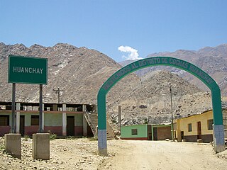
Cochas District is one of ten districts of the province Ocros in Peru.
Liszkówko is a village in the administrative district of Gmina Sadki, within Nakło County, Kuyavian-Pomeranian Voivodeship, in north-central Poland.
Ciosmy is a village in the administrative district of Gmina Biłgoraj, within Biłgoraj County, Lublin Voivodeship, in eastern Poland. It lies approximately 13 kilometres (8 mi) west of Biłgoraj and 79 km (49 mi) south of the regional capital Lublin.
Zofiówka is a village in the administrative district of Gmina Szczuczyn, within Grajewo County, Podlaskie Voivodeship, in north-eastern Poland.
Smolanka is a village in the administrative district of Gmina Sokółka, within Sokółka County, Podlaskie Voivodeship, in north-eastern Poland, close to the border with Belarus. It lies approximately 10 kilometres (6 mi) west of Sokółka and 32 km (20 mi) north-east of the regional capital Białystok.
Wólka is a settlement in the administrative district of Gmina Sidra, within Sokółka County, Podlaskie Voivodeship, in north-eastern Poland.
Głaniszew is a village in the administrative district of Gmina Warta, within Sieradz County, Łódź Voivodeship, in central Poland. It lies approximately 6 kilometres (4 mi) west of Warta, 18 km (11 mi) north-west of Sieradz, and 64 km (40 mi) west of the regional capital Łódź.
Kunówka is a village in the administrative district of Gmina Tarnawatka, within Tomaszów Lubelski County, Lublin Voivodeship, in eastern Poland.
Niesułowice is a village in the administrative district of Gmina Olkusz, within Olkusz County, Lesser Poland Voivodeship, in southern Poland. It lies approximately 10 kilometres (6 mi) south of Olkusz and 32 km (20 mi) north-west of the regional capital Kraków.
Opatkowice Cysterskie is a village in the administrative district of Gmina Imielno, within Jędrzejów County, Świętokrzyskie Voivodeship, in south-central Poland.
Dębsko-Ostoja is a village in the administrative district of Gmina Koźminek, within Kalisz County, Greater Poland Voivodeship, in west-central Poland.
Chojniczki-Wybudowanie is a settlement in the administrative district of Gmina Chojnice, within Chojnice County, Pomeranian Voivodeship, in northern Poland. It lies approximately 3 kilometres (2 mi) north of Chojnice and 101 km (63 mi) south-west of the regional capital Gdańsk.
Łyśniewo Sierakowickie is a village in the administrative district of Gmina Sierakowice, within Kartuzy County, Pomeranian Voivodeship, in northern Poland. It lies approximately 4 kilometres (2 mi) west of Sierakowice, 24 km (15 mi) west of Kartuzy, and 52 km (32 mi) west of the regional capital Gdańsk.
Jeżyce is a village in the administrative district of Gmina Darłowo, within Sławno County, West Pomeranian Voivodeship, in north-western Poland. It lies approximately 7 kilometres (4 mi) south of Darłowo, 19 km (12 mi) west of Sławno, and 159 km (99 mi) north-east of the regional capital Szczecin.

Bưng Riềng is a commune (xã) and village in Xuyên Mộc District, Bà Rịa–Vũng Tàu Province, in Vietnam.
Liivanõmme is a village in Saaremaa Parish, Saare County in western Estonia.

Liješće is a village in the municipality of Srebrenica, Bosnia and Herzegovina.


