
Menterwolde is a former municipality in the province of Groningen in the Netherlands. On January 1, 2018, Menterwolde merged with Hoogezand-Sappemeer and Slochteren, forming the municipality Midden-Groningen.

Reiderland is a former municipality in the province Groningen in the northeastern Netherlands, which was founded in 1990 during a large municipal reorganisation. The former municipalities Finsterwolde and Bad Nieuweschans were abolished and added to Beerta. In 1992, the new municipality was given its current name. In 2010 it joined in the municipality Oldambt.

Scheemda is a village with a population of 2,445 in the municipality of Oldambt in the province of Groningen in the Netherlands. Scheemda was a separate municipality until 2010, when it merged with Reiderland and Winschoten to form the municipality of Oldambt.

Bad Nieuweschans is a village in the north-eastern Netherlands on the border with Germany. It forms part of the municipality of Oldambt. Nieuweschans means "new fortification (sconce)". In 2009, the word Bad ("spa") was prefixed to the name of the village to promote it as a tourist destination.
Zoutkamp is a village in the municipality Het Hogeland which is part of the province Groningen in the Netherlands. The village started as a sconce. During the Dutch Revolt, it was the site of the Battle of Zoutkamp. Later it became a fishing village. The harbour was moved to Lauwersoog in 1969 as a result of the closure of the Lauwersmeer, and is nowadays used for recreational purposes. The economy of the village mainly depends on fishing.

Goudswaard is a village in the Dutch province of South Holland, located on the westernmost tip of the Hoeksche Waard, approximately 6 km south-west of Spijkenisse. Goudswaard was a separate municipality from 1817 until 1984, when it was merged with Nieuw-Beijerland, Zuid-Beijerland and Piershil to form the municipality of Korendijk. The built-up area of Goudswaard is 0.28 km². As of 1 January 2014, the village has 1,956 inhabitants, and contains 804 residences.

Beerta is a village and former municipality with a population of 2,205 in the municipality of Oldambt in the province of Groningen in the Netherlands. In the 20th century, Beerta was a communist stronghold. In 1933, the municipal council was dismissed by the government, and was ruled by a government commissioner until 1935. Between 1982 and 1990, Beerta was the only municipality with a communist mayor.

Bellingwolde is a village with a population of 2,655 people in the municipality Westerwolde in the Netherlands. It is situated in the southeast of the region Oldambt, in the north of the region Westerwolde, and in the east of the province Groningen, at the border with Germany.

Pieterburen is a village in the northeastern Netherlands, located in the municipality of Het Hogeland, Groningen.
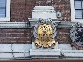
In the Netherlands, a water board, water council or water authority is a regional governing body solely charged with the management of surface water in the environment, acting independently of administrative governing bodies like provinces and municipalities. In general they're responsible for managing rivers and canals, flowing watercourses and drainage issues, water collection, preventing of flooding and erosion and take care there's enough water for citizens. Specifically they manage polder systems, water levels, water barriers and locks, enforcements, water quality and sewage treatment in their respective regions. The concept of a coordinating "High Water Authority" (Hoogheemraadschap) origins in what now is the province of South Holland in the 12th century.

't Waar is a village in the province of Groningen in the Netherlands. It is located in the municipality of Oldambt, just north of the village of Nieuw-Scheemda.

Oldambt is a municipality with a population of 38,129 in the province of Groningen in the Netherlands. It was established in 2010 by merging the municipalities of Reiderland, Scheemda, and Winschoten. It contains the city of Winschoten and these villages:

Scheemda is an unstaffed railway station in Scheemda in the Netherlands. It is located on the Harlingen–Nieuweschans railway between Zuidbroek and Winschoten in the province of Groningen.

Winschoten is an unstaffed railway station in Winschoten in the Netherlands. It is located on the Harlingen–Nieuweschans railway between Scheemda and Bad Nieuweschans in the province of Groningen.
A Tjasker is a type of small drainage windmill used in the Netherlands and Germany. There are 28 tjaskers remaining the Netherlands.

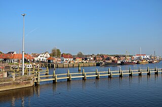
Lauwersoog is a seaside village and harbour in the province of Groningen, located in the northern part of the Netherlands. It is part of the municipality of Het Hogeland. It was established on 23 May 1969. The ferry to Schiermonnikoog departs from Lauwersoog.

Drieborg is a dike village in the Dutch province of Groningen. It is a part of the municipality of Oldambt.

Kleine Huisjes is a village in the Dutch province of Groningen. It is a part of the municipality of Het Hogeland. It is located 1.5 kilometres (0.93 mi) north-east of Kloosterburen.

Visvliet is a village in the Dutch province of Groningen. It is part of the municipality of Westerkwartier, and is located near the river Lauwers, the border between Friesland and Groningen.

Westernieland is a village in the Dutch province of Groningen. It is part of the municipality of Het Hogeland. The village is located near the Wadden Sea.


