
Ambikapur is a city and headquarters of Surguja district in the Indian state of Chhattisgarh. It is one of the oldest cities in the state, in east-central India. Ambikapur is also the divisional headquarters of Surguja Division which consists of the six districts of Surguja, Korea, Manendragarh, Balrampur, Surajpur and Jashpur.

Pilibhit district is one of the 75 districts in the state of Uttar Pradesh in India, and Pilibhit city is the district headquarters. Pilibhit district is a part of Bareilly Division. A Tiger Reserve Area was named Pilibhit Tiger Reserve in September 2008.
Umaria district is a district of Madhya Pradesh. The town of Umaria is the district headquarters. The district is part of Shahdol Division.

Murwara district popularly known as Katni district is one of the 52 districts of Madhya Pradesh state in central India. The town of Murwara (Katni) is the district headquarters. The district is part of Jabalpur Division. The district occupies an area of 4949.59 km².
Jabalpur district is a district of Madhya Pradesh state in central India. The city of Jabalpur is the administrative headquarters of the district.

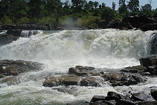
Katni officially Murwara is a city on the banks of the Katni River in Madhya Pradesh, India. It is the administrative headquarters of Katni District. It is in the Mahakoshal region of central India. The city is 90 km (56 mi) from the divisional headquarters of the region, Jabalpur.
Amlai is a census town in Shahdol district in the state of Madhya Pradesh, India.
Jaithari is a town and a tehsil in Anuppur district in the Indian state of Madhya Pradesh.
Kymore is an industrial town and a nagar panchayat in Vijayraghavgarh tehsil in Katni district in the Indian state of Madhya Pradesh. Known mainly for its cement works established in 1921 by J. K. Fisher.
Nowrozabad or Khodargama is a town and a nagar palika in Umaria district in the Indian state of Madhya Pradesh. Kendriya Vidyalaya Nowrozabad is situated in the G.M Complex Johila area. Nowrozabad is the head office of Johila area. The nearest airport is at Jabalpur in Madhya pradesh. Nowrozabad Railway Station is on the Katni - Anuppur rail route. There are many coal mines around here. National Highway 43 has its route through Nowrozabad.
Pawai is a town and a nagar panchayat in the Panna district of Madhya Pradesh state in central India. It is mostly surrounded by rocky area.
Pilkhuwa is a town and a municipal board in Hapur district in the Indian state of Uttar Pradesh. It is located 12 km from Hapur, the district headquarters. It is famous for its textile products and handloom industry.
Vijayraghavgarh is a town, tehsil headquarters, and a nagar panchayat located in Katni district in the Indian state of Madhya Pradesh. It belongs to Jabalpur division and is 34 km (21 mi) east of district headquarters Katni.
Sumerpur, also known as Bharuwa Sumerpur, is a town and a nagar panchayat in Hamirpur district, Uttar Pradesh, India.
Barhi is a town and a Nagar Parishad in Katni district in the state of Madhya Pradesh, India.

Kartarpur is a town, near the city of Jalandhar in Jalandhar district in the Indian state of Punjab and is located in the Doaba region of the state. It was founded by the fifth Guru of the Sikhs, Guru Arjan.
The Katni copper-plate of Jayanātha is an epigraphic record documenting the donation of the village of Kalabhikuṇḍaka in the time of the Uccakalpa ruler mahārāja Jayanātha. It is dated year 182 in the Gupta era.
Beohari is a major town and a nagar panchayat in Shahdol district in the state of Madhya Pradesh, India. It is 79.07 kilometres (49.13 mi) from the main district of Shahdol and 412 kilometres (256 mi) away from Bhopal, the state capital. Its geographical coordinates are 24° 3' 0" North, 81° 23' 0" East.
Raipura is a town which comes under the jurisdiction of Panna district, Madhya Pradesh, India. It is one of the nine tehsils of Panna. It is about 113 km from the district headquarters. It is surrounded by Damoh and Katni districts.
Sukhi Sewaniya is a village in the Bhopal district of Madhya Pradesh, India. It is located in the Huzur tehsil and the Phanda block. Located near the Bhopal Bypass road, it has gradually developed into a suburb of the Bhopal city.
