The Balkans, corresponding partially with the Balkan Peninsula, is a geographical area in southeastern Europe with various geographical and historical definitions. The region takes its name from the Balkan Mountains that stretch throughout the whole of Bulgaria. The Balkan Peninsula is bordered by the Adriatic Sea in the northwest, the Ionian Sea in the southwest, the Aegean Sea in the south, the Turkish straits in the east, and the Black Sea in the northeast. The northern border of the peninsula is variously defined. The highest point of the Balkans is Musala, 2,925 metres (9,596 ft), in the Rila mountain range, Bulgaria.

Croatia, officially the Republic of Croatia, is a country in Central and Southeast Europe, on the coast of the Adriatic Sea. It borders Slovenia to the northwest, Hungary to the northeast, Serbia to the east, Bosnia and Herzegovina and Montenegro to the southeast, and shares a maritime border with Italy to the west. Its capital and largest city, Zagreb, forms one of the country's primary subdivisions, with twenty counties. Other major urban centers include Split, Rijeka and Osijek. The country spans 56,594 square kilometres, and has a population of nearly 3.9 million.

The demographic characteristics of the population of Croatia are known through censuses, normally conducted in ten-year intervals and analysed by various statistical bureaus since the 1850s. The Croatian Bureau of Statistics has performed this task since the 1990s. The latest census in Croatia was performed in autumn of 2021. According to final results published on 22 September 2022 the permanent population of Croatia at the 2021 census had reached 3.87 million. The population density is 68.7 inhabitants per square kilometre, and the overall life expectancy in Croatia at birth was 78,2 years in 2018. The population rose steadily from 2.1 million in 1857 until 1991, when it peaked at 4.7 million. Since 1991, Croatia's death rate has continuously exceeded its birth rate; the natural growth rate of the population is negative. Croatia is in the fourth stage of the demographic transition. In terms of age structure, the population is dominated by the 15 to 64 year‑old segment. The median age of the population is 43.4, and the gender ratio of the total population is 0.93 males per 1 female.

Yugoslavia was a country in Southeast and Central Europe that existed from 1918 to 1992. It came into existence following World War I, under the name of the Kingdom of Serbs, Croats and Slovenes from the merger of the Kingdom of Serbia with the provisional State of Slovenes, Croats and Serbs, and constituted the first union of South Slavic peoples as a sovereign state, following centuries of foreign rule over the region under the Ottoman and Habsburg empires. Peter I of Serbia was its first sovereign. The kingdom gained international recognition on 13 July 1922 at the Conference of Ambassadors in Paris. The official name of the state was changed to Kingdom of Yugoslavia on 3 October 1929.

Dalmatia is one of the four historical regions of Croatia, alongside Central Croatia, Slavonia, and Istria, located on the east shore of the Adriatic Sea in Croatia.

Dubrovnik is a city in southern Dalmatia, Croatia, by the Adriatic Sea. It is one of the most prominent tourist destinations in the Mediterranean, a seaport and the centre of the Dubrovnik-Neretva County. Its total population is 41,562. In 1979, the city of Dubrovnik was added to the UNESCO list of World Heritage Sites in recognition of its outstanding medieval architecture and fortified old town.

Zagreb is the capital and largest city of Croatia. It is in the north of the country, along the Sava river, at the southern slopes of the Medvednica mountain. Zagreb stands near the international border between Croatia and Slovenia at an elevation of approximately 158 m (518 ft) above sea level. At the 2021 census, the city itself had a population of 767,131, while the population of Zagreb metropolitan area is 1,217,150.

The Croats or Horvati are a South Slavic ethnic group native to Croatia, Bosnia and Herzegovina and other neighboring countries in Central and Southeastern Europe who share a common Croatian ancestry, culture, history and language. They also form a sizeable minority in a number of neighboring countries, namely Slovenia, Austria, the Czech Republic, Germany, Hungary, Italy, Montenegro, Romania, Serbia and Slovakia.
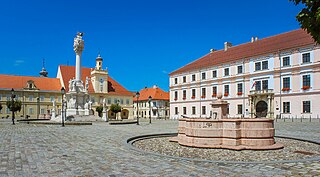
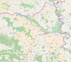
Osijek is the fourth-largest city in Croatia, with a population of 96,848 in 2021. It is the largest city and the economic and cultural centre of the eastern Croatian region of Slavonia, as well as the administrative centre of Osijek-Baranja County. Osijek is on the right bank of the Drava River, 25 km (16 mi) upstream of its confluence with the Danube, at an elevation of 94 m (308 ft).

Sisak is a city in central Croatia, spanning the confluence of the Kupa, Sava and Odra rivers, 57 km (35 mi) southeast of the Croatian capital Zagreb, and is usually considered to be where the Posavina begins, with an elevation of 99 m. The city's total population in 2021 was 40,185 of which 27,886 live in the urban settlement (naselje).

Zadar is the oldest continuously inhabited city in Croatia. It is situated on the Adriatic Sea, at the northwestern part of Ravni Kotari region. Zadar serves as the seat of Zadar County and of the wider northern Dalmatian region. The city proper covers 25 km2 (9.7 sq mi) with a population of 75,082 in 2011, making it the second-largest city of the region of Dalmatia and the fifth-largest city in the country.

Šibenik is a historic town in Croatia, located in central Dalmatia, where the river Krka flows into the Adriatic Sea. Šibenik is a political, educational, transport, industrial and tourist center of Šibenik-Knin County, and is also the third-largest town in the Dalmatian region. As of 2021, the town has 31,115 inhabitants, while the municipality has 42,599 inhabitants.
Zagreb County is a county in Northern Croatia. It surrounds, but does not contain, the nation's capital Zagreb, which is a separate territorial unit. For that reason, the county is often nicknamed "Zagreb ring". According to the 2021 census, the county has 299,985 inhabitants, most of whom live in smaller urban satellite towns.

Primorje – Gorski Kotar County is a county in western Croatia, most of it based in the historical and cultural region called Croatia proper and some of it in Istria, including the Bay of Kvarner, the surrounding Northern Croatian Littoral, and the mountainous region of Gorski Kotar. Its center is Rijeka. The county's population was 296,195 at the 2011 census.

Karlovac is a city in central Croatia. In the 2021 census, its population was 49,377.

Knin is a city in the Šibenik-Knin County of Croatia, located in the Dalmatian hinterland near the source of the river Krka, an important traffic junction on the rail and road routes between Zagreb and Split. Knin rose to prominence twice in history, as the capital of both the medieval Kingdom of Croatia and briefly of the self-proclaimed Republic of Serbian Krajina within the newly independent Republic of Croatia for the duration of Croatian War of Independence from 1991 to 1995.

Gospić is a town in Lika, Croatia. It is the seat of the Lika-Senj County.

The Croats of Bosnia and Herzegovina, often referred to as Bosnian Croats or Herzegovinian Croats, are native to Bosnia and Herzegovina and constitute the third most populous ethnic group, after Bosniaks and Serbs. They are also one of the constitutive nations of Bosnia and Herzegovina. Croats of Bosnia and Herzegovina have made significant contributions to the culture of Bosnia and Herzegovina. Most Croats declare themselves Catholics and speakers of the Croatian language.

Split, is the second-largest city of Croatia after the capital Zagreb, the largest city in Dalmatia and the largest city on the Croatian coast. It lies on the eastern shore of the Adriatic Sea and is spread over a central peninsula and its surroundings. An intraregional transport hub and popular tourist destination, the city is linked to the Adriatic islands and the Apennine Peninsula. More than 900,000 tourists visit it each year.