Mau, also now known as Maunath Bhanjan, is an industrial town and the headquarter of the Mau district. It is located in the eastern part of Uttar Pradesh, India. The town is known for its saree industry which is a traditional business and centuries old art of the people of this city; says, Pallavi Mishra.
Mubarakpur is a town and a municipal board in Azamgarh district in the Indian state of Uttar Pradesh. It is located at a distance of 13 km north-east of the district headquarters in Azamgarh.

Azamgarh is a city in the Indian state of Uttar Pradesh. It is the headquarters of Azamgarh division, which consists of Ballia, Mau and Azamgarh districts. Azamgarh is situated on the bank of Tamsa River (Tons). It is located 268 km (167 mi) east of the state capital Lucknow and 809 km from national capital, Delhi.

Azamgarh district is one of the three districts of Azamgarh division in the Indian state of Uttar Pradesh.

Baraut is a city and municipal board, near the city of Baghpat in Baghpat district, Uttar Pradesh, India.
Amilo is a census town in Azamgarh district in the state of Uttar Pradesh, India.
Bilariaganj is the second largest city and a Nagar Palika Parishad in Azamgarh division after its capital city Azamgarh in the state of Uttar Pradesh, India.
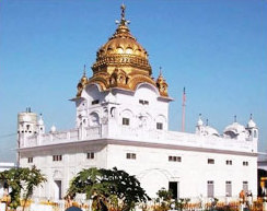
Dera Baba Nanak is a town and a municipal council in Gurdaspur district, in the state of Punjab, India. It is 36km away from Gurdaspur city, the capital of the district. Since November 2019, a corridor between India and Pakistan has been established at its shrine.
Dhanuha is a census town in Jaunpur district in the state of Uttar Pradesh, India.
Nautanwa is a town and Nagar Palika in Maharajganj district in the state of Uttar Pradesh, India. It is about 87 km from Gorakhpur, NH24 and 68 km NH730 from Maharajganj and 7 km from Sonauli Indo-Nepal Border.
Jalalpur is a town, tehsil and a municipal board in Ambedkar Nagar district in the Indian state of Uttar Pradesh, India.
Jiyanpur is a town and a nagar panchayat in Azamgarh district in the Indian state of Uttar Pradesh. It lies along State Highway 66.
Kerakat or Kirakat is a town and nagar panchayat in Jaunpur district of the Indian state of Uttar Pradesh with a population of approximately 13,500. It is situated near the Gomati River, which helps the land around the town stay very fertile. Kerakat or Kirakat forms a part of Varanasi Division. It is located 30 km east of the city of Jaunpur and 279 km from Lucknow, the capital of Uttar Pradesh.
Mehnagar is a town and a nagar panchayat in Azamgarh district in the Indian state of Uttar Pradesh.
Phulpur is a town and a nagar panchayat in Azamgarh district in the Indian state of Uttar Pradesh.
Rudauli is a town, tehsil and a municipal board in Faizabad district in the Indian state of Uttar Pradesh. Rudauli is 40 km west of the district headquarters Ayodhya.
Sarai Mir is a town and a nagar panchayat in Azamgarh district in the Indian state of Uttar Pradesh.
Sukhmalpur Nizamabad is a census town in Firozabad district in the Indian state of Uttar Pradesh.
Rajesultanpur or Raje Sultanpur is a town and nagar panchayat in Ambedkar Nagar district in the Indian state of Uttar Pradesh.

The black pottery of Nizamabad in Azamgarh district of Uttar Pradesh, India is unique type of clay pottery known for its dark shiny body with engraved silver patterns. It was registered for Geographical Indication tag in December 2015.

