Nkwanta South Municipal District

Last updated
Nkwanta South Municipal Assembly
Municipal District
Districts of the Oti Region (2018).png
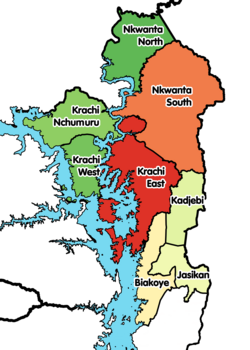
Districts of Oti Region
Ghana adm location map.svg
Red pog.svg
Nkwanta South Municipal Assembly
Location of Nkwanta South Municipal District within Oti
Coordinates: 8°15′25.92″N0°31′6.96″E / 8.2572000°N 0.5186000°E / 8.2572000; 0.5186000
CountryFlag of Ghana.svg  Ghana
Region Flag of Volta Region.png Oti
Capital Nkwanta
Government
  Municipal Chief ExecutiveJoseph Nyofam Ninkab
Population
 (2021)
  Total135,936
Time zone UTC+0 (GMT)
ISO 3166 code GH-OT-NS

Nkwanta South Municipal Assembly (French : Nkwanta Sud) is one of the eight districts in Oti Region, Ghana. Originally it was formerly part of the then-larger Nkwanta District on 10 March 1989, which was established by Legislative Instrument (L.I.) 1496, until the northern part of the district was split off to create Nkwanta North District on 29 February 2008, which was established by Legislative Instrument (L.I.) 1892; thus the remaining part has been renamed to become Nkwanta South District . However, on 14 November 2017 (effectively 15 March 2018), it was later elevated to municipal district assembly status to become Nkwanta South Municipal District; which was established by Legislative Instrument (L.I.) 2283. The municipality is located in the northern part of Oti Region and has Nkwanta as its capital town.

Contents

Villages

In addition to Nkwanta, the capital and administrative centre, Nkwanta South Municipality contains the following villages:

  • Gekrong
  • Bonakye
  • lebon
  • Siban
  • Bontibor
  • Akonsigewi
  • Brewaniase
  • Shiare
  • Chillinga
  • Kabre Akura
  • Kecheibi
  • Kanba
  • Keri
  • Odumasi
  • Kromase
  • Ofosu
  • Abrewankor
  • Pawa
  • Kue
  • Odomi
  • Krachi – Akura
  • Nabu
  • New Agou
  • Kenyintan
  • Nsuogya (Asodja)
  • Nyambong
  • Bontibor
  • Pusupu
  • Kpabo Akura
  • Sibi Central
  • Anebogewi
  • Sibi Hill Top
  • Tinjase
  • Okata
  • Kabiti

Sources

Related Research Articles

<span class="mw-page-title-main">Ahanta West Municipal District</span> Municipal District in Western, Ghana

Ahanta West Municipal District is one of the fourteen districts in Western Region, Ghana. Originally created as an ordinary district assembly in 1988 when it was known as Ahanta West District, which was created from the former Sekondi Takoradi Metropolitan Authority Council, until it was later elevated to municipal district assembly status on 15 March 2018 to become Ahanta West Municipal District. The municipality is located in the southeast part of Western Region and has Agona Nkwanta as its capital town.

<span class="mw-page-title-main">Bolgatanga Municipal District</span> Municipal District in Upper East, Ghana

Bolgatanga Municipal District is one of the fifteen districts in Upper East Region, Ghana. Originally created as an ordinary district assembly in 1988 when it was known as Bolgatanga District; which was established by Legislative Instrument (L.I.) 1438, until the southeast part of the district was split off by a decree of president John Agyekum Kufuor in August 2004 to create Talensi-Nabdam District; thus the remaining part was elevated to municipal district assembly status on the same year to become Bolgatanga Municipal District, which was established by Legislative Instrument (L.I.) 1797. However, on 15 March 2018, the eastern part of the district was later split off to create Bolgatanga East District, which was established by Legislative Instrument (L.I.) 2321; thus the remaining part has been retained as Bolgatanga Municipal District. The municipality is located in the central part of Upper East Region and has Bolgatanga as its capital town, which also serves as the capital of the Upper East Region.

<span class="mw-page-title-main">Jasikan District</span> District in Ghana

Jasikan District is one of the eight districts in Oti Region, Ghana. Originally created as an ordinary district assembly on 10 March 1989, which was created from the former Jasikan District Council, which it was established by Legislative Instrument (L.I.) 1464, until the western part of the district was split off to create Biakoye District on 29 February 2008, which was established by Legislative Instrument (L.I.) 1901; thus the remaining part has been retained as Jasikan District. The district assembly is located in the southern part of Oti Region and has Jasikan as its capital town.

<span class="mw-page-title-main">Kadjebi District</span> District in Ghana

Kadjebi District is one of the eight districts in Oti Region, Ghana. Originally created as an ordinary district assembly on 10 March 1989, which was created from the former Jasikan District Council, which it was established by Legislative Instrument (L.I.) 1465. The district assembly is located in the southern part of Oti Region and has Kadjebi as its capital town.

<span class="mw-page-title-main">Krachi West District</span> District in Ghana

Krachi West District is one of the eight districts in Oti Region, Ghana. Originally it was formerly part of the then-larger Krachi District on 10 March 1989, which was established by Legislative Instrument (L.I.) 1501, until the eastern part of the district was split off to create Krachi East District on 4 August 2004, which was established by Legislative Instrument (L.I.) 1747; thus the remaining part has been renamed to become Krachi West District. However, on 28 June 2012, the northern part of the district was split off to create Krachi Nchumuru District, which was established by Legislative Instrument (L.I.) 2078; thus the remaining part has been retained as Krachi West District. The district assembly is located in the northern part of Oti Region and has Kete Krachi as its capital town.

<span class="mw-page-title-main">North Tongu District</span> District in Ghana

North Tongu District is one of the eighteen districts in Volta Region, Ghana. Originally it was formerly part of the then-larger and original North Tongu District on 10 March 1989, with Adidome as its capital town, which was created from the former Tongu District Council, until the western part of the district was split off to create a new North Tongu District on 28 June 2012, with Battor Dugame as its capital town, which was established by Legislative Instrument (L.I.) 2081; thus the remaining part has been renamed as Central Tongu District, with Adidome as its capital town, which was established by Legislative Instrument (L.I.) 2077. The district assembly is located in Addidome, near Adidome Senior High School (Adisec) the southwest part of Volta Region and has Battor Dugame as its capital town.

<span class="mw-page-title-main">Krachi East Municipal District</span> Municipal District in Ghana

Krachi East Municipal District is one of the eight districts in Oti Region, Ghana. Originally it was formerly part of the then-larger Krachi District on 1988, until the eastern part of the district was split off to create Krachi East District on 19 August 2004, which was established by Legislative Instrument (L.I.) 1755; thus the remaining part has been renamed to become Krachi West District. However, on 14 November 2017, it was later elevated to municipal district assembly status to become Krachi East Municipal District; which was established by Legislative Instrument (L.I.) 2281. The municipality is located in the northern part of Oti Region and has Dambai as its capital town.

<span class="mw-page-title-main">Bawku Municipal District</span> Municipal district in Upper East region, Ghana

Bawku Municipal District is one of the fifteen districts in Upper East Region, Ghana. Originally created as an ordinary district assembly in 1988 when it was known as Bawku East District; which was established by Legislative Instrument (L.I.) 1439, until the southern part of the district was split off by a decree of president John Agyekum Kufuor in August 2004 to create Garu-Tempane District; thus the remaining part was elevated to municipal district assembly status on the same year to become Bawku Municipal District. However, on 28 June 2012, two parts of the district were later split off to create Binduri District and Pusiga District respectively; thus the remaining part has been retained as Bawku Municipal District. The municipality is located in the eastern part of Upper East Region and has Bawku as its capital town.

<span class="mw-page-title-main">Nkwanta North District</span> District in Ghana

Nkwanta North District is one of the nine (9) districts in Oti Region, Ghana. Originally it was formerly part of the then-larger Nkwanta District on 10 March 1989, until the northern part of the district was split off to create Nkwanta North District on 29 February 2008, which was established by Legislative Instrument (L.I.) 1846; thus the remaining part has been renamed to become Nkwanta South District, which was later elevated to municipal district assembly status on 14 November 2017 to become Nkwanta South Municipal District; which was established by Legislative Instrument (L.I.) 2283. The district assembly is located in the northern part of Oti Region and has Kpassa as its capital town.

<span class="mw-page-title-main">Nkwanta District</span> Former District in Ghana

Nkwanta District is a former district that was located in Volta Region, Ghana. Originally created as an ordinary district assembly on 10 March 1989. However on 29 February 2008, it was split off into two new districts: Nkwanta South District and Nkwanta North District. The district assembly was located in the northern part of Volta Region and had Nkwanta as its capital town.

Bimbilla is the capital town of Nanumba North District, a district in the Northern Region of Ghana. It is located in the East of the region, and is near the Oti River. The location is situated within the range of 8.5° north to 9.25° north latitude, and between 0.57° east to 0.5° east longitude. It borders five municipalities: Yendi Municipal to the north, Mion Municipal to the northwest, East Gonja Municipal to the west and southwest, Nanumba South Municipal to the south and east, and Zabzugu Municipal to the north-northeast.

<span class="mw-page-title-main">Akatsi South District</span> District in Ghana

Akatsi South District is one of eighteen districts in Volta Region, Ghana. Originally it was formerly part of the then-larger Akatsi District on 10 March 1989, which was created from the former Anlo District Council, until the northern part of the district was split off to create Akatsi North District on 28 June 2012; under the government by then-president John Atta Mills. Thus the remaining part has been renamed as Akatsi South District. The district assembly is located in the southeast part of Volta Region and has Akatsi as its capital town.

<span class="mw-page-title-main">Ho Municipal District</span> Municipal District in Ghana

Ho Municipal District is one of the eighteen districts in Volta Region, Ghana. Originally created as an ordinary district assembly on 10 March 1989 when it was known as Ho District, until the southern part of the district was split off by a decree of president John Agyekum Kufuor on 13 August 2004 to create Adaklu-Anyigbe District; thus the remaining part has been retained as Ho District. However on 28 June 2012, the western part of the district was later split off to create Ho West District; thus the remaining part was elevated to municipal district assembly status on that same year to become Ho Municipal District, which was established by Legislative Instrument (L.I.) 2074. The municipality is located in the central part of Volta Region and has Ho as its capital town.

<span class="mw-page-title-main">La Dade Kotopon Municipal District</span> Municipal District in Ghana

La Dade Kotopon Municipal District is one of the twenty-nine districts in Greater Accra Region, Ghana. Originally it was formerly part of the then-larger Accra Metropolitan District in 1988, until the eastern portion of the district was split off to create La Dade Kotopon Municipal District on 28 June 2012; thus the remaining part has been retained as Accra Metropolitan District. The municipality is located in the central part of Greater Accra Region and has La as its capital town.

<span class="mw-page-title-main">Oti Region</span> Region of Ghana

The Oti Region is one of the six newly created regions of Ghana in December 2018. The region was carved out of the northern part of the Volta Region and will be in fulfillment of a campaign promise made by New Patriotic Party. Prior to the 2016 Ghanaian general election, the then candidate Nana Akufo-Addo declared that when elected, he would explore the possibility of creating new regions out of some of the existing regions in Ghana in order to bring government closer to citizens. The Region was inaugurated on May 14, 2019. It has Dambai as its Regional Capital. The people of Oti region have for more than 60 years always wanted to have a region of their own before its creation in 2018 by the President Nana Addo Dankwa Akufo-Addo led government in December 2018.

<span class="mw-page-title-main">La Nkwantanang Madina Municipal District</span> Municipal District in Ghana

La Nkwantanang Madina Municipal District is one of the twenty-nine districts in Greater Accra Region, Ghana. Originally it was formerly part of the then-larger Ga East District in 2004, until the eastern part of the district was split off to create La-Nkwantanang-Madina Municipal District on 28 June 2012, which was established by Legislative Instrument (L.I.) 2131; thus the remaining part has been retained as Ga East Municipal District. The municipality is located in the western part of Greater Accra Region and has Madina as its capital town.

<span class="mw-page-title-main">Krachi Nchumuru (district)</span> District in Ghana

Krachi Nchumuru District is one of the eight districts in Oti Region, Ghana. Originally it was formerly part of Krachi West District on 4 August 2004, which was established by Legislative Instrument (L.I.) 1747. until the northern part of the district was split off to create Krachi Nchumuru District on 28 June 2012, which was established by Legislative Instrument (L.I.) 2084; thus the remaining part has been retained as Krachi West District. The district assembly is located in the northern part of Oti Region and has Chinderi as its capital town.

<span class="mw-page-title-main">Ga North Municipal District</span> Municipal District in Ghana

Ga North Municipal District is one of the twenty-nine districts in Greater Accra Region, Ghana. Originally it was formerly part of the then-larger Ga West District in 2004, until the eastern part of the district was split off to create Ga North Municipal District on 15 March 2018, which was supported by Legislative Instrument (L.I.) 2314; thus the remaining part has been retained as Ga West Municipal District. The municipality is located in the western part of Greater Accra Region and has Ofankor as its capital town.

<span class="mw-page-title-main">Kpone Katamanso Municipal District</span> District in Greater Accra region, Ghana

Kpone-Katamanso Municipal District is one of the twenty-nine districts in Greater Accra Region, Ghana. Originally it was formerly part of the then-larger Tema Municipal District, which was created from the former Tema District Council, until the eastern portion of the district was split off to create Kpone-Katamanso District on 28 June 2012, which was established by Legislative Instrument (L.I.) 2031; thus the remaining part has been retained as Tema Metropolitan District. However on 15 March 2018, it was later elevated to municipal district assembly status to become Kpone-Katamanso Municipal District, which was established by Legislative Instrument (L.I.) 2271. The municipality is located in the central part of Greater Accra Region and has Kpone as its capital town.

<span class="mw-page-title-main">Okere District</span> District in Ghana

Okere District is one of the thirty-three districts in Eastern Region, Ghana. Originally it was formerly part of the then-larger Akuapim North District in 1988, which was created from the former Akuapim District Council; until it was elevated to municipal district assembly status on 15 March 2012 to become Akuapim North Municipal District.

References

    8°15′25.92″N0°31′6.96″E / 8.2572000°N 0.5186000°E / 8.2572000; 0.5186000