
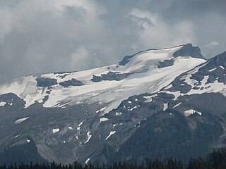
Mount Baker, also known as Koma Kulshan or simply Kulshan, is a 10,781 ft (3,286 m) active glacier-covered andesitic stratovolcano in the Cascade Volcanic Arc and the North Cascades of Washington State in the United States. Mount Baker has the second-most thermally active crater in the Cascade Range after Mount St. Helens. About 30 miles (48 km) due east of the city of Bellingham, Whatcom County, Mount Baker is the youngest volcano in the Mount Baker volcanic field. While volcanism has persisted here for some 1.5 million years, the current volcanic cone is likely no more than 140,000 years old, and possibly no older than 80–90,000 years. Older volcanic edifices have mostly eroded away due to glaciation.

The Mount Baker–Snoqualmie National Forest in Washington is a National Forest extending more than 140 miles (230 km) along the western slopes of the Cascade Range from the Canada–US border to the northern boundary of Mount Rainier National Park. Administered by the United States Forest Service, the forest is headquartered in Everett. There are local ranger district offices in North Bend and Skykomish.
Tucker Glacier is a major valley glacier of Victoria Land, Antarctica, about 90 nautical miles long, flowing southeast between the Admiralty Mountains and the Victory Mountains to the Ross Sea. There is a snow saddle at the glacier's head, just west of Homerun Range, from which the Ebbe Glacier flows northwestward.
State Route 542 (SR 542) is a 57.24-mile-long (92.12 km) state highway in the U.S. state of Washington, serving Mount Baker in Whatcom County. SR 542 travels east as the Mount Baker Highway from an interchange with Interstate 5 (I-5) in Bellingham through the Nooksack River valley to the Mt. Baker Ski Area at Austin Pass. It serves as the main highway to Mount Baker and the communities of Deming, Kendall, and Maple Falls along the Nooksack River. The highway was constructed in 1893 by Whatcom County as a wagon road between Bellingham and Maple Falls and was added to the state highway system as a branch of State Road 1 in 1925. The branch was transferred to Primary State Highway 1 (PSH 1) during its creation in 1937 and became SR 542 during the 1964 highway renumbering.

Lambert Glacier is a major glacier in East Antarctica. At about 80 km (50 mi) wide, over 400 km (250 mi) long, and about 2,500 m (8,200 ft) deep, it is the world's largest glacier. It drains 8% of the Antarctic ice sheet to the east and south of the Prince Charles Mountains and flows northward to the Amery Ice Shelf. It flows in part of Lambert Graben and exits the continent at Prydz Bay.

Boulder Glacier is located on the southeast slope of Mount Baker, a stratovolcano near the Pacific coast of North America in the Cascade Range of Washington. Boulder Glacier is the sixth largest on Mount Baker with an area of 1.3 square miles (3.4 km2). It flows from the summit crater between Grant Peak and Sherman Peak to about 5,000 ft (1,500 m). It is noteworthy for retreating 1,610 ft (490 m) between 1987 and 2008, leaving newly exposed rock and soil behind.

Coleman Glacier is located on Mount Baker in the North Cascades of the U.S. state of Washington. Between 1850 and 1950, Coleman Glacier retreated 8,200 ft (2,500 m). During a cooler and wetter period from 1950 to 1979, the glacier advanced 2,480 ft (760 m) but between 1980 and 2006 retreated back 1,443 ft (440 m). Situated on the west slopes of Mount Baker, Coleman Glacier is bordered by the Roosevelt Glacier to the north and the Heliotrope Ridge to the south.

Gildea Glacier is a glacier 10 kilometres (6 mi) long and 5 kilometres (3 mi) wide flowing southwestward from Craddock Massif between Mount Slaughter and Mount Atkinson into Nimitz Glacier, in the Sentinel Range of the Ellsworth Mountains, Antarctica. The upper portion of the glacier also receives ice from Hammer Col and southern Vinson Massif.

Easton Glacier is one of the more prominent alpine glaciers on Mount Baker in the North Cascades of Washington state, United States. Named for Charles F. Easton of Bellingham, who did much to preserve the history of Mount Baker, it is positioned on the south face of the mountain and flanked by Squak and Deming Glaciers.
Hough Glacier is a glacier in central Doyran Heights in the Sentinel Range of Ellsworth Mountains, Antarctica, rising just south of Mount Tuck and flowing east-southeast for 10 nautical miles between Guerrero Glacier and Remington Glacier. It was first mapped by the United States Geological Survey from surveys and U.S. Navy air photos, 1957–59, and was named by the Advisory Committee on Antarctic Names for William S. Hough, who made ionosphere studies at South Pole Station in 1957.
Bastile Glacier is located on the north slopes of Mount Baker in the North Cascades, U.S. state of Washington.

Deming Glacier is located on Mount Baker in the North Cascades of the U.S. state of Washington. Between 1850 and 1950, Deming Glacier retreated 7,217 ft (2,200 m). During a cooler and wetter period from 1950 to 1979, the glacier advanced 2,060 ft (630 m) but between 1980 and 2006 retreated back 1,140 ft (350 m). Situated on the southwest slopes of Mount Baker, Deming Glacier is bordered by the Easton Glacier to the east and the Black Buttes ridge to the west.

Hadley Glacier is located on Mount Baker in the North Cascades of the U.S. state of Washington. Situated on the north slopes of Mount Baker, Hadley Glacier is north of Hadley Peak on a spur from Mount Baker.
Mazama Glacier is located on Mount Baker in the North Cascades of the U.S. state of Washington. Between 1850 and 1950, Mazama Glacier retreated 7,700 ft (2,300 m). During a cooler and wetter period from 1950 to 1979, the glacier advanced 1,476 ft (450 m) but between 1980 and 2006 retreated back 1,509 ft (460 m). Situated on the north slopes of Mount Baker, Mazama Glacier is bordered by the Park Glacier to the south and Rainbow Glacier to the east.
Rainbow Glacier is located on the northeast slopes of Mount Baker in the North Cascades of the U.S. state of Washington. Rainbow Glacier descends to nearly 4,500 ft (1,400 m) to the north of Lava Divide. In the middle of its course, Rainbow Glacier is connected to Park Glacier to its south and Mazama Glacier to the west. Between 1850 and 1950, Rainbow Glacier retreated 4,494 ft (1,370 m). During a cooler and wetter period from 1950 to 1979, the glacier advanced 1,679 ft (512 m) but between 1980 and 2006 retreated back 1,345 ft (410 m).

Roosevelt Glacier is located on the north slopes of Mount Baker in the North Cascades of the U.S. state of Washington. Roosevelt Glacier descends to nearly 5,000 ft (1,500 m) at Chromatic Moraine. In the middle of its course, Roosevelt Glacier is connected to Coleman Glacier to its south.
Sholes Glacier is located on the northeast slopes of Mount Baker in the North Cascades of the U.S. state of Washington. The glacier lies on the north side of the ridge known as The Portals. Between 1850 and 1950, Sholes Glacier retreated 3,838 ft (1,170 m). During a cooler and wetter period from 1950 to 1979, the glacier advanced 187 ft (57 m) but between 1980 and 2006 retreated back 278 ft (85 m).
Squak Glacier is located on the southeast slopes of Mount Baker in the North Cascades of the U.S. state of Washington. Squak Glacier is connected to Easton Glacier to the east and Talum Glaciers to the west. Between 1850 and 1950, Squak Glacier retreated 8,202 ft (2,500 m). During a cooler and wetter period from 1950 to 1979, the glacier advanced 305 ft (93 m) but between 1980 and 2006 retreated back 869 ft (265 m).
The Talum Glaciers are located on the southeast slopes of Mount Baker in the North Cascades of the U.S. state of Washington. The glaciers are connected to Squak Glacier to the west. Between 1850 and 1950, the Talum Glaciers retreated 6,479 ft (1,975 m). During a cooler and wetter period from 1950 to 1979, the glaciers advanced 902 ft (275 m) but between 1980 and 2006 retreated back 951 ft (290 m).

Thunder Glacier is located on the west slopes of Mount Baker in the North Cascades of the U.S. state of Washington. The glacier descends to the west on the north side of the Black Buttes.
