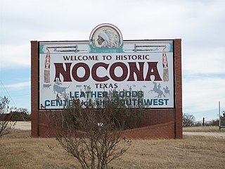
Nocona is a city along U.S. Highway 82 and State Highway 175 in Montague County, Texas, United States. The population was 3,033 at the 2010 census. The city, its lake, and its resurgence as a regional travel destination were featured in the June 2012 edition of Texas Highways magazine.

Arnold Palmer Regional Airport is in Westmoreland County, Pennsylvania, United States, two miles (3 km) southwest of Latrobe and about 33 miles (53 km) southeast of Pittsburgh. It was formerly Westmoreland County Airport; it was renamed in September 1999 for Arnold Palmer as part of his 70th birthday celebration. Palmer learned to fly at the airport, and the dedication ceremony included Governor Tom Ridge and a flyover of three A-10s of the Pennsylvania Air National Guard.

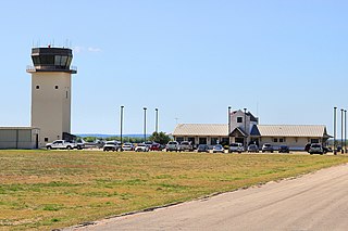
Wichita Falls Regional Airport is a public and military use airport six miles north of Wichita Falls in Wichita County, Texas. Its runways and taxiways are shared with Sheppard Air Force Base; most operations are military, but American Eagle flies to Dallas/Fort Worth International Airport.
New Braunfels National Airport is a public use airport in Guadalupe County, Texas, United States. It is owned by the city of New Braunfels and located four nautical miles east of its central business district. Formerly known as New Braunfels Regional Airport, it is included in the National Plan of Integrated Airport Systems for 2011–2015, which categorized it as a general aviation facility.
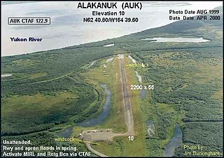
Alakanuk Airport is a state-owned public-use airport located 2 nautical miles (3.7 km) west of the central business district of Alakanuk, a city in the Kusilvak Census Area of the U.S. state of Alaska.

South Alabama Regional Airport at Bill Benton Field, formerly known as Andalusia-Opp Airport, is a public use airport in Covington County, Alabama, United States. It is located four nautical miles east of the central business district of Andalusia and about 9 miles (14 km) west of Opp. The airport is governed by the South Alabama Regional Airport Authority, with members appointed by the Andalusia City Council, the Opp Council, and the Covington County Commission.

San Marcos Regional Airport is a public use airport located in Caldwell County, Texas, United States. It is four nautical miles (7 km) east of the central business district of San Marcos, a city that is mostly in Hays County. The airport is owned by the City of San Marcos and operated by Texas Aviation Partners. It is located east of the border of Caldwell County and Hays County. Before it was operated as a civilian airport it was known as Gary Air Force Base.

Abbeville Municipal Airport is a city-owned, public-use airport located three nautical miles north of the central business district of Abbeville, a city in Henry County, Alabama, United States. It is the only airport that serves the city of Abbeville.

Isbell Field is a city-owned public-use airport located two nautical miles north of the central business district of Fort Payne, a city in DeKalb County, Alabama, United States. According to the FAA's National Plan of Integrated Airport Systems for 2009–2013, it is categorized as a general aviation facility.
Guntersville Municipal Airport, also known as Joe Starnes Field, is a city-owned public-use airport located three nautical miles northeast of the central business district of Guntersville, a city in Marshall County, Alabama, United States. According to the FAA's National Plan of Integrated Airport Systems for 2009–2013, it is categorized as a general aviation facility.

Scottsboro Municipal Airport, also known as Word Field, is a city-owned public-use airport located two nautical miles (3.7 km) northeast of the central business district of Scottsboro, a city in Jackson County, Alabama, United States. According to the FAA's National Plan of Integrated Airport Systems for 2009–2013, it is categorized as a general aviation facility.

Russellville Municipal Airport, also known as Bill Pugh Field, is a city-owned public-use airport located three nautical miles southeast of the central business district of Russellville, a city in Franklin County, Alabama, United States. It is included in the FAA's National Plan of Integrated Airport Systems for 2011–2015, which categorized it as a general aviation facility.
Fort Worth Spinks Airport is a city-owned, public-use airport located 14 nautical miles (26 km) south of the central business district of Fort Worth, in Tarrant County, Texas, United States. It is the newest of the three airports that are owned by the City of Fort Worth and it serves the cities of Fort Worth, Burleson, and Mansfield. The airport is located at the intersection of Interstate 35W and HWY 1187 and serves as a reliever airport for Fort Worth Meacham International Airport and Dallas–Fort Worth International Airport and has Class D designation.
Sack-O-Grande Acroport, also known as the Harbican Airport, was an airport in unincorporated Harris County, Texas, United States. It was located seven nautical miles (13 km) north of the central business district of the city of Katy, and seven nautical miles northeast of Houston Executive Airport.
Livingston Municipal Airport is a city-owned, public-use airport located five nautical miles southwest of the central business district of Livingston, a city in Polk County, Texas, United States. According to the FAA's National Plan of Integrated Airport Systems for 2009–2013, it is categorized as a general aviation facility.
Cotulla–La Salle County Airport is a public use airport located one nautical mile (1.85 km) northeast of the central business district of Cotulla, a city in La Salle County, Texas, United States. It is owned by the City of Cotulla and La Salle County. According to the FAA's National Plan of Integrated Airport Systems for 2009–2013, it is categorized as a general aviation facility.
Brundidge Municipal Airport was a city-owned, public-use airport located one nautical mile northeast of the central business district of the Brundidge, a city in Pike County, Alabama, United States. It is currently closed indefinitely.

Bruce Brothers Huntsville Regional Airport, also known as Huntsville Municipal Airport, is a city-owned, public-use airport located two nautical miles (4 km) northwest of the central business district of Huntsville, a city in Walker County, Texas, United States. It is included in the National Plan of Integrated Airport Systems for 2011–2015, which categorized it as a general aviation facility.
Bishop Municipal Airport is a city-owned public-use airport located three nautical miles northeast of the central business district of Bishop, a city in Nueces County, Texas, United States.
Kittyhawk Airport was a privately owned public-use airport located one nautical mile (2 km) northwest of the central business district of Allen, a city in Collin County, Texas, United States.
