
The Arctic Archipelago, also known as the Canadian Arctic Archipelago, is a group of islands north of the Canadian mainland.

Auburndale is a city in Polk County, Florida, United States. The population was 11,032 at the 2000 census. According to the U.S Census estimates of 2005, the city had a population of 12,381. It is part of the Lakeland–Winter Haven Metropolitan Statistical Area.

Chimborazo is a province in the central Ecuadorian Andes. It is a home to a section of Sangay National Park. The capital is Riobamba. The province contains Chimborazo, Ecuador's highest mountain.

Pichincha is a province of Ecuador located in the northern sierra region; its capital and largest city is Quito. It is bordered by Imbabura and Esmeraldas to the north, Cotopaxi and Santo Domingo de los Tsáchilas to the south, Napo and Sucumbíos to the east, and Esmeraldas and Santo Domingo de los Tsáchilas to the west.

Cayambe is a canton in the northeast of the province of Pichincha, in northern Ecuador, South America. The canton is named after the Cayambe, a 5,800-meter-high snow-covered stratovolcano in the east of the canton. The main part of the canton occupies the eastern portion of the Pisque river basin and is surrounded by volcanoes.
Pedro Moncayo is a canton in the north of the Pichincha Province, Ecuador. The seat of the canton is the city of Tabacundo. The canton is named after politician Pedro Moncayo. The canton is separated by the Mojanda volcano from the canton of Otavalo in the province of Imbabura in the north. It borders the same-province cantons of Cayambe and Quito.
Puerto Quito is a canton in Pichincha Province, Ecuador. It has only one parish, the urban parish of Puerto Quito, which is also the seat of the canton.
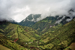
San Miguel de los Bancos, or simply Los Bancos, is a canton in the province of Pichincha, Ecuador. The long name of the town refers to dedication of the area to the archangel Michael. Local tradition attributes the "Los Bancos" part of the name to the use of tree trunks as benches at the junction of the through road from Quito to Esmeraldas with the road into the Rio Blanco valley.
Licking Creek is a 56.6-mile-long (91.1 km) tributary of the Potomac River in Pennsylvania and Maryland in the United States.

Town Creek is a 41.6-mile-long (66.9 km) tributary stream of the Potomac River in the U.S. states of Maryland and Pennsylvania. The creek is formed from the confluence of Sweet Root Creek and Elk Lick Creek, about 0.5 miles (0.8 km) south of Buchanan State Forest in Bedford County, Pennsylvania. Town Creek flows south along the base of Warrior Mountain into Allegany County, Maryland. The Chesapeake and Ohio Canal crosses it at the Town Creek Aqueduct. It empties into the Potomac about 4 miles (6 km) east of Oldtown, Maryland.
Fifteenmile Creek is a 19.9-mile-long (32.0 km) tributary stream of the Potomac River in the U.S. states of Maryland and Pennsylvania. The creek enters the Potomac River through Maryland's Green Ridge State Forest.
Mosquito Creek is a 21.8-mile-long (35.1 km) tributary of the West Branch Susquehanna River in central Pennsylvania in the United States.
Cajamarca District is one of twelve districts of the province Cajamarca in Peru.

El Pan Canton is a canton of Ecuador, located in the Azuay Province. Its capital is the town of El Pan. Its population at the 2001 census was 3,075.
Sevilla de Oro Canton is a canton of Ecuador, located in the Azuay Province. Its capital is the town of Sevilla de Oro. Its population at the 2001 census was 5,234.

Baronick Glacier is a glacier 6 nautical miles (11 km) southwest of Mount Cocks, in the Royal Society Range, draining into the Skelton Glacier to the west. It was named by the Advisory Committee on Antarctic Names in 1963 for Chief Aviation Ordnanceman Michael P. Baronick, of U.S. Navy Squadron VX-6, who wintered at Williams Air Operating Facility at McMurdo Sound in 1956 and was in Antarctica for several summer seasons. Baronick, with a party of three, was in command of the Beardmore Air Operating Facility established on October 28, 1956, at 84°56′S166°0′W.

Thomas Glacier is a roughly Z-shaped glacier which drains the southeast slopes of Vinson Massif and flows for 17 nautical miles (31 km) through the south part of the Sentinel Range, Ellsworth Mountains, leaving the range between Doyran and Petvar Heights south of Johnson Spur.
Aster Glacier is an Antarctic glacier descending the east slope of Craddock Massif and flowing between Elfring Peak and Willis Ridge to Thomas Glacier in the Sentinel Range, Ellsworth Mountains in Antarctica. It was named by the Advisory Committee on Antarctic Names in 2006, after Richard C. Aster, Professor of Geophysics and Department Head of Geosciences at Colorado State University, whose research in Antarctica includes volcanological studies at the Mount Erebus volcano observatory on Ross Island, glaciological, oceanic, and tectonic seismic source studies, seismic tomography, ice shelf studies, and the coupling of solid Earth geophysics and Antarctic ice sheet evolution.

Orizari Glacier is the 3 nautical miles long and 0.5 nautical miles wide glacier in Veregava Ridge on the east side of Sentinel Range in Ellsworth Mountains, Antarctica. It is draining the north slopes of Mount Waldron, and flowing north-northwestwards to join Dater Glacier west of Sipey Peak.
Divdyadovo Glacier is the 4.3 nautical miles long and 1.6 nautical miles wide glacier in Petvar Heights on the southeast side of Sentinel Range in Ellsworth Mountains, Antarctica situated northeast of Carey Glacier and southeast of Drama Glacier. It is flowing northeastwards, then north of Ruset Peak turning east-southeastwards to leave the range southeast of Long Peak.


