Related Research Articles

The Astley Green Colliery Museum is a museum run by the Red Rose Steam Society in Astley near Tyldesley in Greater Manchester, England. Before becoming a museum, the site was a working colliery that produced coal from 1912 to 1970; it is now protected as a Scheduled Monument. The museum occupies a 15-acre (6 ha) site by the Bridgewater Canal which has the only surviving pit headgear and engine house on the Lancashire Coalfield.
The Astley and Tyldesley Collieries Company formed in 1900 owned coal mines on the Lancashire Coalfield south of the railway in Astley and Tyldesley, then in the historic county of Lancashire, England. The company became part of Manchester Collieries in 1929 and some of its collieries were nationalised in 1947.
Tyldesley Coal Company was a coal mining company formed in 1870 in Tyldesley, on the Manchester Coalfield in the historic county of Lancashire, England that had its origins in Yew Tree Colliery, the location for a mining disaster that killed 25 men and boys in 1858.
Bedford Colliery, also known as Wood End Pit, was a coal mine on the Manchester Coalfield in Bedford, Leigh, Lancashire, England. The colliery was owned by John Speakman, who started sinking two shafts on land at Wood End Farm in the northeast part of Bedford, south of the London and North Western Railway's Tyldesley Loopline in about 1874. Speakman's father owned Priestners, Bankfield, and Broadoak collieries in Westleigh. Bedford Colliery remained in the possession of the Speakman family until it was amalgamated with Manchester Collieries in 1929.
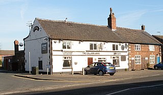
Great Boys Colliery was a coal mine operating on the Manchester Coalfield in the second half of the 19th century in Tyldesley, then in the historic county of Lancashire, England. It was sunk on Great Boys farm, which in 1778 was described as a "messuage with eight Cheshire acres of land" on the north side of Sale Lane west of the Colliers Arms public house. It was owned by William Atkin and sold in 1855 to mineowners, John Fletcher of Bolton and Samuel Scowcroft. By 1869 their partnership was dissolved and the company became John Fletcher and Sons in 1877. Shafts were sunk for a colliery on Pear Tree Farm on the corner of Mort Lane and Sale Lane which appear in the 1867 Mines Lists and became part of Great Boys Colliery. Fletcher and Schofield were granted permission to construct a mineral railway to join the London and North Western Railway's Tyldesley Loopline in 1868 but there is no evidence that it was built. The colliery closed before 1885. The colliery accessed the Brassey mine at about 170 yards and the Six Foot mine at 182 yards. The deeper coal seams were accessed by New Lester Colliery.

The Manchester Coalfield is part of the South Lancashire Coalfield, the coal seams of which were laid down in the Carboniferous Period. Some easily accessible seams were worked on a small scale from the Middle Ages, and extensively from the beginning of the Industrial Revolution in the early 19th century until the last quarter of the 20th century. The Coal Measures lie above a bed of Millstone Grit and are interspersed with sandstones, mudstones, shales, and fireclays. The Lower Coal Measures occupy the high ground of the West Pennine Moors above Bolton and are not worked in the Manchester Coalfield. The most productive of the coal measures are the lower two thirds of the Middle Coal Measures where coal is mined from seams between the Worsley Four Foot and Arley mines. The deepest and most productive collieries were to the south of the coalfield. The coalfield is affected by the northwest to southeast aligned Pendleton Fault along the Irwell Valley and the Rossendale Valley anticline. The Coal Measures generally dip towards the south and west. Numerous other smaller faults affect the coalfield. The Upper Coal Measures are not worked in the Manchester Coalfield.
New Lester Colliery was a coal mine operating on the Manchester Coalfield from the second half of the 19th century to the first half of the 20th century in Tyldesley, then in the historic county of Lancashire, England. It was owned by James Roscoe and two shafts were sunk in about 1865 on the east side of Mort Lane on the road to Little Hulton where Roscoe had sunk the Peel Hall and New Watergate pits.
Bridgewater Collieries originated from the coal mines on the Manchester Coalfield in Worsley in the historic county of Lancashire owned by Francis Egerton, 3rd Duke of Bridgewater in the second half of the 18th century. After the Duke's death in 1803 his estate was managed by the Bridgewater Trustees until the 3rd Earl of Ellesmere inherited the estates in 1903. Bridgewater Collieries was formed in 1921 by the 4th Earl. The company merged with other prominent mining companies to form Manchester Collieries in 1929.

Astley Green Colliery was a coal mine in Astley, Greater Manchester, then in the historic county of Lancashire, England. It was the last colliery to be sunk in Astley. Sinking commenced in 1908 by the Pilkington Colliery Company, a subsidiary of the Clifton and Kersley Coal Company, at the southern edge of the Manchester Coalfield, working the Middle Coal Measures where they dipped under the Permian age rocks under Chat Moss. The colliery was north of the Bridgewater Canal. In 1929 it became part of Manchester Collieries, and in 1947 was nationalised and integrated into the National Coal Board. It closed in 1970, and is now Astley Green Colliery Museum.
Gin Pit was a coal mine operating on the Lancashire Coalfield from the 1840s in Tyldesley, Greater Manchester then in the historic county of Lancashire, England. It exploited the Middle Coal Measures of the Manchester Coalfield and was situated to the south of the Tyldesley Loopline.
St George's Colliery, Back o't' Church, was a coal mine operating on the Manchester Coalfield after 1866 in Tyldesley, Greater Manchester, then in the historic county of Lancashire, England. It was owned by Sir Edmund Buckley. The colliery was situated to the south of Tyldesley Station on the Tyldesley Loopline and named after St George's Church.
Yew Tree Colliery was a coal mine operating on the Manchester Coalfield after 1845 in Tyldesley, Greater Manchester, then in the historic county of Lancashire, England.
Cleworth Hall Colliery was a coal mine operating on the Manchester Coalfield after 1874 in Tyldesley, Greater Manchester, then in the historic county of Lancashire, England.
Combermere Colliery was a coal mine operating on the Manchester Coalfield after 1867 in Shakerley, Tyldesley, Greater Manchester, then in the historic county of Lancashire, England.
Peelwood Colliery was a coal mine operating on the Manchester Coalfield after 1883 in Shakerley, Tyldesley, Greater Manchester, then in the historic county of Lancashire, England.
Shakerley Colliery was a coal mine on the Manchester Coalfield near Shakerley, Tyldesley, Greater Manchester, then in the historic county of Lancashire, England. It was sunk in 1867 and was operating in 1878. The colliery on Shakerley Common had a single shaft which was sunk to the Rams mine at 300 feet by George Green to exploit the Middle Coal Measures of the Lancashire Coalfield and became part of the Tyldesley Coal Company in 1870. It had the first iron headgear in the country but closed by 1886.
Nelson Pit was a coal mine operating on the Manchester Coalfield from the 1830s or 1840s in Shakerley, Tyldesley, Greater Manchester, then in the historic county of Lancashire, England.
Wellington Colliery was a coal mine operating on the Manchester Coalfield before 1869 in Tyldesley, Greater Manchester, then in the historic county of Lancashire, England.
Mosley Common Colliery was a coal mine originally owned by the Bridgewater Trustees operating on the Manchester Coalfield after 1866 in Mosley Common, Greater Manchester, then in the historic county of Lancashire, England. The colliery eventually had five shafts and became the largest colliery on the Lancashire Coalfield with access to around 270 million tons of coal under the Permian rocks to the south.
References
Citations
- ↑ NW Division map, cmhrc.co.uk, archived from the original on 19 July 2011, retrieved 18 February 2011
- ↑ Hayes 2004, p. 55
- ↑ Hayes 2004, p. 58
- ↑ Hayes 2004, p. 57
- 1 2 Historic England, "Nook Colliery (1480583)", Research records (formerly PastScape), retrieved 10 May 2014
- ↑ Changing Shifts Nook Colliery, Art UK , retrieved 10 May 2014
Bibliography
- Hayes, Geoffrey (2004), Collieries and their Railways in the Manchester Coalfields, Landmark, ISBN 1-84306-135-X