Mount Baker, also known as Koma Kulshan or simply Kulshan, is a 10,781 ft (3,286 m) active glacier-covered andesitic stratovolcano in the Cascade Volcanic Arc and the North Cascades of Washington in the United States. Mount Baker has the second-most thermally active crater in the Cascade Range after Mount St. Helens. About 30 miles (48 km) due east of the city of Bellingham, Whatcom County, Mount Baker is the youngest volcano in the Mount Baker volcanic field. While volcanism has persisted here for some 1.5 million years, the current volcanic cone is likely no more than 140,000 years old, and possibly no older than 80–90,000 years. Older volcanic edifices have mostly eroded away due to glaciation.
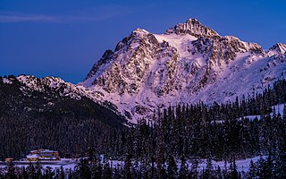
Mount Shuksan is a glaciated massif in the North Cascades National Park. Shuksan rises in Whatcom County, Washington immediately to the east of Mount Baker, and 11.6 miles (18.7 km) south of the Canada–US border. The mountain's name Shuksan is derived from the Lummi word [šéqsən], said to mean "high peak". The highest point on the mountain is a three-sided peak known as Summit Pyramid.

The Nooksack River is a river in western Whatcom County of the northwestern U.S. state of Washington, draining extensive valley systems within the North Cascades around Mount Shuksan, Mount Baker and the Twin Sisters, and a portion of Fraser Lowland south of the Canada–United States border.
State Route 542 (SR 542) is a 57.24-mile-long (92.12 km) state highway in the U.S. state of Washington, serving Mount Baker in Whatcom County. SR 542 travels east as the Mount Baker Highway from an interchange with Interstate 5 (I-5) in Bellingham through the Nooksack River valley to the Mt. Baker Ski Area at Austin Pass. It serves as the main highway to Mount Baker and the communities of Deming, Kendall, and Maple Falls along the Nooksack River. The highway was constructed in 1893 by Whatcom County as a wagon road between Bellingham and Maple Falls and was added to the state highway system as a branch of State Road 1 in 1925. The branch was transferred to Primary State Highway 1 (PSH 1) during its creation in 1937 and became SR 542 during the 1964 highway renumbering.

The Black Buttes, also known historically as the Sawtooth Rocks, make up an extinct stratovolcano in the Cascade Volcanic Arc in Whatcom County, Washington, United States. Glacially eroded remnants of this volcano rise above the Deming Glacier, part of the glacier system of the nearby volcano, Mount Baker. There are three major peaks — Colfax, Lincoln, and Seward — all of which can be climbed.

Lower Curtis Glacier is in North Cascades National Park in the U.S. state of Washington. Named for photographer Asahel Curtis, the glacier is in a cirque on the western slopes of Mount Shuksan. Lower Curtis Glacier is rapidly retreating and has a negative mass balance, meaning that the rate of snow and ice that is falling in the accumulation zone is less than that which is lost each year in the ablation zone. Between 1908 and 1984, the glacier experienced a loss of thickness by 45 meters (147 ft). Between 1984 and 2002, the glacier lost another 6 meters (19 ft) in thickness. Lower Curtis Glacier also lost 28% of its surface area between the end of the little ice age and 1950. Between the years 1951 and 1979, the glacier actually lengthened by 245 meters (800 ft) but has retreated 184 m (600 ft) since 1985, partly due to the tongue of the glacier being on a steep precipice which may have increased the loss of ice at the termini.
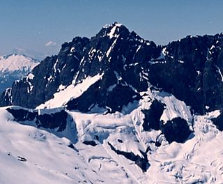
Seahpo Peak is a subsidiary peak of Mount Shuksan, which rises in the U.S. state of Washington. It is located about 2 miles (3.2 km) east of the main peak of Shuksan and rises to about 7,441 feet (2,268 m). It is located in North Cascades National Park and is part of the North Cascades range.

Logan Glacier is in Glacier National Park in the U.S. state of Montana. The glacier is situated in a cirque to the northeast of Mount Logan. Just east of the Continental Divide, Logan Glacier is northwest of Red Eagle Glacier. Estimated in 2005 to cover an area of 75 acres (0.30 km2), Logan Glacier covered almost 125 acres (0.51 km2) in 1966, a reduction in area of 40 percent in about 40 years. Comparing images of the glacier taken in 1914 with those from 2009, indicates that the glacier has experienced extensive retreat.

Crystal Glacier is in North Cascades National Park in the U.S. state of Washington, on the south slopes of Mount Shuksan. Descending 1.25 mi (2.01 km) from just east of the summit of Mount Shuksan, near its origination point, Crystal Glacier is connected to the larger Sulphide Glacier to the west. Crystal Glacier descends from 8,200 to 5,800 ft, and is also connected to East Nooksack Glacier as well as Hanging Glacier near it uppermost margins. Both Crystal and Sulphide Glaciers have a series of 300-to-1,000-foot high cascades which are collectively referred to as Sulphide Basin Falls. Below these cascades lies Sulphide Lake, which empties over Sulphide Creek Falls, one of the highest waterfalls in North America with a nearly 2,200 ft (670 m) drop.
Sulphide Glacier is in North Cascades National Park in the U.S. state of Washington, on the south slopes of Mount Shuksan. Descending 1.85 mi (2.98 km) from the summit tower of Mount Shuksan, it is connected to Crystal Glacier to the east. Sulphide Glacier descends from 8,600 to 5,600 ft. Sulphide Glacier is along the route taken when Mount Shuksan was first climbed in 1906. Both Sulphide and Crystal Glaciers have a series of 300-to-1,000-foot high cascades which are collectively referred to as Sulphide Basin Falls. Below these cascades lies Sulphide Lake, which empties over Sulphide Creek Falls, one of the highest waterfalls in North America with a nearly 2,200 ft (670 m) drop.

East Nooksack Glacier is in North Cascades National Park in the U.S. state of Washington, on the eastern slopes of Mount Shuksan. East Nooksack Glacier is only 0.70 mi (1.13 km), but fills the upper portions of the Nooksack Cirque, spanning more than 2 mi (3.2 km). East Nooksack Glacier is connected to Crystal Glacier at its uppermost section at 7,800 ft (2,400 m). East Nooksack Glacier extends from Nooksack Tower to the northwest to Seahpo Peak to the southeast and meltwater from the glacier flows into the Nooksack River.

Upper Curtis Glacier is in North Cascades National Park in the U.S. state of Washington, on the west slopes of Mount Shuksan. Upper Curtis Glacier is not connected to Lower Curtis Glacier downslope to the southwest, but is to Hanging Glacier to the north and to Sulphide Glacier to the east.

Hanging Glacier is in North Cascades National Park in the U.S. state of Washington, on the north slopes of Mount Shuksan. Hanging Glacier is connected to Crystal Glacier at its uppermost margin, and also flows into Upper Curtis Glacier. Hanging Glacier is along the route taken in the first technical ascent of Mount Shuksan in 1939.

Price Glacier is in North Cascades National Park in the U.S. state of Washington, on the northeast slopes of Mount Shuksan, below the subpeak known as Nooksack Tower. Price Glacier descends from 8,600 to 4,200 ft and is the steepest and most heavily crevasseed glacier on Mount Shuksan. The disconnected lowest portions of Price Glacier calve small icebergs into Price Lake.
White Salmon Glacier is in North Cascades National Park in the U.S. state of Washington, on the west slopes of Mount Shuksan. White Salmon Glacier is a series of small glaciers that descend to the north from a ridge feature known as Shuksan Arm. A climbers route follows the White Salmon Glacier to Fisher Chimney which provides a faster approach than others to the summit of Mount Shuksan.
West Nooksack Glacier is in North Cascades National Park in the U.S. state of Washington, on the eastern slopes of Mount Shuksan, immediately northeast of the subpeak called Nooksack Tower. West Nooksack Glacier is only .10 mi (0.16 km) in length and is a glacial remnant. West Nooksack Glacier provides meltwater for the Nooksack River.

Nooksack Tower is in North Cascades National Park in the U.S. state of Washington. Nooksack Tower is part of the Mount Shuksan Massif and is .75 mi (1.21 km) northeast of the main summit of Shuksan. Nooksack Tower looms to the west over Nooksack Cirque. The East Nooksack Glacier lies to the southeast, West Nooksack Glacier to the east and Price Glacier is on the north flanks of the tower. Nooksack Tower is one of the most difficult mountains to climb in the Cascade Range, with loose rock, 50-degree or greater slopes and ice ridges as well as accessibility issues and exposure, all weighing into the climbing equation. The descent may require ten or more rappels.
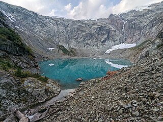
Sulphide Lake is located in North Cascades National Park, in the U. S. state of Washington. Sulphide Lake lies in a cirque on the southeast slopes of Mount Shuksan. Several major cascades drop as much as 1,000 ft (300 m) into Sulphide Lake including Sulphide Basin Falls which is from melt off the Sulphide Glacier. After Sulphide Creek drains from Sulphide lake, it then plunges at least 2,000 ft (610 m) over a series of cascades called Sulphide Creek Falls, which is one of the tallest waterfalls in the U.S.

Ruth Mountain is a 7,115 ft (2,170 m) Skagit Range summit located two miles south of Hannegan Pass in the North Cascades of Washington state. The name honors Ruth Cleveland, daughter of President Grover Cleveland. This mountain's name was officially adopted in 1952 by the United States Board on Geographic Names. Ruth Mountain is situated on the shared border of North Cascades National Park and the Mount Baker Wilderness, which is part of the Mount Baker-Snoqualmie National Forest. The summit offers views of Mount Shuksan, East Nooksack Glacier, Seahpo Peak, Nooksack Tower, Icy Peak, Mount Sefrit, Mineral Mountain, and the Picket Range. The melting and receding Ruth Glacier on the north slope of Ruth creates the headwaters for the Chilliwack River. Precipitation runoff also finds its way into the Nooksack and Baker Rivers.