
Sahale Mountain is a jagged, glaciated mountain, in North Cascades National Park, in northern Washington state. The summit of Sahale Mountain is referred to as Sahale Peak. It is 0.3 miles (0.48 km) south of its higher neighbor, Boston Peak, and the saddle between the two is 80 feet (24 m) lower than Sahale's summit. Quien Sabe Glacier is to the west of the ridge between the two peaks while Davenport Glacier is in a cirque east of this ridge and above Horseshoe Basin. Sahale Glacier is south of the summit and east of Sahale Arm, a ridge that extends southwest from Sahale to Cascade Pass. The name Sahale may originate from a Northwest Native American word meaning "high place," "falcon," or "sacred."
Seahpo Peak is a subsidiary peak of Mount Shuksan, which rises in the U.S. state of Washington. It is located about 2 miles (3.2 km) east of the main peak of Shuksan and rises to about 7,441 feet (2,268 m). It is located in North Cascades National Park and is part of the North Cascades range.
Forbidden Peak is an 8,815 feet (2,687 m) glacial horn located in North Cascades National Park, in Skagit County of Washington state. It is part of the North Cascades and is located near Cascade Pass. Forbidden Peak features a rock climbing route named West Ridge route which is featured in Fifty Classic Climbs of North America. The peak was first climbed by a party consisting of Fred Beckey, his brother Helmy Beckey, Jim Crooks, Lloyd Anderson and Dave Lind in 1940.

Mount Logan is located in North Cascades National Park in the U.S. state of Washington. Mount Logan is in a remote location of North Cascades National Park that requires hiking 20 mi (32 km) from a trailhead to reach the peak. The mountain itself is not a difficult climb, though the easiest approaches require traversing glaciers and ropes are recommended. The peak supports three glaciers including Banded Glacier to the north, Fremont Glacier to the southwest and Douglas Glacier on the southeast slopes.

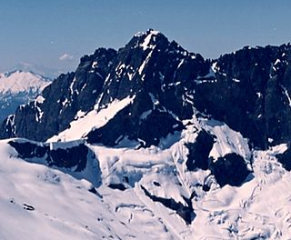
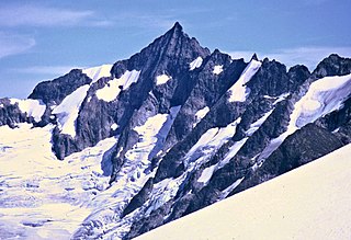
Nooksack Tower is in North Cascades National Park in the U.S. state of Washington. Nooksack Tower is part of the Mount Shuksan Massif and is .75 mi (1.21 km) northeast of the main summit of Shuksan. Nooksack Tower looms to the west over Nooksack Cirque. The East Nooksack Glacier lies to the southeast, West Nooksack Glacier to the east and Price Glacier is on the north flanks of the tower. Nooksack Tower is one of the most difficult mountains to climb in the Cascade Range, with loose rock, 50-degree or greater slopes and ice ridges as well as accessibility issues and exposure, all weighing into the climbing equation. The descent may require ten or more rappels.

Mount Larrabee is a 7,865-foot (2,397-metre) Skagit Range mountain summit situated 1.4 mile south of the Canada–United States border, in the North Cascades of Washington state. It is located immediately southeast of American Border Peak within the Mount Baker Wilderness, which is part of the Mount Baker-Snoqualmie National Forest, and near North Cascades National Park. It is notable for its reddish coloring caused by oxidation of Iron in the rock. The rock consists of reddish interbedded and interfolded phyllites and greenstone. Originally known as Red Mountain, the name was changed in 1951 to honor Charles F. Larrabee (1895–1950), of the prominent Larrabee family of Bellingham, Washington. The toponym was officially adopted in 1951 by the U.S. Board on Geographic Names.

Frisco Mountain is a 7,760-foot (2,365-metre) mountain summit in the Cascade Range in the U.S. state of Washington. It is located two miles southwest of Rainy Pass on the borders of the Stephen Mather Wilderness and North Cascades National Park. First climbed by surveyor Lage Wernstedt in 1926, the mountain derives its name from a mining claim on the south side that was worked in the 1920s. Its nearest higher peak is Rainy Peak, 0.54 mi (0.87 km) to the east-southeast. Precipitation runoff from Frisco Mountain drains into Rainy Lake and tributaries of Bridge Creek. The retreating Lyall Glacier in its northeast cirque contributes to waterfalls which tumble 1,000 ft (300 m) into Rainy Lake.

Ruth Mountain is a 7,115 ft (2,170 m) Skagit Range summit located two miles south of Hannegan Pass in the North Cascades of Washington state. The name honors Ruth Cleveland, daughter of President Grover Cleveland. This mountain's name was officially adopted in 1952 by the United States Board on Geographic Names. Ruth Mountain is situated on the shared border of North Cascades National Park and the Mount Baker Wilderness, which is part of the Mount Baker-Snoqualmie National Forest. The summit offers views of Mount Shuksan, East Nooksack Glacier, Seahpo Peak, Nooksack Tower, Icy Peak, Mount Sefrit, Mineral Mountain, and the Picket Range. The melting and receding Ruth Glacier on the north slope of Ruth creates the headwaters for the Chilliwack River. Precipitation runoff also finds its way into the Nooksack and Baker Rivers.

Magic Mountain is a 7,610-foot (2,320-metre) mountain summit located on the shared boundary of Skagit County and Chelan County in Washington state. It is part of the North Cascades, a subset of the Cascade Range. Magic Mountain is situated southeast of Cascade Pass on the shared border of North Cascades National Park and Glacier Peak Wilderness. The nearest peak is Pelton Peak 0.4 miles (0.64 km) to the northeast, and the nearest higher peak is Hurry-up Peak 0.83 miles (1.34 km) to the south. The Yawning Glacier and Cache Col Glacier rest on its northern flank. Magic Mountain is at the northern end of the Ptarmigan Traverse. Surface runoff on the north side the mountain drains into the Stehekin River, while precipitation drains into the Cascade River from the southwest side.

Mix-up Peak, also known as Mixup Peak, is a 7,440-foot (2,270-metre) mountain summit located on the shared boundary of Skagit County and Chelan County in Washington state. It is part of the North Cascades Range and is situated one mile south of Cascade Pass on the shared border of North Cascades National Park and Glacier Peak Wilderness. The nearest higher peak is Magic Mountain, 1.02 miles (1.64 km) to the east-southeast. Mix-up Peak is at the northern end of the Ptarmigan Traverse which is an alpine route to remote mountains such as Mount Formidable and Dome Peak. The Cache Glacier occupies a cirque below its eastern flank. Surface runoff on the east side the mountain drains into the Stehekin River, whereas precipitation runoff drains into the Cascade River from the west side.

Mount Sefrit is a 7,191 ft (2,190 m) Skagit Range summit located three miles north of Mount Shuksan in the North Cascades of Washington state. It is situated in the Mount Baker Wilderness, which is managed by the Mount Baker-Snoqualmie National Forest. The summit offers views of Mount Shuksan, Mount Baker, and the Picket Range. Mount Sefrit's name honors Frank Ira Sefrit (1867–1950), editor and publisher of The Bellingham Herald for nearly 40 years. This mountain's name was officially adopted in 1952 by the U.S. Board on Geographic Names. Precipitation runoff from the mountain drains into the deep valleys of Ruth Creek and the Nooksack River which nearly encircle Mount Sefrit, except for Nooksack Ridge which connects it to Ruth Mountain.

Goat Mountain is a 6,844-foot (2,086-metre) summit in the Skagit Range which is a subset of the North Cascades of Washington state. It is located south of Mount Larrabee and north of Mount Shuksan in the Mount Baker Wilderness, which is managed by the Mount Baker-Snoqualmie National Forest. Goat Mountain has a subsidiary 6,725 ft summit known as the west peak, and remnants of what was colloquially known as the Swamp Creek Glacier rest on the northern slope between the two summits. The nearest higher neighbor is Mount Chardonnay, 2.75 mi (4.43 km) to the east. The Silver Tip Mine was located on the south slope of the mountain near the 3,000 ft level. The mine produced silver and gold in the 1940s. Precipitation runoff from the mountain drains into tributaries of the Fraser River and the Nooksack River.

Inspiration Peak is a 7,891-foot (2,405-metre) mountain summit located in the Picket Range within North Cascades National Park in the state of Washington. The peak lies 0.28 mi (0.45 km) east of Mount Degenhardt, and 0.47 mi (0.76 km) west of McMillan Spires. Terror Glacier remnants lie to the south of the peaks, and the McMillan Cirque glaciers hang on the north slopes. The first ascent of Inspiration Peak was made in 1940 by Fred Beckey and his brother Helmy via the West Ridge. Inspiration Peak can be seen from the North Cascades National Park Newhalem visitor center, weather permitting.
Kololo Peaks is an 8,200+ ft mountain located in the Glacier Peak Wilderness of the North Cascades in Washington state. The mountain is situated on the crest of the Cascade Range, on the shared border of Snohomish County and Chelan County, and also straddling the boundary between Mount Baker-Snoqualmie National Forest and Wenatchee National Forest. The nearest higher peak is Glacier Peak, 3.29 mi (5.29 km) to the north. Precipitation runoff and meltwater from the White River Glacier on the southeast slope drains into White River. On the west slope, the White Chuck Glacier drains into the White Chuck River, and the Suiattle Glacier and Honeycomb Glacier on the north and east sides drain into the Suiattle River. Surrounded by these glaciers, Fred Beckey in his Cascade Alpine Guide describes the mountain as being almost a nunatak.

Napeequa Peak is an 8,073-foot (2,461-metre) pyramidal mountain summit located in the Glacier Peak Wilderness of the North Cascades in Washington state. The mountain is situated on the crest of the Cascade Range, on the shared border of Snohomish County and Chelan County, also straddling the boundary between the Mount Baker-Snoqualmie National Forest and the Wenatchee National Forest. Its nearest neighbor is Cirque Mountain, 0.3 mi (0.48 km) to the north, and the nearest higher peak is Buck Mountain, 2.56 mi (4.12 km) to the east-southeast. Precipitation runoff from the peak drains east to the headwaters of Napeequa River; or west into the Suiattle River. The mountain's name is taken from the river's name, which was applied by Albert Hale Sylvester (1871-1944), a pioneer surveyor, explorer, topographer, and forest supervisor in the Cascades.

Brahma Peak is a remote 8,079-foot (2,462-metre) mountain summit located on Chiwawa Ridge in the North Cascades, in Chelan County of Washington state. The mountain is situated in the Glacier Peak Wilderness, on land managed by the Wenatchee National Forest. The nearest higher neighbor is Buck Mountain, 1.8 mi (2.9 km) to the north. Brahma and Buck are set on Chiwawa Ridge, and other notable peaks on this ridge include Fortress Mountain, Cirque Mountain, Napeequa Peak, Mount Berge, Bandit Peak, and Chiwawa Mountain. Precipitation runoff from Brahma and meltwater from its glacier remnants drains into Chiwawa River and Napeequa River, both tributaries of the Wenatchee River. Topographic relief is significant since the southwest lavender-colored schist cliffs of this peak rise nearly 4,000 feet above the Napeequa River Valley in approximately one mile.

Cirque Mountain is a 7,966-foot (2,428-metre) mountain summit located in the Glacier Peak Wilderness of the North Cascades in Washington state. The mountain is situated on the crest of the Cascade Range, on the shared border of Snohomish County and Chelan County, also straddling the boundary between the Mount Baker-Snoqualmie National Forest and the Wenatchee National Forest. Its nearest higher peak is Napeequa Peak, 0.3 mi (0.48 km) to the south. The peak is set on Chiwawa Ridge with Napeequa, and other notable peaks on this ridge include Fortress Mountain, Buck Mountain, Brahma Peak, Mount Berge, and Chiwawa Mountain. Topographic relief is significant since the western aspect of the mountain rises 4,000 feet above the Suiattle Valley in approximately 1.5 mi (2.4 km). This mountain has small, unnamed, hanging glaciers in cirques surrounding the summit. Precipitation runoff from the peak and meltwater from the glaciers drains east to the headwaters of Napeequa River; or west into the Suiattle River.

Tenpeak Mountain is an 8,312-foot (2,533-metre) mountain summit located in the Glacier Peak Wilderness of the North Cascades in Washington state. Tenpeak is situated on the crest of the Cascade Range, on the shared border of Snohomish County and Chelan County, also straddling the boundary between the Mount Baker-Snoqualmie National Forest and the Wenatchee National Forest. Its nearest higher neighbor is Luahna Peak, 2.5 mi (4.0 km) to the southeast. Topographic relief is significant since the northern aspect of the mountain rises 4,200 feet above the Suiattle Valley in approximately 1.5 mi (2.4 km). This mountain has small, unnamed, hanging glaciers in cirques surrounding the summit, and the terminus of the Honeycomb Glacier lies below the western base of the mountain. Precipitation runoff from the mountain and meltwater from the glaciers drains south into White River; or north into the Suiattle River. This mountain's descriptive name was suggested by The Mountaineers, and was officially adopted in 1918 by the U.S. Board on Geographic Names. The first ascent was made September 21, 1940, by Lloyd Anderson and Tom Campbell.

Mount Berge is a 7,951-foot (2,423-metre) double-summit granitic mountain located in the Glacier Peak Wilderness of the North Cascades, in Chelan County of Washington state. The mountain is situated along the crest of the Cascade Range, on land managed by the Okanogan–Wenatchee National Forest. Its nearest higher neighbor is Napeequa Peak, 1.2 mi (1.9 km) to the west, and Buck Mountain is 1.7 mi (2.7 km) to the east-southeast. Berge is positioned on Chiwawa Ridge with Buck and Napeequa, and other notable peaks on this ridge include Fortress Mountain, Brahma Peak, Cirque Mountain, Helmet Butte, and Chiwawa Mountain. Precipitation runoff from Berge drains to the headwaters of Napeequa River; or east into tributaries of the Chiwawa River.

Bandit Peak is a 7,625-foot (2,324-metre) double-summit granitic mountain located in the Glacier Peak Wilderness of the North Cascades, in Chelan County of Washington state. The mountain is situated east of the crest of the Cascade Range, on land managed by the Okanogan–Wenatchee National Forest. Its nearest higher neighbor is Brahma Peak, 5.9 mi (9.5 km) to the north. Bandit Peak is the ninth-highest peak on Chiwawa Ridge, and other notable peaks on this ridge include Mount Berge, Buck Mountain, Cirque Mountain, Napeequa Peak, Helmet Butte, and Chiwawa Mountain. Precipitation runoff from Bandit Peak drains west into Napeequa River; or east into the Chiwawa River.


