Icy Peak (Alaska)

Last updated
Icy Peak
Icy Peak, Alaska.jpg
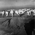
Northwest aspect, in 1960
Highest point
Elevation 4,550 ft (1,390 m) [1]
Prominence 1,300 ft (396 m) [1]
Parent peak Mount Kialagvik [1]
Isolation 8.52 mi (13.71 km) [1]
Coordinates 57°15′01″N156°32′09″W / 57.2502573°N 156.5357253°W / 57.2502573; -156.5357253 [2]
Geography
Relief map of USA Alaska.png
Red triangle with thick white border.svg
Icy Peak
Location in Alaska
CountryUnited States
State Alaska
Borough Kodiak Island Borough [2]
Protected area Alaska Peninsula National Wildlife Refuge
Parent range Aleutian Range [2]
Topo map USGS Ugashik B-2

Icy Peak is a 4,550-foot-elevation (1,390-meter) mountain summit in Alaska, United States.

Contents

Description

Part of the Aleutian Range, Icy Peak is set 9.5 miles (15.3 km) southwest of Cape Kayakliut on the south coast of the Alaska Peninsula and within the Alaska Peninsula National Wildlife Refuge. [2] Precipitation runoff and glacial meltwater from the mountain drains north into Kialagvik Creek, and south into Glacier Creek and Agripina River. Topographic relief is significant as the summit rises over 4,500 feet (1,372 meters) above tidewater of Wide Bay in approximately two miles (3.2 km). The mountain's local descriptive name was published by the United States Coast and Geodetic Survey in the early 1880s and the toponym has been officially adopted by the United States Board on Geographic Names. [2] [3]

Climate

According to the Köppen climate classification system, Icy Peak is located in a subpolar oceanic climate zone with cold, snowy winters, and cool summers. [4] Weather systems coming off the North Pacific are forced upwards by the mountains (orographic lift), causing heavy precipitation in the form of rainfall and snowfall. Winter temperatures can drop to 0 °F with wind chill factors below −10 °F. This climate supports 2.5 square miles (6.5 km2) of unnamed glaciers and ice on the slopes surrounding the peak. [5]

See also

Related Research Articles

<span class="mw-page-title-main">Mount Merriam</span> Mountain in Alaska

Mount Merriam is a prominent 5,083-foot (1,549-meter) mountain summit located in Glacier Bay National Park and Preserve, in the Alsek Ranges of the Saint Elias Mountains, in southeast Alaska. The mountain is situated 75 mi (121 km) northwest of Juneau, 3.1 mi (5 km) south of Mount Wordie, 3.5 mi (6 km) north of Black Cap Mountain, and 13.4 mi (22 km) southeast of Mount Abdallah which is the nearest higher peak. Although modest in elevation, relief is significant as the mountain rises up from tidewater in less than three miles, and it ranks 85th in prominence for all peaks in Alaska. The mountain was named by members of a 1941 Glacier Bay expedition for Dr. Clinton Hart Merriam (1855-1942), Chief of the U.S. Department of Agriculture (USDA) Biological Survey. Merriam was a zoologist for the 1899 Harriman Alaska expedition which explored Glacier Bay. Weather permitting, Mount Merriam can be seen from Glacier Bay, which is a popular destination for cruise ships. The months May through June offer the most favorable weather for viewing or climbing the peak.

<span class="mw-page-title-main">Castle Mountain (Alaska)</span> Mountain summit in the state of Alaska

Castle Mountain is a remote 8,620-foot (2,630-meter) mountain summit located at the southeastern edge of the Wrangell Mountains, in the U.S. state of Alaska. The peak is situated 35 mi (56 km) northeast of McCarthy at Skolai Pass in Wrangell-St. Elias National Park and Preserve. Although modest in elevation, relief is significant as the south face rises 4,000 feet above the terminus of the Russell Glacier in less than one mile. Precipitation runoff from the peak drains east via the White River, and west to the Nizina River via Skolai Creek. The mountain's descriptive name was reported in 1914 by the United States Geological Survey.

<span class="mw-page-title-main">Mount Carmack</span> Mountain in Alaska, United States

Mount Carmack is a prominent 6,808-foot-elevation (2,075-meter) mountain summit located in the Boundary Ranges of the Coast Mountains, in the U.S. state of Alaska. The peak is situated 7 mi (11 km) north-northeast of Skagway, and 3.5 mi (6 km) south of Mount Cleveland, on land managed by Tongass National Forest. As the highpoint on the divide between the Taiya River and the Skagway River, precipitation runoff from the mountain drains east into the Skagway River and west into Taiya River, both of which empty into Taiya Inlet. Although modest in elevation, relief is significant since Mount Carmack rises 6,800 feet above the Taiya valley in less than 2 mi (3 km), and 5,800 feet above Skagway valley in about 2 miles. Mount Carmack has a lower subsidiary summit, elevation 6,621 ft (2,020 m), about 0.5 mi (1 km) to the northeast of the true summit. The USGS topographic map has this lower northeast peak labelled as Mount Carmack.

<span class="mw-page-title-main">Awesome Peak</span>

Awesome Peak is an 8,645-foot-elevation (2,635-meter) mountain summit located 35 miles (56 km) east-northeast of Palmer, in the northern Chugach Mountains of Alaska. This peak of the Matanuska Valley is set midway between Anchorage and Glennallen, near mile 90 of the Glenn Highway. It is situated 15 miles (24 km) west of Matanuska Glacier and 3.7 mi (6 km) southwest of Amulet Peak. Precipitation runoff from the mountain drains into Monument and Coal creeks, which are tributaries of the Matanuska River. Topographic relief is significant as the summit rises 5,650 feet above Coal Creek in 3.75 miles (6 km) and 4,650 feet above Monument Creek in 1.9 mile (3 km). This mountain's toponym has not been officially adopted by the United States Board on Geographic Names, so it is only marked as "8645" on USGS maps.

<span class="mw-page-title-main">Mount Leeper</span>

Mount Leeper is a 9,603-foot-elevation (2,927-meter) mountain summit in Alaska, United States.

<span class="mw-page-title-main">Lowell Peak (Chugach Mountains)</span> Mountain in Alaska

Lowell Peak is a 4,728-foot (1,441 m) mountain summit in the U.S. state of Alaska.

<span class="mw-page-title-main">Mount Stepo</span>

Mount Stepo is a 3,828-foot-elevation (1,167-meter) mountain summit in Alaska.

<span class="mw-page-title-main">Barometer Mountain</span>

Barometer Mountain is a 2,506-foot-elevation (764-meter) summit in Alaska.

<span class="mw-page-title-main">Mount Silvertip</span>

Mount Silvertip is a 9,400-foot-elevation (2,865-meter) mountain summit in Alaska.

<span class="mw-page-title-main">Raggedtop Mountain</span>

Raggedtop Mountain is a 5,215-foot-elevation (1,590-meter) mountain summit in Alaska, United States.

<span class="mw-page-title-main">Jewel Mountain</span>

Jewel Mountain is a 4,885-foot-elevation (1,489-meter) mountain summit in Alaska, United States.

<span class="mw-page-title-main">Santa Ana Peak</span>

Santa Ana Peak is a 4,764-foot-elevation (1,452-meter) mountain summit in Alaska, United States.

<span class="mw-page-title-main">Mount Sumdum</span>

Mount Sumdum is a 6,666-foot-elevation (2,032-meter) mountain summit in Alaska, United States.

<span class="mw-page-title-main">Tiehacker Mountain</span>

Tiehacker Mountain is a 4,435-foot-elevation (1,352-meter) mountain summit in Alaska, United States.

<span class="mw-page-title-main">The Tusk (Alaska)</span>

The Tusk is a 6,650-foot-elevation (2,027-meter) mountain summit in Alaska, United States.

<span class="mw-page-title-main">Paradise Peak (Kenai Mountains)</span>

Paradise Peak is a 6,050-foot-elevation (1,844-meter) mountain summit in Alaska, United States.

<span class="mw-page-title-main">Mount Ada</span>

Mount Ada is a 4,528-foot-elevation (1,380-meter) mountain summit in Alaska, United States.

<span class="mw-page-title-main">Alabaster Peak</span>

Alabaster Peak is an 8,065-foot-elevation (2,458-meter) mountain summit located 35 miles (56 km) east of Palmer, in the northern Chugach Mountains of Alaska. This peak of the Matanuska Valley is set midway between Anchorage and Glennallen, and can be seen from the Glenn Highway. It is situated 15 miles (24 km) west of Matanuska Glacier and 1.8 miles (2.9 km) south of Awesome Peak. Precipitation runoff from the mountain drains into Coal, Monument, and Gravel creeks, which are tributaries of the Matanuska River. Topographic relief is significant as the summit rises 3,065 feet along the west slope in one mile (1.6 km). The first ascent of the summit was made on July 4, 1970, by Robert Spurr, Bob Pelz, and Royce Purinton via the Spectrum Glacier and North Ridge. This mountain's toponym has not been officially adopted by the United States Board on Geographic Names, so it is only marked as "8065" on USGS maps.

<span class="mw-page-title-main">Mustang Peak (Coast Mountains, Alaska)</span>

Mustang Peak is a 6,720-foot-elevation (2,048-meter) glaciated mountain summit located in the Boundary Ranges of the Coast Mountains, in the U.S. state of Alaska. It is situated 25 miles (40 km) north-northwest of Juneau along the western side of the Juneau Icefield, on land managed by Tongass National Forest. Topographic relief is significant as the summit rises 1,200 feet (366 m) above the Eagle Glacier in 0.25 mi (0.40 km). Neighbors include Dike Mountain 0.8 mi (1.3 km) to the north, and The Snow Towers are three miles (4.8 km) to the southeast. Mustang Peak was named by members of the Juneau Icefield Research Project in 1964, and the toponym was officially adopted in 1965 by the U.S. Board on Geographic Names.

<span class="mw-page-title-main">Glacier King</span>

Glacier King is a 6,500-foot-elevation (1,981-meter) mountain summit in Alaska, United States.

References

  1. 1 2 3 4 "Icy Peak - 4,550' AK". listsofjohn.com. Retrieved 2023-12-13.
  2. 1 2 3 4 5 "Icy Peak". Geographic Names Information System . United States Geological Survey, United States Department of the Interior . Retrieved 2023-12-13.
  3. Donald J. Orth, Dictionary of Alaska Place Names, U.S. Government Printing Office, 1967, page 442.
  4. Peel, M. C.; Finlayson, B. L.; McMahon, T. A. (2007). "Updated world map of the Köppen−Geiger climate classification". Hydrol. Earth Syst. Sci. 11. ISSN   1027-5606.
  5. American Geographical Society of New York, Mountain Glaciers of the Northern Hemisphere: Alaska and adjacent Canada. Arctic Canada. North Atlantic Islands, 1975, p.627.