Interstate 295 (I-295), sometimes called the Providence Beltway, is an auxiliary Interstate Highway in the US states of Rhode Island and Massachusetts. It is maintained by the Rhode Island Department of Transportation (RIDOT) and the Massachusetts Department of Transportation (MassDOT). Spanning nearly 27 miles (43 km), it forms a western beltway around Providence, Rhode Island, and is a bypass of I-95 as it travels through the capital city. I-895 was proposed as a complementary eastern beltway to complete a full loop around the city in the 1960s but was ultimately scrapped in the 1980s.

Interstate 195 (I-195) is an auxiliary Interstate Highway running a combined 44.55 miles (71.70 km) in the US states of Rhode Island and Massachusetts. It travels from a junction with I-95 in Providence, Rhode Island, east to a junction with I-495 and Massachusetts Route 25 in Wareham, Massachusetts. It runs east–west and passes through the cities of Fall River, Massachusetts, and New Bedford, Massachusetts. The portion of I-195 in East Providence is also known as the East Providence Expressway.
The U.S. state of Rhode Island has 70 state highways, coordinated and signed by the Rhode Island Department of Transportation (RIDOT). Most of these are partly or fully state highways, roads owned and maintained by RIDOT. Every city and town in Rhode Island, except for New Shoreham, has at least one numbered route.

Route 3 is a 30.1-mile-long (48.4 km) state highway in the U.S. state of Rhode Island. Route 3 serves as a local alternative to Interstate 95 (I-95) as it parallels I-95 for almost its entire length. Route 3 in West Warwick was the site of The Station nightclub fire.

Route 10 is a numbered state highway connector in the U.S. state of Rhode Island, traveling along the Huntington Expressway, the first freeway in the state. It connects Route 12 on the Cranston–Providence city line with Interstate 95 (I-95), U.S. Route 6 (US 6), and Memorial Boulevard in downtown Providence, passing just east of the Olneyville area of Providence. It provides an alternate route to I-95 south of downtown, and connects it with the US 6 freeway west from Olneyville towards I-295 and Connecticut.

Route 37 is a state highway running 3.47 miles (5.58 km) in Providence County and Kent County, Rhode Island, United States. A freeway for its entire length, it serves the cities of Cranston and Warwick and is also a major east–west freeway in the Providence metropolitan area, linking T. F. Green Airport with Interstate 295. The western terminus of Route 37 is an at-grade intersection with Natick Avenue in Cranston. The freeway has numbered interchanges with I-295, Rhode Island Route 2, Pontiac Avenue, and I-95 before terminating at a trumpet interchange with U.S. Route 1 in Warwick.
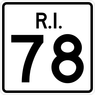
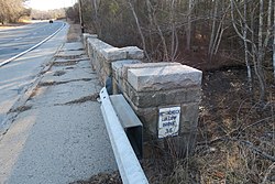
Route 78, also known as the Westerly Bypass, is a two-lane divided freeway between Pawcatuck, Connecticut, to Westerly, Rhode Island. The route is about 4.6 miles (7.4 km) long and begins at Connecticut Route 2 in Stonington, crossing into Rhode Island at the Pawcatuck River, where it continues to U.S. Route 1 in Westerly. The route was constructed in 1979, after a sixteen-year delay. The designation was to become part of the Orient Point–Watch Hill Bridge, but this plan was later dropped. The route was given the memorial name of Veterans Way in 2004.

Route 102 is a 44.4-mile-long (71.5 km) numbered state highway in the U.S. state of Rhode Island. Route 102 serves as a non-freeway beltway around the Providence metro area. It begins in the village of Wickford and travels through less developed areas of western Rhode Island. The route ends in the village of Slatersville.
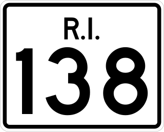
Route 138 is a numbered State Highway running 48.3 miles (77.7 km) in Rhode Island. It is the longest state numbered route in Rhode Island, and the second longest highway after US 1. Route 138 begins in Exeter at the Connecticut state line in the west and runs to the Massachusetts state line in Tiverton in the east, and is the only state-numbered route to completely cross Rhode Island. Route 138 also keeps the same route number on the other side of both state lines.
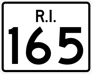
Route 165 is a 7.1-mile-long (11.4 km) numbered state highway in the U.S. state of Rhode Island. Its western terminus is a continuation of Connecticut Route 165 at the Connecticut border, and its eastern terminus is at Rhode Island Route 3 in Exeter. It runs entirely on Ten Rod Road, where one rod is 16.5 feet and so ten rods is 165 feet, matching the route number.

The Moshassuck River is a river in the U.S. state of Rhode Island. It flows 8.9 miles (14.3 km) from the town of Lincoln to the city of Providence. There are six dams along the river's length.

Interstate 95 (I-95) is the main north–south Interstate Highway on the East Coast of the United States, running generally southwest–northeast through the US state of Rhode Island. It runs from the border with Connecticut near Westerly, through Warwick and Providence, and to the Massachusetts state line in Pawtucket. It has two auxiliary routes, both of which enter Massachusetts—I-195, a spur from Providence east to Cape Cod, and I-295, a western bypass of the Providence metropolitan area.

The Nooseneck River is a river in the U.S. state of Rhode Island. It flows approximately 5.5 miles (8.9 km). There are three dams along the river's length.
The Big River is a river in the U.S. state of Rhode Island. It flows 6.8 miles (10.9 km). There are no dams along the river's length.
The Ashaway River is a river in the U.S. states of Rhode Island and Connecticut. It flows approximately 4 km (2 mi). There are three dams along the river's length.

Wyoming is a village and census-designated place on the Wood River in southern Rhode Island, primarily in the town of Richmond, Rhode Island, but extending north across the river into the town of Hopkinton, Rhode Island. The population was 270 at the 2010 census. It is the site of the Wyoming Village Historic District and a post office assigned ZIP code 02898.

Interstate 895 was a proposed Interstate Highway in Rhode Island and Massachusetts that would have supplemented Interstate 295 to create a full beltway around Providence.
Canonchet is a small village in the town of Hopkinton in the U.S. state of Rhode Island.
Transportation in New England encompasses the region's rail and highway networks, seaports, and airports. New England has one of the United States' oldest intercity transportation systems, which remain important to the region's economy. It is also home to the continent's first subway system. The densely populated area has many cities and towns connected by rail and road, and the larger cities each have commercial airports with daily flights to destinations outside of the region.