| Nordfjord | |
|---|---|
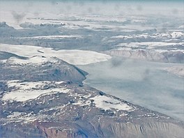 View of the Nordfjord with the calving end of the Waltershausen Glacier | |
 Nordfjord Location within Greenland | |
| Location | NE Greenland |
| Coordinates | 73°40′N24°15′W / 73.667°N 24.250°W |
| Ocean/sea sources | Kaiser Franz Joseph Fjord Greenland Sea |
| Basin countries | Greenland |
| Max. length | 60 kilometres (37 mi) |
| Max. width | 13.3 kilometres (8.3 mi) |
| Average depth | 49 metres (161 ft) |
Nordfjord is a fjord in the NE Greenland National Park area, East Greenland.
Contents
The fjord was named in 1899 by Swedish Arctic explorer A.G. Nathorst during the expedition he led to Greenland. In 1931 a scientific station known as Nordfjordhuset was built on the western shore of the fjord at the time of the 1931–34 Treårsekspeditionen . [1]
